We Recommend:
Bach Steel - Experts at historic truss bridge restoration.
BridgeHunter.com Phase 1 is released to the public! - Visit Now
Brink Road Bridge

Primary Photographer(s): Nathan Holth
Bridge Documented: November 4, 2005 and February 20, 2022
Rural: Branch County, Michigan: United States
2000
38.7 Feet (11.8 Meters)
41.0 Feet (12.5 Meters)
16 Feet (4.88 Meters)
1 Main Span(s)
12304H00033B010

View Information About HSR Ratings
Bridge Documentation
This bridge's future is at risk!
Bridge Status: This bridge has been closed to traffic, and as of 2022 is slated for demolition without replacement at an unknown date.View Archived National Bridge Inventory Report - Has Additional Details and Evaluation
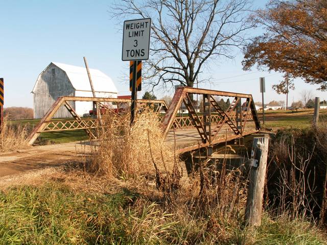
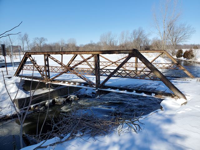
Composed of three panels, this half-hip Pratt pony truss is open to traffic with a three ton weight limit. Apparently, a nearby resident convinced the road commission to not demolish the bridge. They may have had more control over the matter than the average person because the road does not really serve any purpose other than to provide access to the few homes on it. The bridge now has a fairly new wood deck. The truss could benefit from a repainting project, but is in otherwise good condition. The bridge sits on concrete abutments, although random rubble stone abutments can be seen behind them.
Constructed in 1905, this bridge is technologically significant as an early surviving example of a rigid-connected truss bridge in Michigan. The rigid connections on the Brink Road Bridge are primarily riveted connections, but some bolts are present. Earlier truss bridges built in Michigan, and even some built after this bridge employed pin-connections, which for decades had been the standard for connecting the parts of a truss bridge together in the United States. Pin-connected truss bridges were easy to assemble on-site and did not require field riveting. Field riveting was not economical at the time. However by the turn of the 20th Century, a transition toward more rigid riveted connections took place, which engineers felt provided a more durable and dependable bridge. Hand-held pneumatic rivet hammers started to come on the scene. These rivet hammers would make it economical to do the field riveting needed to build a rivet-connected truss bridge. In the meantime, some bridge builders managed to avoid both field riveting and pin connections by attaching the parts of the bridge that were shipped to the construction site together using bolts. Such was the case with the Brink Road Bridge. The presence of rivets on the bridge indicates parts of the bridge that were pre-fabricated in the bridge shop. The presence of bolts indicate where the parts of the bridge that were put together in the field. As a result, some connections on the Brink Road Bridge are half riveted and half bolted.
The Brink Road Bridge's most significant feature however is not its early use of rigid connections. Instead it is the fact that despite the rigid truss connections, the Brink Road Bridge does not completely abandon the use of pins. Pins can be found on the two center bottom chord connections of each truss. This pin holds a u-bolt hanger, which holds the bridge's floor beams in place. The use of u-bolt hangers to attach floor beams to the truss system of a bridge was the traditional method used during the pin-connected era. The same bottom chord pin that held the truss parts together also held the u-bolt hanger for the floor beam. When engineers switched to riveted connections on truss bridges, the floorbeams were normally riveted directly to the gusset plate of a truss, again following the concept of keeping everything on the truss as rigid as possible. However, the Brink Road Bridge does not have the floor beams riveted to a gusset plate, but instead continues the traditional method of hanging the floorbeams from a pin using a u-bolt. As such, the Brink Road Bridge, with is combination of rigid truss connections and pin and hanger attachments for the floor beams appears to be technologically significant as a "transition" bridge that documents a progression from pin technology to rigid technology.
The truss bridge is configured as follows. Diagonal members: paired angles with battens. Railing: Two angles connected by a single row of lattice composed of bars and riveted at all intersection points (hub-guard style). End post and top chord: back-to-back channels with cover plate and battens. Vertical members: back-to-back channels with battens on each side. Bottom chord: paired angles with battens. Floor beams: rolled American Standard Beam type i-beams. Deck stringers: Rolled American Standard Beam type i-beams. Current deck type: Timber. Observed steel fabricator marks: Cambria.
The bridge's truss superstructure appears to retain excellent historic integrity with no alterations.
![]()
Photo Galleries and Videos: Brink Road Bridge
Bridge Photo-Documentation
Original / Full Size PhotosA collection of overview and detail photos. This gallery offers photos in the highest available resolution and file size in a touch-friendly popup viewer.
Alternatively, Browse Without Using Viewer
![]()
Bridge Photo-Documentation
Mobile Optimized PhotosA collection of overview and detail photos. This gallery features data-friendly, fast-loading photos in a touch-friendly popup viewer.
Alternatively, Browse Without Using Viewer
![]()
Additional Unorganized Photos
Original / Full Size PhotosA supplemental collection of photos that are from additional visit(s) to the bridge and have not been organized or captioned. This gallery offers photos in the highest available resolution and file size in a touch-friendly popup viewer.
Alternatively, Browse Without Using Viewer
![]()
Additional Unorganized Photos
Mobile Optimized PhotosA supplemental collection of photos that are from additional visit(s) to the bridge and have not been organized or captioned. This gallery features data-friendly, fast-loading photos in a touch-friendly popup viewer.
Alternatively, Browse Without Using Viewer
![]()
Maps and Links: Brink Road Bridge
Coordinates (Latitude, Longitude):
Search For Additional Bridge Listings:
Bridgehunter.com: View listed bridges within 0.5 miles (0.8 kilometers) of this bridge.
Bridgehunter.com: View listed bridges within 10 miles (16 kilometers) of this bridge.
Additional Maps:
Google Streetview (If Available)
GeoHack (Additional Links and Coordinates)
Apple Maps (Via DuckDuckGo Search)
Apple Maps (Apple devices only)
Android: Open Location In Your Map or GPS App
Flickr Gallery (Find Nearby Photos)
Wikimedia Commons (Find Nearby Photos)
Directions Via Sygic For Android
Directions Via Sygic For iOS and Android Dolphin Browser
USGS National Map (United States Only)
Historical USGS Topo Maps (United States Only)
Historic Aerials (United States Only)
CalTopo Maps (United States Only)


