We Recommend:
Bach Steel - Experts at historic truss bridge restoration.
BridgeHunter.com Phase 1 is released to the public! - Visit Now
Goodwin Road Bridge
Primary Photographer(s): Nathan Holth
Bridge Documented: 2005, March 1, 2007 - March 20, 2022
Rural: Ionia County, Michigan: United States
1909 By Builder/Contractor: Riverside Bridge Company of Martins Ferry, Ohio
Not Available or Not Applicable
148.0 Feet (45.1 Meters)
300.0 Feet (91.4 Meters)
13.5 Feet (4.11 Meters)
2 Main Span(s)
34314H00015B010

View Information About HSR Ratings
Bridge Documentation
This bridge's future is at risk!
2022 Update: Note that this bridge has been completely fenced off and closed to all traffic, including pedestrians.
View Archived National Bridge Inventory Report - Has Additional Details and Evaluation
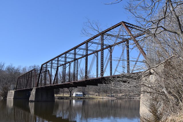
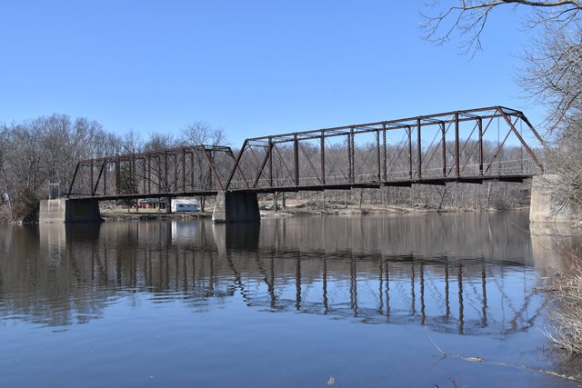
This bridge is a beautiful example of a two span Pratt through truss. The Goodwin Road Bridge is distinguished as one of only five surviving multi-span pin-connected highway through truss bridges. The vast majority of Michigan's surviving metal truss bridges of any kind are single span, and multi-span truss bridges of any kind are rare in Michigan due to the lack of many even modestly sized rivers in the state.

The bridge was fabricated in 1909 by the Riverside Bridge Company of Martin's Ferry, Ohio using steel purchased from Lackawanna and Carnegie mills. Wynkoop and McGormley of Toledo, Ohio is listed as the contractor for the bridge in a 1969 county bridge record. It is the only known example of the obscure Riverside Bridge Company's work in Michigan. As of 2011, no other examples of this builder's work surviving in any state had been identified by either HistoricBridges.org or www.bridgehunter.com. As such, this may be one of the last surviving physical remnants of this bridge builder left in the country. In contrast, Wynkoop and McGormley of Toledo, Ohio erected and/or fabricated a number of truss bridges in Michigan. Three of the truss bridges surviving in Ionia County, including this bridge, are attributed to the company. It would appear that Wynkoop and McGormley had a close working relationship with Ionia County, at least from 1907-1910.
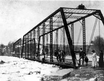
According to local landowners, the bridge was originally built on steel caissons. A historical photo from MDOT shown to the right shows an icy flood that reached the deck of this bridge. According to the landowners, the bridge was lifted off its caissons during the flood. It was however not destroyed. New concrete piers and abutments were constructed, several feet higher than the caissons, and the bridge was placed back upon this new substructure. A bridge inspection was conducted by F. Yeager Bridge and Culvert Company of Port Huron, Michigan in 1969. This, along with a 1969 county bridge record lists all components of the bridge as being in "fair" condition. It notes some cracking in the abutment wingwalls. At that time, the bridge was posted for a 4 ton weight limit. The bridge was permanently closed to all traffic on May 19, 1983.
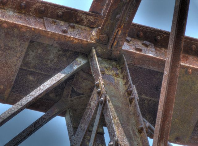
Overall, the bridge is traditionally composed, with v-lacing on the verticals, struts (sway bracing) and lattice on portals giving this bridge a geometric beauty. The bridge has pinned connections, with fairly massive eyebars for the bottom chord that are the up-set variety. Some of the diagonal member eyebars are up-set as well, while the remaining diagonals as well as the hip verticals are loop-forged eyebars. The top chord and end post are composed of back-to-back channels of cover plate and battens. The vertical members are back-to-back channels with v-lacing on each size. The depth of the vertical member channels is not the same for each vertical. The deeper channels were rolled by Lackawanna, while Carnegie rolled the shallower channels. A Jones and Laughlin label was found on the channels that form the outer edge of the deck stringer system. The floorbeams are rolled American Standard Beams. The struts are two pairs of angles with v-lacing sandwiched between the pairs, and single angle knees. The portal bracing and the portal bracing knees are composed of paired angles with lattice web sandwiched between.

Today, the bridge trusses themselves retain excellent historic integrity. The only major alteration to the truss is the replacement of the original bottom chord pin plates which connect the pin to the vertical members. These were replaced with welded plate. Some of the pipe railing has been damaged and is missing. Original plaques, including a portal mounted plaque and an endpost mounted plaque are missing. Structurally, the truss overall appears to be in good condition. Particularly surprising is the striking lack of section loss and pack rust in the bottom chord connections, a traditional trouble spot. Because of this, restoration of this bridge would likely cost less and require less replacement of original bridge material than many similar historic truss bridges might need.
The bridge has two 10 panel through truss spans with a 148' clear span providing an overall length of 299' 10.5". The bridge's overall width is 16' 0.5", the roadway width is 13' 4.5", the truss height is 19' 6", the underclearance is 14' 6". The bridge has two pipes for railing with diameter of 1-5/8". Each truss panel is 14' 11". The bridge has 15" floorbeams. The deck stringer system includes 2 6" x 2" channel fascia beams and 6 6" x 3-1/4" I-beams spaced 26" apart. The bridge's pins are 3" in diameter. The deck contains 3" x 10" wooden planks with 28" wooden running boards.
Indeed, this company's work has not been found in many places even outside of Michigan. The bridge sits on concrete abutments and piers. The deck is wooden. v-lacing is present on the sway bracing and vertical members. The portal bracing is made of lattice. Railings on the bridge are original pole railings. These are damaged in some spots, mainly on the east end of the bridge. The spans are ten panels each. This bridge's members and chords have a relatively massive feeling to them, likely due to the bridge's relatively late (for pin-connected truss bridges) 1909 construction date and also the large 150 foot spans.
This bridge is tagged with the following special condition(s): Available and Unorganized Photos
![]()
Photo Galleries and Videos: Goodwin Road Bridge
Original Bridge Photo-Documentation
A collection of overview and detail photos, taken Summer 2005. This photo gallery contains a combination of Original Size photos and Mobile Optimized photos in a touch-friendly popup viewer.Alternatively, Browse Without Using Viewer
![]()
2011 Bridge Details and HDR
Original / Full Size PhotosA collection of overview HDR photos and an expanded collection of detail photos, taken March 25, 2010. This gallery offers photos in the highest available resolution and file size in a touch-friendly popup viewer.
Alternatively, Browse Without Using Viewer
![]()
2011 Bridge Details and HDR
Mobile Optimized PhotosA collection of overview HDR photos and an expanded collection of detail photos, taken March 25, 2010. This gallery features data-friendly, fast-loading photos in a touch-friendly popup viewer.
Alternatively, Browse Without Using Viewer
![]()
Additional Unorganized Photos
Original / Full Size PhotosA supplemental collection of photos that are from additional visit(s) to the bridge and have not been organized or captioned. This gallery offers photos in the highest available resolution and file size in a touch-friendly popup viewer.
Alternatively, Browse Without Using Viewer
![]()
Additional Unorganized Photos
Mobile Optimized PhotosA supplemental collection of photos that are from additional visit(s) to the bridge and have not been organized or captioned. This gallery features data-friendly, fast-loading photos in a touch-friendly popup viewer.
Alternatively, Browse Without Using Viewer
![]()
Maps and Links: Goodwin Road Bridge
Coordinates (Latitude, Longitude):
Search For Additional Bridge Listings:
Bridgehunter.com: View listed bridges within 0.5 miles (0.8 kilometers) of this bridge.
Bridgehunter.com: View listed bridges within 10 miles (16 kilometers) of this bridge.
Additional Maps:
Google Streetview (If Available)
GeoHack (Additional Links and Coordinates)
Apple Maps (Via DuckDuckGo Search)
Apple Maps (Apple devices only)
Android: Open Location In Your Map or GPS App
Flickr Gallery (Find Nearby Photos)
Wikimedia Commons (Find Nearby Photos)
Directions Via Sygic For Android
Directions Via Sygic For iOS and Android Dolphin Browser
USGS National Map (United States Only)
Historical USGS Topo Maps (United States Only)
Historic Aerials (United States Only)
CalTopo Maps (United States Only)

