We Recommend:
Bach Steel - Experts at historic truss bridge restoration.
BridgeHunter.com Phase 1 is released to the public! - Visit Now
Hamilton Road Bridge
Allen County Bridge 242

Primary Photographer(s): Nathan Holth
Bridge Documented: April 2, 2006 and November 4, 2016
Rural: Allen County, Indiana and Huntington County, Indiana: United States
1883 By Builder/Contractor: Smith Bridge Company of Toledo, Ohio
1999
119.8 Feet (36.5 Meters)
120.7 Feet (36.8 Meters)
15.4 Feet (4.69 Meters)
1 Main Span(s)
200178

View Information About HSR Ratings
Bridge Documentation
View Archived National Bridge Inventory Report - Has Additional Details and Evaluation
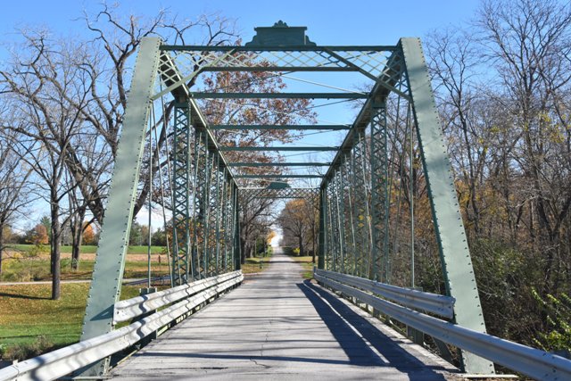
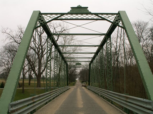
The structure is a seven panel pin connected Pratt through truss. There is v-lacing present on the vertical members. Original railings do not remain on the bridge, and have been replaced with modern Armco guardrails. With an 1883 construction date, the bridge is considerably old.
This bridge is similar to Michigan's Morseville Bridge. The Hamilton Road Bridge is a couple years older, and the last remaining finial on the endposts of this bridge shows that the finial style is slightly different, more square in appearance. In general however, both bridges are an example of what would have been a typical Smith Bridge Company metal truss bridge from the 1880s. The company's bridges often had finials on them, an undistinguished lattice portal bracing but with a distinctive positioning on the truss because it ends short of the top chord, making it look more offset from the top of the bridge than portal braces on bridges built by other companies. Perhaps the most unusual and distinctive detail found on this and other 1880s Smith Bridge Company metal truss bridges is the bearing and connection assembly. A specially shaped cast iron block is designed to accept an unusual threaded rod with nut connection for the ends of the bottom chord. The company also created an unusual sort of bearing where the entire bottom end of the end post rests in a curved cradle portion of the cast iron block, allowing for a limited amount of rotation.
The Hamilton Road Bridge also is also noted for its intact built-up Fishbelly floor beams that include decorative cast iron caps on the ends... a distinctive detail that today can only be found on a few bridges by Smith Bridge Company.
The Smith Bridge Company was somewhat unusual because it was a major builder of wooden covered bridges, and later expanded its company to include metal truss bridges, while continuing to build wooden bridges if asked to. Many of the country's metal truss bridge builders started as metal bridge builders, and only ever built metal bridges. Smith Bridge Company's experience with wooden covered bridges and their design and function may have influenced some of the unusual thinking in the design details of the bridge, particularly the bearing assembly.
The photo gallery for this bridge has, at the end, some additional photos from James L. Cooper showing the bridge before a repainting project that had recently been completed when HistoricBridges.org first visited the bridge in 2006.
Information and Findings From DHPA Historic Bridge SurveyHistory of Bridge D. W. Dewitt and twenty-three others from Lafayette township petitioned the Allen County Board of Commissioners in April 1883 for a new bridge over Eight-mile Creek--later dredged into Rebecca Knight Drain--on the border with Huntington County. The petitioners must have been quite persuasive, for when the two Boards met together in May they received bids and awarded contracts for a new structure. Henry C. Paul won the contract for the stone abutments. The Smith Bridge Company of Toledo was the successful bidder of nine for the wrought iron superstructure for $3,092. Architectural Description Rods hang as the hip verticals on Smith's trusses. The intermediate verticals consist of three sizes of laced channels (6.5, 5.5, 4.75 in.), growing lighter toward midspan. Pairs of eyebars provide the diagonals and are countered in the three most central panels with adjustable cylindrical rods. Latticed and braced portal struts, struts between upper panel points (I beams riveted to pin plates), and lateral bracing (of round rod) help the trusses address the stresses of moving loads. U-bolted to the lower pins, variable-depth girder floor-beams support I-beam stringers which carry the asphalt-over-timber roadway. The trusses are now lined with a pair of channels as rails, although the original contract called wood hub railings. Finials decorate the portal entrances. The bridge maintains 17 feet of vehicular clearance above the roadway. Statement of Significance The two counties commissioners selected an important local mason to build the stone substructure and an important Ohio fabricator to design and erect the wrought iron superstructure for a long-used and previously-bridged crossing. The Pratt through trusses are among the oldest extant ones in the state. They retain their original members, including decoratively latticed portals and bracing and some of the entrance finials. References Butler, Fairman & Seufert, Inc., Bridge Inspection/Reinspection Report: Allen County (Indianapolis: 1973, 1977, 1981). SIECO, Inc., Bridge Reinspection Report: Allen County (Columbus, 1993, 1995). Bridge nameplate. Allen County, "Commissioners Record," R: 475-476, 531-534; S: 199, 243. Bridge Considered Historic By Survey: Yes |
This bridge is tagged with the following special condition(s): Unorganized Photos
![]()
Photo Galleries and Videos: Hamilton Road Bridge
2006 Bridge Photo-Documentation
Original / Full Size PhotosA collection of overview and detail photos. This gallery offers photos in the highest available resolution and file size in a touch-friendly popup viewer.
Alternatively, Browse Without Using Viewer
![]()
2006 Bridge Photo-Documentation
Mobile Optimized PhotosA collection of overview and detail photos. This gallery features data-friendly, fast-loading photos in a touch-friendly popup viewer.
Alternatively, Browse Without Using Viewer
![]()
2016 Additional Unorganized Photos
Original / Full Size PhotosA supplemental collection of photos that are from additional visit(s) to the bridge and have not been organized or captioned. This gallery offers photos in the highest available resolution and file size in a touch-friendly popup viewer.
Alternatively, Browse Without Using Viewer
![]()
2016 Additional Unorganized Photos
Mobile Optimized PhotosA supplemental collection of photos that are from additional visit(s) to the bridge and have not been organized or captioned. This gallery features data-friendly, fast-loading photos in a touch-friendly popup viewer.
Alternatively, Browse Without Using Viewer
![]()
Maps and Links: Hamilton Road Bridge
Coordinates (Latitude, Longitude):
Search For Additional Bridge Listings:
Bridgehunter.com: View listed bridges within 0.5 miles (0.8 kilometers) of this bridge.
Bridgehunter.com: View listed bridges within 10 miles (16 kilometers) of this bridge.
Additional Maps:
Google Streetview (If Available)
GeoHack (Additional Links and Coordinates)
Apple Maps (Via DuckDuckGo Search)
Apple Maps (Apple devices only)
Android: Open Location In Your Map or GPS App
Flickr Gallery (Find Nearby Photos)
Wikimedia Commons (Find Nearby Photos)
Directions Via Sygic For Android
Directions Via Sygic For iOS and Android Dolphin Browser
USGS National Map (United States Only)
Historical USGS Topo Maps (United States Only)
Historic Aerials (United States Only)
CalTopo Maps (United States Only)


