

View Information About HSR Ratings
As of 2021, this heritage bridge has been fully restored. This is a major success story for the area, and local leaders deserve to be thanked for choosing to preserve this beautiful bridge. B.M. Ross and Associates was the engineer, and the contractor was McLean Taylor Construction.
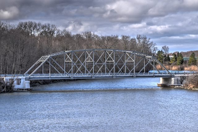
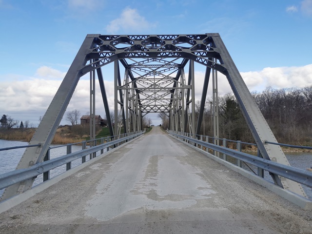
This visually appealing bridge is a beautiful example of the Parker truss configuration. The bridge is unusual because of its addition of horizontal members that make the bridge look somewhat like a Pennsylvania truss, although this bridge lacks the subdividing vertical members of an actual Pennsylvania truss. Smaller members on the bridge are built up using paired angles. The top chord and end post is also built-up, as are some diagonals. Other diagonal members and vertical members are rolled i-beams. There is v-lacing under the top chord, on the sway bracing, and on the members composing the portal bracing. Elsewhere, built-up beams use battens instead. In these terms the bridge is pretty simple looking in appearance, but it more than makes up for that with its complex truss configuration. The bridge is a seven panel structure, and it sits on concrete abutments. The deck is also concrete. Original pole railings are present on the bridge.
This bridge is only four miles east of the United States border, where there is a Marine City-Sombra Ferry across the St. Clair River. This is noteworthy because this is a bridge design that is unlike anything found in Michigan, which no longer has any surviving rivet-connected highway Parker truss bridges. Actually, seeing a truss bridge with paint on it and open to traffic alone is quite unlike Michigan as well! This bridge is located just south of the McKeough Floodway Dam, which presents another thing about Ontario compared to Michigan. Unlike the United States which locks things up, puts up cameras and no trespassing signs, and fences all over everything, here in Canada visitors will find that this dam was not fenced off! Rather, it is turned into a park, allowing it to be functional and also serve another purpose. The dam offers spectacular views of the bridge. By the way, the dam's purpose is to divert flood waters from heading south to Wallaceburg by damming up the river and diverting the excess water over to the St. Clair River via a man-made canal. As a result, it is only damming something if the water level gets too high. The dam was built in 1984. The Holt Line Bridge must have had some exciting times dealing with the full force of the spring flooding before the dam was around!
Wayne Brown emailed HistoricBridges.org and provided some local history:
The brown house that you see at the top of the hill is where I was raised. My parents built that house in 1947 and it was originally white with a blue roof. I was born that same year in the month of December. Construction for the bridge began in the spring of 1950 with Fleck Trucking preparing the raised roadway for access. The bridge was completed in 1951 with the date hand-written into the fresh cement on the north-side curb close to the west end of the bridge. This date is no longer distinquishable due to the deterioration of the cement. My dad's footprints are still recognizable in the center of the bridge's cement flooring. I started to school in September, 1952, crossing the Duthil Bridge ( the actual name of the bridge) to go to Duthil School. By the way, my great-grandfather, William Brown, ran what was called the Brown Ferry for many years at this point on the Sydenham River until the building of the Duthil Bridge. Based on a clipping I have from the Wallaceburg News , the steel work was done by the Sarnia Bridge Co., Weltham and Fuller of Strathroy the abutments, and the grading by Flight Construction Co. of Mooretown. The engineers for the construction were McCubbin, Brisco & Todgham of Chatham and the inspector was James Huey of Becher.

This bridge is tagged with the following special condition(s): Unorganized Photos
![]()

![]()
![]()
![]()
![]()
Coordinates (Latitude, Longitude):
Search For Additional Bridge Listings:
Additional Maps:
Google Streetview (If Available)
GeoHack (Additional Links and Coordinates)
Apple Maps (Via DuckDuckGo Search)
Apple Maps (Apple devices only)
Android: Open Location In Your Map or GPS App
Flickr Gallery (Find Nearby Photos)
Wikimedia Commons (Find Nearby Photos)
Directions Via Sygic For Android
Directions Via Sygic For iOS and Android Dolphin Browser

© Copyright 2003-2025, HistoricBridges.org. All Rights Reserved. Disclaimer: HistoricBridges.org is a volunteer group of private citizens. HistoricBridges.org is NOT a government agency, does not represent or work with any governmental agencies, nor is it in any way associated with any government agency or any non-profit organization. While we strive for accuracy in our factual content, HistoricBridges.org offers no guarantee of accuracy. Information is provided "as is" without warranty of any kind, either expressed or implied. Information could include technical inaccuracies or errors of omission. Opinions and commentary are the opinions of the respective HistoricBridges.org member who made them and do not necessarily represent the views of anyone else, including any outside photographers whose images may appear on the page in which the commentary appears. HistoricBridges.org does not bear any responsibility for any consequences resulting from the use of this or any other HistoricBridges.org information. Owners and users of bridges have the responsibility of correctly following all applicable laws, rules, and regulations, regardless of any HistoricBridges.org information.
![]()