We Recommend:
Bach Steel - Experts at historic truss bridge restoration.
BridgeHunter.com Phase 1 is released to the public! - Visit Now
Maple Road Bridge
Foster Bridge

Primary Photographer(s): Nathan Holth
Bridge Documented: April 16, 2004, March 13, 2005, October 9, 2009, and January 15, 2015
Ann Arbor Township: Washtenaw County, Michigan: United States
Metal 8 Panel Pin-Connected Pratt Through Truss, Fixed and Approach Spans: Wood Slab,
By Builder/Contractor: Wrought Iron Bridge Company of Canton, Ohio
2022
119.8 Feet (36.5 Meters)
150.0 Feet (45.7 Meters)
16 Feet (4.88 Meters)
1 Main Span(s) and 2 Approach Span(s)
81309H00019B010

View Information About HSR Ratings
Bridge Documentation
Note: The Historic Bridge Inventory lists an 1876 construction date for this bridge. However, HistoricBridges.org is not listing this because the 1876 patent date on early Wrought Iron Bridge Company bridge is often wrongly given as a construction date. It is not know how many (or even if) the company even built Pratt trusses to its patent in 1876, a year in which the company's iron bowstring bridges remained popular.
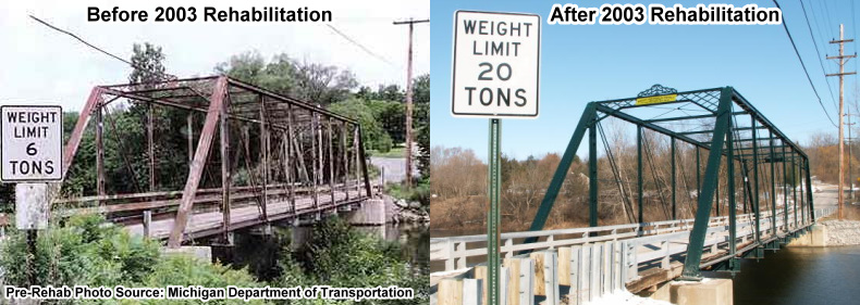
This bridge's comprehensive rehabilitation took place in 2003. In 2022, a repair and repainting project took place. The repairs were limited to drainage improvements. The overall wrought iron bridge remains in good condition, 19 years after the initial rehabilitation. This calls into serious question claims by states like Pennsylvania that a rehabilitated truss bridge will only offer another 25 years of service life. After 20 years, all this bridge needed was some paint. It should remain a functional crossing for many years to come without major rehabilitation, especially if the county continues to perform maintainance like this.
View Archived National Bridge Inventory Report - Has Additional Details and Evaluation
View An Article By Washtenaw County Road Commission Detailing Bridge Rehabilitation
About This Bridge
The Maple Road Bridge is also known locally as the Foster Bridge.
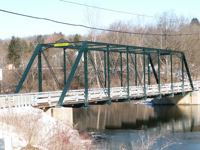
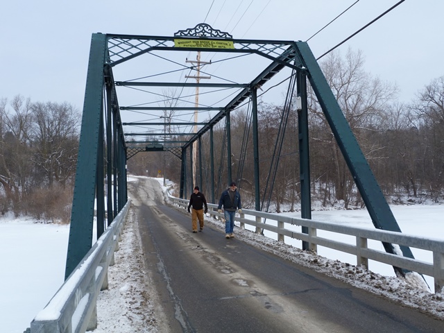
This is an old bridge, and its exact construction date is unknown, but HistoricBridges.org believes it dates to ca. 1880 based on style. This bridge displays many of the typical details of an early Wrought Iron Bridge Company through truss including vertical members lacking v-lacing or lattice, an unusual horizontal rod running through the middle of each truss web, lattice portal bracing, plaque that displays patent date but no construction date, and decorative portal cresting on top.
The Digital Bridges website has scans of a Wrought Iron Bridge Company pamphlet advertising the bridges the company sold, including one similar (but not identical) to the Maple Road Bridge. Click here to see the picture. The portal bracing is the same, as well as the plaque. The big difference is the bridge in the pamphlet has a decorative cast iron cap on the top of the end posts. This would have covered up an uncommon (and somewhat unsightly) connection design the company sometimes used at this point where the tension members are connected to the end post/top chord via a threaded rod with nut connection, rather than the traditional method of having a pin connection (like those used on the rest of the truss). The Maple Road Bridge does not use this and instead has a traditional pin connection at this point. This may suggest that the Maple Rapids Road Bridge was built ca. 1880, rather than ca. 1876, since the threaded rod with nut design is a more archaic design, and the traditional pin connection on Maple Road would have been the expected evolution away from the archaic design.
2003 Rehabilitation: An Example To Follow

Prior to 2003, this bridge had deteriorated to a point that it had a posted 6 ton weight limit. In 2003, the bridge was rehabilitated for $525,000 and following rehabilitation, the bridge was posted for an impressive 20 ton weight limit. It should be noted that prior to rehabilitation, the county had investigated demolition and replacement costs. Estimates ranged from 1,000,000 and went up to 4,000,000. This is a common occurrence with historic metal truss bridges: a well-designed rehabilitation of a metal truss bridge often costs less than it would cost to demolish and replace the bridge. Also, with a well-designed rehabilitation, the rehabilitated bridge often can be expected to offer a service life similar to that of a modern bridge. Indeed, the literature produced by the county about the Maple Road Bridge's rehabilitation suggest that the bridge could be looking at another 100 years of service life following the 2003 rehabilitation.
This bridge is an outstanding example of one of the many different ways that a historic metal truss bridge can be rehabilitated and preserved. This particular bridge demonstrates the use of post-tensioning in the rehabilitation of pin-connected truss bridges. Post-tensioning involves adding cables to take on tension forces in the bridge, normally taken on by diagonal member eyebars and the bottom chord eyebars. At the Maple Road Bridge, this solution greatly increased the weight limit for the bridge, while still retaining a large quantity of original bridge material.
Also worth noting are the modern guardrails added to the bridge. The two tube metal guardrails are relatively low profile so that they do not obstruct the view of the bridge, yet are designed and mounted to the bridge in a manner that the historic trusses are protected from damage by vehicle impact. During a rehabilitation of this type, if original railings remain on the bridge it is preferred that they be left in place behind the modern guardrails. This bridge does not retain original railings, but it appears they had already been lost by the time the 2003 rehabilitation occurred.
The main significant downside to this form of rehabilitation is the added post-tensioning system of cables. While they do not greatly distract from or obstruct the view of the original tension members, the added post-tensioning is visible. Some engineers might be bothered that the bridge is not functioning exactly as originally designed, since the added cables are taking the tension forces on the bridge. On the other side of the coin, historians more interested in original bridge materials and preserving the craftsmanship behind them likely find this an excellent solution, since if the post-tensioning had not been used, it is likely that the original tension eyebars would have been replaced to bring the bridge up to the desired weight limit. Each bridge and its needs for traffic are unique and so the appropriate form of rehabilitation varies. In this case, HistoricBridges.org believes that the type of rehabilitation done here was an excellent choice for this bridge and location.
This bridge is tagged with the following special condition(s): Unorganized Photos
![]()
Photo Galleries and Videos: Maple Road Bridge
Structure Overview
Original / Full Size PhotosA collection of overview photos that show the bridge as a whole and general areas of the bridge. This gallery offers photos in the highest available resolution and file size in a touch-friendly popup viewer.
Alternatively, Browse Without Using Viewer
![]()
Structure Details
Original / Full Size PhotosA collection of detail photos that document the parts, construction, and condition of the bridge. This gallery offers photos in the highest available resolution and file size in a touch-friendly popup viewer.
Alternatively, Browse Without Using Viewer
![]()
Structure Overview
Mobile Optimized PhotosA collection of overview photos that show the bridge as a whole and general areas of the bridge. This gallery features data-friendly, fast-loading photos in a touch-friendly popup viewer.
Alternatively, Browse Without Using Viewer
![]()
Structure Details
Mobile Optimized PhotosA collection of detail photos that document the parts, construction, and condition of the bridge. This gallery features data-friendly, fast-loading photos in a touch-friendly popup viewer.
Alternatively, Browse Without Using Viewer
![]()
Additional Unorganized Photos
Original / Full Size PhotosA supplemental collection of photos that are from additional visit(s) to the bridge and have not been organized or captioned. This gallery offers photos in the highest available resolution and file size in a touch-friendly popup viewer.
Alternatively, Browse Without Using Viewer
![]()
Additional Unorganized Photos
Mobile Optimized PhotosA supplemental collection of photos that are from additional visit(s) to the bridge and have not been organized or captioned. This gallery features data-friendly, fast-loading photos in a touch-friendly popup viewer.
Alternatively, Browse Without Using Viewer
![]()
Maps and Links: Maple Road Bridge
Coordinates (Latitude, Longitude):
Search For Additional Bridge Listings:
Bridgehunter.com: View listed bridges within 0.5 miles (0.8 kilometers) of this bridge.
Bridgehunter.com: View listed bridges within 10 miles (16 kilometers) of this bridge.
Additional Maps:
Google Streetview (If Available)
GeoHack (Additional Links and Coordinates)
Apple Maps (Via DuckDuckGo Search)
Apple Maps (Apple devices only)
Android: Open Location In Your Map or GPS App
Flickr Gallery (Find Nearby Photos)
Wikimedia Commons (Find Nearby Photos)
Directions Via Sygic For Android
Directions Via Sygic For iOS and Android Dolphin Browser
USGS National Map (United States Only)
Historical USGS Topo Maps (United States Only)
Historic Aerials (United States Only)
CalTopo Maps (United States Only)


