

View Information About HSR Ratings
Barry County bypassed this historic truss bridge with a modern structure and restored the historic bridge, creating an attractive park around it. They also had an official Michigan Historic Site plaque put up. This represents a pleasing solution to maintaining an efficient road system, retaining structures with significant historic value, and also creating a park for residents and visitors to enjoy. With this solution, everyone came out ahead. Barry County sets a good example for future bridge preservation projects elsewhere.
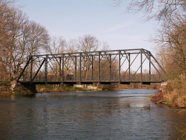
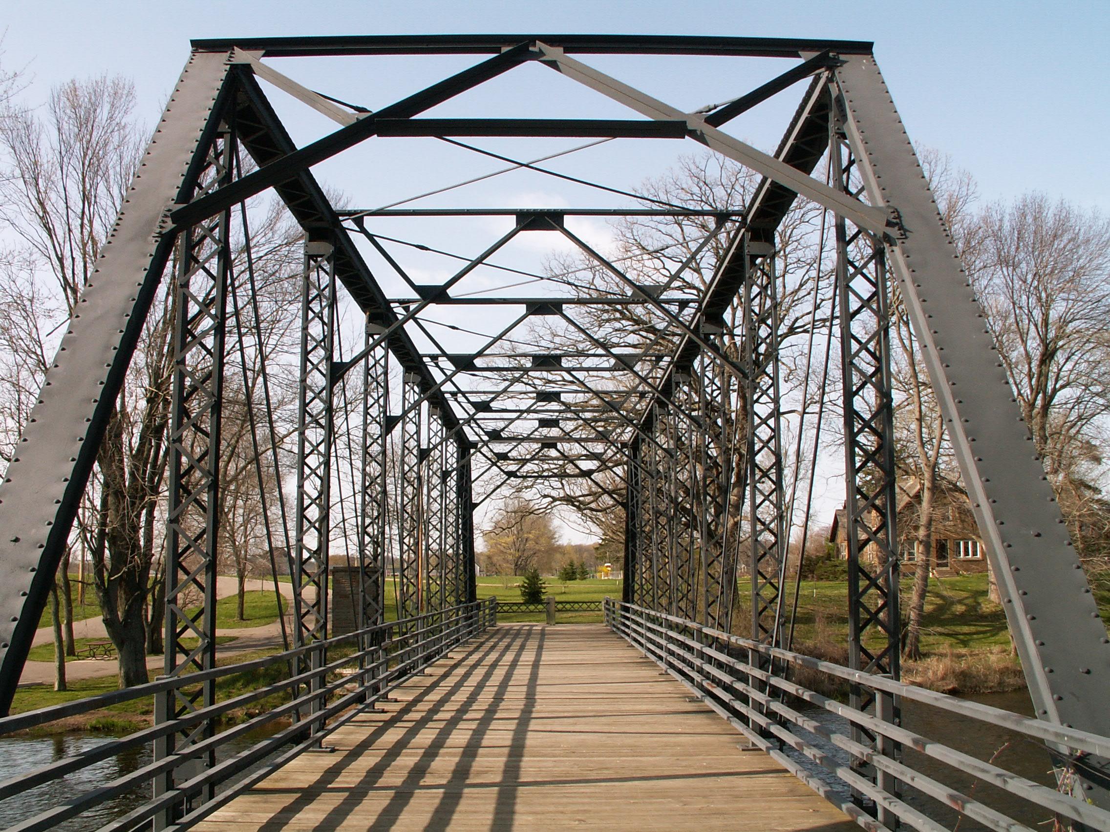
This bridge is a Pratt through truss with pinned connections. The bridge is composed of eight panels. An unusual characteristic of the bridge is that the portal bracing is identical to the sway bracing. The design of the bracing is an a-frame design. V-lacing is present on the bridge under the top chord and end post as well as on the vertical members. The deck is wooden, and while the deck The abutments are stone, and appear to have been patched as part of the restoration.
According to MDOT's description, which was from before the bridge was restored, there are lattice guardrails on the bridge. Those were unfortunately removed when the bridge was rehabilitated. A couple panels of the lattice guardrails were reused as gates for this bridge. On the other hand, the modern railings placed on the bridge are not as detrimental to the historic appearance of the bridge as railings placed on many other restored truss bridges. However, there was no reason to strip the original railings off of the bridge. The Beyer Road Bridge has modern safety railings placed on the bridge, but the lattice railings were also left on behind the new ones.
Information and Findings From Michigan Historic Bridge InventoryDescription The McKeown Bridge, also called the Sponable Bridge, is located on
McKeown Road over the Thornapple River between Old M-79 and River Road
in Hastings Township of Barry County. It is a single span steel Pratt
through truss bridge 119 feet long, 16.5 feet wide, and approximately 13 feet
high from deck to the underside of the truss. The bridge's
superstructure is an eight panel steel truss with steel floor beams,
stringers and a transverse timber deck. The abutments which support the
bridge on either bank are of fieldstone. The bridge is painted black to
protect the steel. Lattice work highlights and braces the railings.
McKeown Road Bridge was built in 1903 by the Massillon, Ohio, Iron
Company for Hastings Township at a total cost of $2,865. About the McKeowen Road Bridge, From Michigan Historic Sites OnlineNarrative Description The McKeown Bridge, also called the Sponable Bridge, is located on McKeown Road over the Thornapple River between Old M-79 and River Road in Hastings Township of Barry County. A new concrete bridge is to be located across the Thornapple River one mile directly west of the McKeown Road Bridge. Construction begins in summer 1997. The land on the both banks west of the bridges is set aside for a public park. To the east, the land is privately owned. McKeown Road Bridge is a single span steel Pratt through truss bridge. The bridge is 119 feet long, 16 feet 6 inches wide, and approximately 13 feet high from the deck to the underside of the truss. The bridge's superstructure is an eight panel steel truss with steel floor beams, stringers and a transverse timber deck. The abutments which support the bridge on either bank are of fieldstone. The bridge is painted black to protect the steel. Lattice work highlights and braces the railings. McKeown Road Bridge was built in 1903 by the Massillon, Ohio, Iron Company for Hastings Township at an approximate cost of $2,090. Together with the fieldstone abutments constructed by the township to support the bridge, the total cost of the project was $2,865. Statement of Significance The McKeown Road Bridge is a
well-preserved example of a Pratt through truss bridge, once a common,
but now rapidly vanishing means of providing transportation over rivers
in the early twentieth century. The bridge is the only steel truss
bridge remaining in Barry County. Despite the area's history as a bridge
site, no bridge was then standing at the time the existing bridge was
proposed in 1902 to 1903. McKeown Road Bridge received its current,
official name during the 1930s when electric companies extended their
services to rural areas and developed a system of naming rural roads to
aid in servicing lines and billing customers. The road and bridge
received their name from C. J. McKeown, a local farmer, who owned the
former Sponable farm on the east side of the road north of the
Thornapple river. Marker Text McKEOWN ROAD BRIDGE This steel Pratt through truss bridge was erected for Hastings Township in 1903. The township contracted with the Massillon Bridge Company of Massillon, Ohio, for $2,090, to fabricate and erect the steel bridge. In operation from 1869 to the 1930s, the firm was a leading producer of metal truss highway bridges throughout the lower Great Lakes region. The McKeown Road Bridge is the last metal truss highway bridge in Barry County.
|
This bridge is tagged with the following special condition(s): Unorganized Photos
![]()
![]()
![]()
![]()
Coordinates (Latitude, Longitude):
Search For Additional Bridge Listings:
Bridgehunter.com: View listed bridges within 0.5 miles (0.8 kilometers) of this bridge.
Bridgehunter.com: View listed bridges within 10 miles (16 kilometers) of this bridge.
Additional Maps:
Google Streetview (If Available)
GeoHack (Additional Links and Coordinates)
Apple Maps (Via DuckDuckGo Search)
Apple Maps (Apple devices only)
Android: Open Location In Your Map or GPS App
Flickr Gallery (Find Nearby Photos)
Wikimedia Commons (Find Nearby Photos)
Directions Via Sygic For Android
Directions Via Sygic For iOS and Android Dolphin Browser
USGS National Map (United States Only)
Historical USGS Topo Maps (United States Only)
Historic Aerials (United States Only)
CalTopo Maps (United States Only)

© Copyright 2003-2025, HistoricBridges.org. All Rights Reserved. Disclaimer: HistoricBridges.org is a volunteer group of private citizens. HistoricBridges.org is NOT a government agency, does not represent or work with any governmental agencies, nor is it in any way associated with any government agency or any non-profit organization. While we strive for accuracy in our factual content, HistoricBridges.org offers no guarantee of accuracy. Information is provided "as is" without warranty of any kind, either expressed or implied. Information could include technical inaccuracies or errors of omission. Opinions and commentary are the opinions of the respective HistoricBridges.org member who made them and do not necessarily represent the views of anyone else, including any outside photographers whose images may appear on the page in which the commentary appears. HistoricBridges.org does not bear any responsibility for any consequences resulting from the use of this or any other HistoricBridges.org information. Owners and users of bridges have the responsibility of correctly following all applicable laws, rules, and regulations, regardless of any HistoricBridges.org information.
![]()