

View Information About HSR Ratings
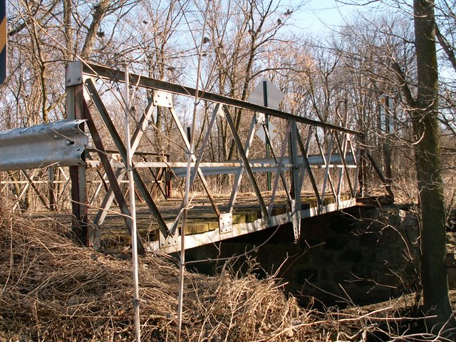
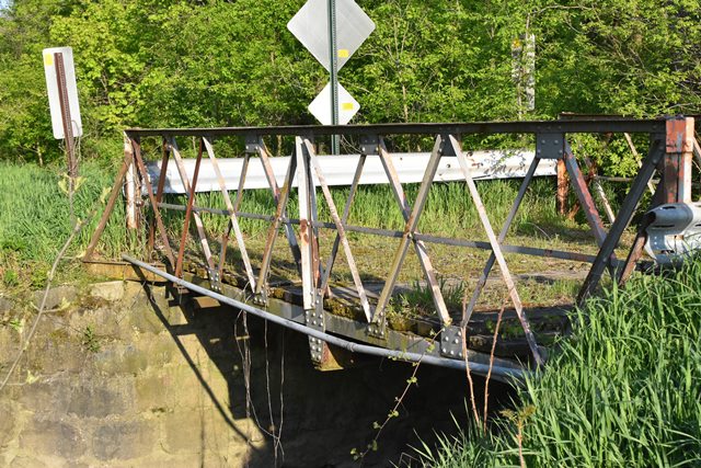
This truss bridge is a pony truss. It follows a double-intersection Warren truss design. It is a particularly unusual yet distinctive design that is noted for its extremely lightweight members and vertical end posts. Although rare, other examples of this style can be found elsewhere such as this Missouri example. This general design was a specific style of bridge marketed as a low cost alternative to heavier, more traditional bridge types. It is the only known example of its type in the state. Its connections are riveted, it has field stone abutments, and the deck is wood. It is currently closed to traffic. A fading layer of silver paint remains on the bridge, and rust is beginning to take over. The members are all very small. Composed of angles, no part of the bridge has v-lacing. There are no guardrails on the bridge.
This is a worthwhile bridge to preserve, since it is such an unusual type. If the county does not want to restore this bridge in place, the bridge could be relocated and preserved elsewhere. The bridge is so small and it would not be difficult to move. This bridge's strength is in its rarity, more so than its aesthetic qualities. As truss bridges go, this is a simply ornamented bridge. The bridge still appears to be in decent condition. The primary item of concern is the field stone abutments. While in good condition as of 2013, this type of abutment is notorious for falling apart since it is a low quality type of abutment that relies heavily on the mortar being in good condition, due to the random rubble nature of the stones.
Information and Findings From Michigan Historic Sites OnlineNarrative Description The Powers Highway Bridge, which is positioned on an east-west axis, is surrounded by farmland. The bridge carries Powers Highway, which is a short gravel road. Features of the bridge include: upper chord: back -to-back angles; bottom chord: channel section; vertical: back-to-back angles; diagonals: crossed angles which also serve as the lattice work railings; angle outriggers at corners; floor beam: I-beam bolted to superstructure; bottom laterals: crossed angles. Statement of Significance This structure appears to be the only one of its type in the survey. Lattice pony trusses are rare in Michigan. Numerous pony trusses were built according to the Pratt and Warren designs. A lattice pony truss was cheaper to build, because of the smaller members in the webs, but was not as strong as the Pratt or Warren. The 1910 date provided by the MDOT database seems plausible, given the design. No archival records could be found, but the bridge was probably built by the township, which would have been looking for the most economical design. The Powers Highway Bridge is eligible for the National Register under Criterion C because of its unusual design, which may be the only example in Michigan. |
This bridge is tagged with the following special condition(s): Unorganized Photos
![]()
![]()
![]()
![]()
![]()
Coordinates (Latitude, Longitude):
Search For Additional Bridge Listings:
Bridgehunter.com: View listed bridges within 0.5 miles (0.8 kilometers) of this bridge.
Bridgehunter.com: View listed bridges within 10 miles (16 kilometers) of this bridge.
Additional Maps:
Google Streetview (If Available)
GeoHack (Additional Links and Coordinates)
Apple Maps (Via DuckDuckGo Search)
Apple Maps (Apple devices only)
Android: Open Location In Your Map or GPS App
Flickr Gallery (Find Nearby Photos)
Wikimedia Commons (Find Nearby Photos)
Directions Via Sygic For Android
Directions Via Sygic For iOS and Android Dolphin Browser
USGS National Map (United States Only)
Historical USGS Topo Maps (United States Only)
Historic Aerials (United States Only)
CalTopo Maps (United States Only)

© Copyright 2003-2025, HistoricBridges.org. All Rights Reserved. Disclaimer: HistoricBridges.org is a volunteer group of private citizens. HistoricBridges.org is NOT a government agency, does not represent or work with any governmental agencies, nor is it in any way associated with any government agency or any non-profit organization. While we strive for accuracy in our factual content, HistoricBridges.org offers no guarantee of accuracy. Information is provided "as is" without warranty of any kind, either expressed or implied. Information could include technical inaccuracies or errors of omission. Opinions and commentary are the opinions of the respective HistoricBridges.org member who made them and do not necessarily represent the views of anyone else, including any outside photographers whose images may appear on the page in which the commentary appears. HistoricBridges.org does not bear any responsibility for any consequences resulting from the use of this or any other HistoricBridges.org information. Owners and users of bridges have the responsibility of correctly following all applicable laws, rules, and regulations, regardless of any HistoricBridges.org information.
![]()