We Recommend:
Bach Steel - Experts at historic truss bridge restoration.
BridgeHunter.com Phase 1 is released to the public! - Visit Now
Thamesville Bridge
Victoria Road Bridge

Primary Photographer(s): Nathan Holth
Bridge Documented: July 12, 2005, June 5, 2006, May 15, 2013, and September 17, 2018
Thamesville: Chatham-Kent Region, Ontario: Canada
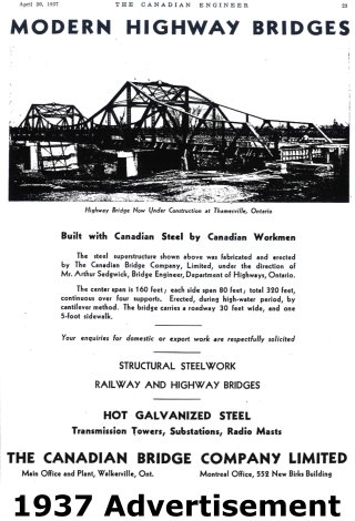
1937 By Builder/Contractor: Canadian Bridge Company of Walkerville, Ontario and Engineer/Design: Ontario Department of Highways
1980
160.0 Feet (48.8 Meters)
320.0 Feet (97.5 Meters)
30 Feet (9.14 Meters)
3 Main Span(s)
Not Applicable

View Information About HSR Ratings
Bridge Documentation
This bridge no longer exists!
Bridge Status: This unique, rare heritage bridge was demolished and replaced Fall 2019!Bridge Design and Significance
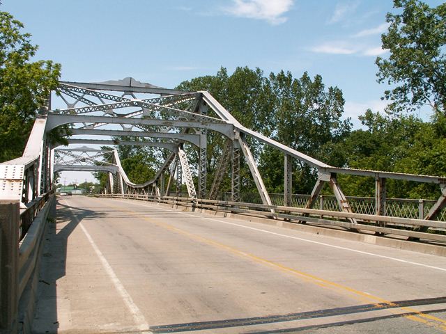
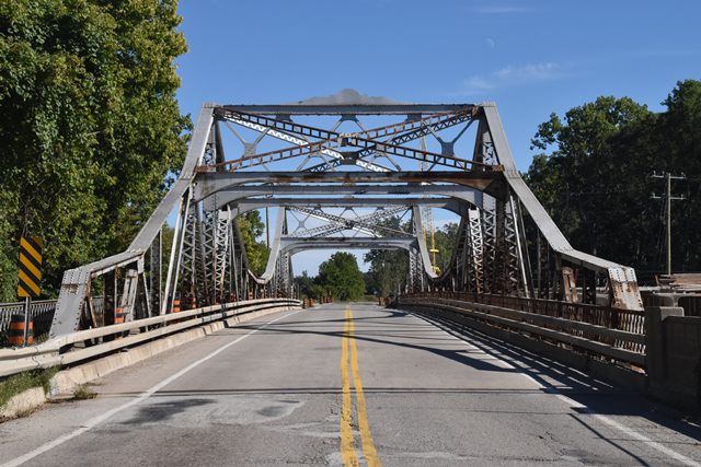
One of the most unique heritage bridges in Ontario and perhaps all of Canada is this unusual implementation of long-span bridge technology to a relatively short-span crossing. This bridge has the appearance of an unusually small cantilever truss bridge, with trusses that deepen to form towers around main posts at the bridge's two piers, while sloping down to become shallower trusses at the center and ends of the bridge. This bridge does not appear to be a true cantilever truss however, because no hinges or suspended spans are apparent in the structure. Rather, this is a bridge that was built using the cantilever method for construction, however once completed, it became a single rigid structure that functions as a continuous truss. Additional evidence of the continuous function is evident in the lack of any expansion joints anywhere but at the ends of the bridge. Both cantilever and continuous truss bridges that take the shape of this truss are generally reserved for long-span crossings. Indeed, the largest truss span in the world is Canada's Quebec Bridge, which is a cantilever truss. Finding a truss of this design at such a small scale as the Thamesville Bridge is very unusual.
The bridge retains excellent historic integrity. There are only two exceptions. The original plaques have gone missing on this bridge. There was a plaque on the overhead bracing. Also, on the end post, there was a standard Canadian Bridge Company plaque like the one found on the Shade Street Bridge. The other exception is that some of the northern overhead bracing has been replaced. It was likely damaged in a collision, perhaps by an over-height truck. This bracing was replaced by modern bolted beams. Otherwise, the bridge appears to be unaltered. Even elements that are not overly important in respect to the bridge's heritage value such as deck stringers and floor beams appear to be original. Original lattice railings remain in place behind modern vehicular railings. Original sidewalk lattice railings also remain in place. The bridge has a single sidewalk on the northeastern side.
This bridge is historically and technologically significant as a rare example of a continuous through truss, and more so one built using the cantilever method of construction. It is one of the last remaining metal truss bridges in extreme southwestern Ontario. Its small scale for a bridge of its type only adds to its rarity. No other similar bridge is known to exist in Ontario today.
The stone piers of a previous bridge remain immediately south of the truss bridge. A sign reading "1874" is mounted on a pier indicating when the previous bridge dated to.
Bridge Aesthetics
At the time this bridge was built, it likely was considered a utilitarian design. Decorative plaques on the overhead bracing, and minor details on the abutment concrete railing panels are the limits of purposeful architectural embellishment on the bridge. The appearance of the truss with two pointed towers was an aesthetic generally frowned upon at the time, and exactly what the Blue Water Bridge, a cantilever truss, was designed to avoid. Despite these facts, the Thamesville Bridge stands out as very beautiful in comparison to modern bridges. It is beautiful because it is unlike other bridges in existence today and is welcome variety in a world full of modern bridges that look like little more than slabs of concrete.
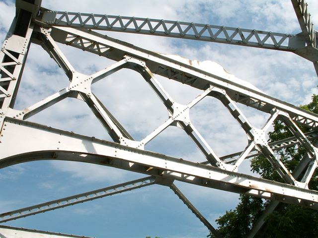
This bridge has a beauty derived from its trusses which form a uniquely complex geometric art. The Warren trusses themselves with their variable depth trusses that rise and fall above roadway form a geometry not found in most truss bridges. Furthermore, like many truss bridges from this period, the bridge is composed of riveted, built-up beams that have their own geometric art formed from details like v-lacing and lattice that hold the beams together. Modern steel used in building today lacks these details.
Demolition Risk
Despite the dwindling number of heritage bridges in this region of Ontario, and despite how unique this heritage bridge is, this bridge is at risk for demolition and replacement. To deny that this bridge exhibits deterioration would be ignoring the facts, yet to say that the bridge is not feasible to rehabilitate while maintaining the elements of the bridge that give it heritage significance would also be ignoring the facts.
This bridge deserves to be rehabilitated and preserved. The bridge could be rehabilitated for continued two-lane vehicular use. The bridge could also be bypassed by a modern bridge and left standing next to this replacement for pedestrian use. Finally, if there is a need to turn this road into a larger four lane highway, a new two lane bridge could be built next to the heritage bridge and the two bridges could form a one-way couplet of bridges.
Suggested rehabilitation of this bridge would be to repair section loss and pack rust on the bridge. Preferably, existing bridge members would be repaired, using techniques like pad welding and/or welding pieces of plate to build up areas of section loss, pneumatic methods of pack rust removal, etc. Failed or deteriorated rivets would preferably be replaced in-kind with rivets, although many projects compromise by using modern bolts instead even though riveting is neither costly nor difficult. If any truss web members were replaced in their entirety, they preferably would be replaced in-kind, replicating built-up member details like lattice and v-lacing.
Finally, it is worth noting that the sign for the Thames River at this bridge states that the Thames River is a Canadian Heritage River. In deciding the fate of this bridge, Chatham-Kent should not only look at how unique the bridge itself is, but also that this bridge is part of the reason why the Thames River is worth calling a heritage river. Demolishing and replacing this bridge would diminish the qualities of the Thames River that give it heritage value.
This bridge is tagged with the following special condition(s): Unorganized Photos
![]()
Photo Galleries and Videos: Thamesville Bridge
Structure Overview
Original / Full Size PhotosA collection of overview photos that show the bridge as a whole and general areas of the bridge. This gallery offers photos in the highest available resolution and file size in a touch-friendly popup viewer.
Alternatively, Browse Without Using Viewer
![]()
Structure Details
Original / Full Size PhotosA collection of detail photos that document the parts, construction, and condition of the bridge. This gallery offers photos in the highest available resolution and file size in a touch-friendly popup viewer.
Alternatively, Browse Without Using Viewer
![]()
Structure Overview
Mobile Optimized PhotosA collection of overview photos that show the bridge as a whole and general areas of the bridge. This gallery features data-friendly, fast-loading photos in a touch-friendly popup viewer.
Alternatively, Browse Without Using Viewer
![]()
Structure Details
Mobile Optimized PhotosA collection of detail photos that document the parts, construction, and condition of the bridge. This gallery features data-friendly, fast-loading photos in a touch-friendly popup viewer.
Alternatively, Browse Without Using Viewer
![]()
2018 Additional Unorganized Photos
Original / Full Size PhotosA supplemental collection of photos that are from additional visit(s) to the bridge and have not been organized or captioned. This gallery offers photos in the highest available resolution and file size in a touch-friendly popup viewer.
Alternatively, Browse Without Using Viewer
![]()
2018 Additional Unorganized Photos
Mobile Optimized PhotosA supplemental collection of photos that are from additional visit(s) to the bridge and have not been organized or captioned. This gallery features data-friendly, fast-loading photos in a touch-friendly popup viewer.
Alternatively, Browse Without Using Viewer
![]()
Maps and Links: Thamesville Bridge
This historic bridge has been demolished. This map is shown for reference purposes only.
Coordinates (Latitude, Longitude):
Search For Additional Bridge Listings:
Additional Maps:
Google Streetview (If Available)
GeoHack (Additional Links and Coordinates)
Apple Maps (Via DuckDuckGo Search)
Apple Maps (Apple devices only)
Android: Open Location In Your Map or GPS App
Flickr Gallery (Find Nearby Photos)
Wikimedia Commons (Find Nearby Photos)
Directions Via Sygic For Android
Directions Via Sygic For iOS and Android Dolphin Browser


