

View Information About HSR Ratings
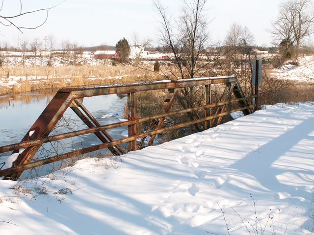
The bridge is a Warren pony truss of traditional composition. It is composed of three panels. Connections on the bridge are riveted, and no v-lacing is present on the bridge. Double channel style railings are present on the bridge. Jones and Laughlin steel brands were located on the bridge. That the company was going by the name "Laughlin" and not "Laughlins" indicates the steel dates to after 1905. A ca. construction 1910 date for this bridge might be accurate.
This bridge, which had been closed to traffic and essentially abandoned and was just sitting around minding its own business was demolished by the county for no reason other than to wipe it off the face of the earth. That's right, they did not build a new bridge in its place, they just demolished the bridge. This was a waste of both tax payer dollars and history. The bridge was not a hazard, it did not appear to be on the verge of collapse. To make matters worse, the road commission made no attempt to offer this bridge publicly to interested parties for preservation at another location. While this marketing method does not work anyway, at least there is a remote chance somebody hears about it. With a bridge this size, it would be easy to move and preserve. It would have made a great foot bridge in a park or on a trail.
![]()
![]()
![]()
This historic bridge has been demolished. This map is shown for reference purposes only.
Coordinates (Latitude, Longitude):
Search For Additional Bridge Listings:
Bridgehunter.com: View listed bridges within 0.5 miles (0.8 kilometers) of this bridge.
Bridgehunter.com: View listed bridges within 10 miles (16 kilometers) of this bridge.
Additional Maps:
Google Streetview (If Available)
GeoHack (Additional Links and Coordinates)
Apple Maps (Via DuckDuckGo Search)
Apple Maps (Apple devices only)
Android: Open Location In Your Map or GPS App
Flickr Gallery (Find Nearby Photos)
Wikimedia Commons (Find Nearby Photos)
Directions Via Sygic For Android
Directions Via Sygic For iOS and Android Dolphin Browser
USGS National Map (United States Only)
Historical USGS Topo Maps (United States Only)
Historic Aerials (United States Only)
CalTopo Maps (United States Only)

© Copyright 2003-2025, HistoricBridges.org. All Rights Reserved. Disclaimer: HistoricBridges.org is a volunteer group of private citizens. HistoricBridges.org is NOT a government agency, does not represent or work with any governmental agencies, nor is it in any way associated with any government agency or any non-profit organization. While we strive for accuracy in our factual content, HistoricBridges.org offers no guarantee of accuracy. Information is provided "as is" without warranty of any kind, either expressed or implied. Information could include technical inaccuracies or errors of omission. Opinions and commentary are the opinions of the respective HistoricBridges.org member who made them and do not necessarily represent the views of anyone else, including any outside photographers whose images may appear on the page in which the commentary appears. HistoricBridges.org does not bear any responsibility for any consequences resulting from the use of this or any other HistoricBridges.org information. Owners and users of bridges have the responsibility of correctly following all applicable laws, rules, and regulations, regardless of any HistoricBridges.org information.
![]()