HistoricBridges.org Menu: HistoricBridges.org Menu:


We Recommend:
Bach Steel - Experts at historic truss bridge restoration.

HistoricBridges.org: Bridge Browser

Aldwark Bridge

Aldwark Bridge

Primary Photographer(s): Nathan Holth

Bridge Documented: May 12, 2018

View Photos
and Videos
View Maps
and Links

Facility Carried / Feature Intersected
Boat Lane Over River Ure (River Ouse)
Location
Aldwark: Yorkshire and the Humber, England: United Kingdom
Structure Type
Metal Lattice Through Girder, Fixed and Approach Spans: Brick Segmental Deck Arch,
Construction Date and Builder / Engineer
1880 By Builder/Contractor: Unknown
Rehabilitation Date
Not Available or Not Applicable
Main Span Length
50.0 Feet (15.2 Meters)
Structure Length
750.0 Feet (228.6 Meters)
Roadway Width
Not Available
Spans
4 Main Span(s)
Inventory Number
Not Applicable

Historic Significance Rating (HSR)
View Information About HSR Ratings

Bridge Documentation

View the Official Website For This Bridge

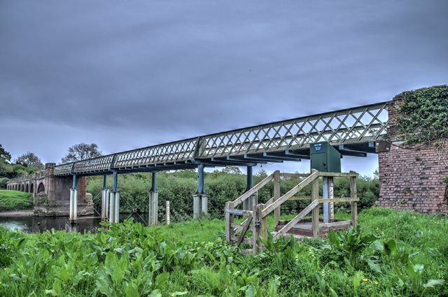
Construction date given is an estimated ca. date. The main spans of a bridge at this location was washed away in a flood in 1880, so it is assumed the lattice girder seen here dattes to soon after that flood. The arch approach spans may in part be older, if they were from this earlier bridge and they survived the flood. They could date to the 1700s.

Official Heritage Listing Information and Findings

Listed At: Grade II

Discussion:

List Entry Number: 1150281

Tollbridge. Mid C18, part replaced in late C19. Iron-framed bridge with timber decking, and one surviving brick arch on sandstone cutwater; floodarches red brick in loose English garden wall bond with sandstone dressings; sandstone and brick abutment walls and piers on Aldwark bank. Flat 4-span bridge on tall slender columns flanked by semicircular brick arches between pilaster piers with round-arched recessed panels. Arch on Aldwark side is skewed and spans part of river. Arcades of semicircular floodarches between pilaster piers and with flat, tooled coping, on each bank. Arcade on Aldwark bank terminates in splayed walls with flat coping, ramped up from piers with flat caps. Bridge statute approved in 1768; centre part washed away in flood of 1880.

Divider

Photo Galleries and Videos: Aldwark Bridge


View Photo Gallery

Bridge Photo-Documentation

Original / Full Size Photos
A collection of overview and detail photos. This gallery offers photos in the highest available resolution and file size in a touch-friendly popup viewer.
Alternatively, Browse Without Using Viewer

Divider

View Photo Gallery

Bridge Photo-Documentation

Mobile Optimized Photos
A collection of overview and detail photos. This gallery features data-friendly, fast-loading photos in a touch-friendly popup viewer.
Alternatively, Browse Without Using Viewer

Divider

View Video

OOPS!!!

Full Motion Video
Two people going different directions tried to cross the one-lane bridge at the same time. Here is what happened. Streaming video of the bridge. Also includes a higher quality downloadable video for greater clarity or offline viewing.

Divider

Maps and Links: Aldwark Bridge

Coordinates (Latitude, Longitude):

Search For Additional Bridge Listings:

HistoricBridges.org Bridge Browser: View listed bridges within 0.5 miles (0.8 kilometers) of this bridge.

HistoricBridges.org Bridge Browser: View listed bridges within 10 miles (16 kilometers) of this bridge.

Additional Maps:

Google Maps

Google Streetview (If Available)

Bing Maps

OpenStreetMap

GeoHack (Additional Links and Coordinates)

Apple Maps (Via DuckDuckGo Search)

Apple Maps (Apple devices only)

MapQuest

HERE We Go Maps

ACME Mapper

Waze Map

Android: Open Location In Your Map or GPS App

Flickr Gallery (Find Nearby Photos)

Wikimedia Commons (Find Nearby Photos)

Directions Via Sygic For Android

Directions Via Sygic For iOS and Android Dolphin Browser

Ordnance Survey Maps (UK Only)


Divider
 
Home Top

Divider

About - Contact

© Copyright 2003-2024, HistoricBridges.org. All Rights Reserved. Disclaimer: HistoricBridges.org is a volunteer group of private citizens. HistoricBridges.org is NOT a government agency, does not represent or work with any governmental agencies, nor is it in any way associated with any government agency or any non-profit organization. While we strive for accuracy in our factual content, HistoricBridges.org offers no guarantee of accuracy. Information is provided "as is" without warranty of any kind, either expressed or implied. Information could include technical inaccuracies or errors of omission. Opinions and commentary are the opinions of the respective HistoricBridges.org member who made them and do not necessarily represent the views of anyone else, including any outside photographers whose images may appear on the page in which the commentary appears. HistoricBridges.org does not bear any responsibility for any consequences resulting from the use of this or any other HistoricBridges.org information. Owners and users of bridges have the responsibility of correctly following all applicable laws, rules, and regulations, regardless of any HistoricBridges.org information.

Admin Login

Divider