Disclaimer: Generated with the aid of ChatGPT AI, the below narrative is based on sources provided by Nathan Holth (which are available for download below) and crafted to align with his research and passion for historic bridges.
The Clifton Suspension Bridge: A Legacy of Engineering Excellence
The Clifton Suspension Bridge, spanning the Avon Gorge in Bristol, England, is an enduring testament to visionary engineering and architectural ingenuity. The idea of a bridge at this location dates back to the 18th century when William Vick, a Bristol alderman, left a bequest of £1,000 to fund its construction. His vision was for a stone bridge, but by the 19th century, technological advancements led to the preference for a suspension bridge.
Early Vision and Funding Challenges
In 1753, Vick's will stipulated that his bequest should accumulate interest until it reached a sufficient amount to build a bridge. However, it took decades before the funds had grown significantly, and by the time serious discussions began in the early 19th century, the cost of construction had far exceeded the available capital. Recognizing the public importance of the project, the Society of Merchant Venturers of Bristol took on the responsibility of overseeing its realization.
A competition was held in 1829 to determine the best design for the bridge. Several engineers, including the renowned Thomas Telford, submitted proposals. Telford, who was a strong advocate of stone construction, suggested a design that was deemed unsuitable for the dramatic setting of the Avon Gorge. Isambard Kingdom Brunel, a rising star in British engineering, initially submitted a proposal that was rejected. However, in 1831, a revised version of his design was accepted, and construction commenced.
Construction Begins and Stalls
The bridge's foundation stone was laid on June 20, 1831, in a grand ceremony attended by numerous dignitaries. The occasion was marked by speeches emphasizing the bridge's expected benefits, both economic and social. However, political unrest in Bristol later that year, including the Bristol Riots, disrupted progress, and the project soon ran into financial difficulties.
Over the next two decades, repeated efforts were made to raise the necessary funds, but various challenges—including the enormous cost of materials and labor—continued to hinder progress. In 1843, work on the bridge was suspended indefinitely, leaving only the towers and some foundational work completed.
The Revival and Completion
The breakthrough came in 1860 when an opportunity arose to repurpose materials from the Hungerford Suspension Bridge in London, which was being dismantled to make way for the expansion of Charing Cross Railway Station. The Clifton Suspension Bridge Company was formed in 1861, and construction resumed under the guidance of engineers John Hawkshaw and William Henry Barlow, who adapted Brunel’s original design to fit the available materials.
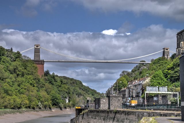
Structurally, the bridge has a main span of 702 feet (214 meters) between its towers, making it one of the longest suspension bridges of its time. The deck stands 245 feet (75 meters) above high water, allowing for unobstructed river traffic. Its chains, originally from the Hungerford Bridge, are composed of eye-bars fastened with pins, creating a robust and flexible system capable of handling substantial loads. The bridge's two towers, made of rough-faced gray granite, taper as they ascend, reducing weight while maintaining strength.
One of the bridge's most remarkable aspects is its ability to withstand extreme weather conditions. Despite lacking wind braces, the bridge has endured high winds and storms, sometimes swaying up to 18 inches during strong gales. Its maintenance has been rigorous over the years, with ongoing inspections and reinforcements to preserve its integrity.
Architectural Significance and Public Reception
When the bridge was finally completed, it was widely celebrated as an engineering marvel. The formal opening ceremony on December 8, 1864, was attended by thousands, including prominent engineers and public figures. The bridge immediately became a symbol of Bristol’s industrial progress and technological prowess.
Beyond its engineering feats, the Clifton Suspension Bridge has played a crucial role in Bristol's development. It has facilitated economic growth by improving connectivity between the city and surrounding regions. Additionally, the bridge has become a cultural and historical icon, attracting tourists and engineering enthusiasts from around the world. Its picturesque setting over the Avon Gorge, coupled with its elegant design, makes it one of the most photographed landmarks in England.
The Bridge Today
Today, the bridge remains a functioning toll bridge, with revenue used for maintenance and preservation. It continues to be a symbol of Bristol's rich history and technological progress. Over 150 years after its completion, the Clifton Suspension Bridge stands as a lasting tribute to the ambition and brilliance of Isambard Kingdom Brunel and the engineers who brought his vision to life.
Legacy and Influence
The Clifton Suspension Bridge has influenced the design of numerous suspension bridges worldwide. Its use of iron chains and suspension rods provided a model for later engineering projects. The bridge has been studied extensively by engineers and architects, who continue to admire its combination of strength, flexibility, and aesthetic beauty.
Over time, the bridge has undergone several renovation and preservation efforts. Advances in materials science and engineering have allowed for subtle improvements while maintaining the original design integrity. The bridge has been reinforced with modern safety measures, ensuring its continued use for generations to come.
Conclusion
From its origins as an ambitious idea in the 18th century to its realization in the 19th century and its enduring legacy into the 21st century, the Clifton Suspension Bridge remains an outstanding example of engineering triumph. It is not merely a crossing over the Avon Gorge but a monument to human ingenuity, perseverance, and the relentless pursuit of progress. Whether admired for its aesthetic grandeur or its technical brilliance, the bridge continues to inspire and captivate all who visit it.
Crossing the River Avon at a high level over a spectacular rocky gorge, this
amazing suspension bridge was designed by Brunel but not completed until after
his death. The official heritage listing information below offers a detailed
history.
If you visit this bridge, don't forget to visit the nearby
Brunel Swivel
Bridge, which was also designed by Brunel and was constructed when he was
still alive.
Official Heritage Listing Information and Findings
Listed At: Grade I
Discussion:
List Entry Number: 1205734
Summary
Suspension bridge across the Avon Gorge, designed 1829-31 by Isambard
Kingdom Brunel. Begun 1831. Second phase 1836-53. Completed 1860-4 by
Sir John Hawkshaw and William Henry Barlow.
Reasons for
Designation Clifton Suspension Bridge, designed in 1829-31 by IK
Brunel, and completed in 1860-4 by Sir John Hawkshaw and William Henry
Barlow, is listed at Grade I for the following principal reasons:
Architectural interest:
A remarkable engineering feat, spanning the Avon
Gorge over 214m, and 75m above high water using the suspension method;
*reuse of chains from Brunel’s Hungerford Bridge, demolished in 1860;
*substantially intact with little engineering intervention, despite
increased traffic load; *as a major landmark and icon within the Avon
Gorge and Bristol’s urban landscape.
Historic interest:
The major Bristol work of Isambard Kingdom Brunel;
*completed after Brunel’s death as a memorial to him.
History
On his death in 1753, Bristol alderman and wine merchant William Vick
left £1,000 to the Society of Merchant Venturers to fund the
construction of a toll-free stone bridge across the Avon Gorge between
Clifton Down and Leigh Woods. Although left to gather investment, by
1829 it was clear that the money raised was not enough to fulfil Vick’s
vision. An iron suspension bridge with a toll income was preferred and a
competition launched. The competition attracted 22 entries, including
four from the 23-year-old Isambard Kingdom Brunel. The final four
entries – one of which was Brunel’s – were judged by Thomas Telford.
Telford rejected them all, mainly over questions of wind stability, and
instead designed his own stone, three-span Gothic bridge; this failed to
attract funding.
An Act of Parliament was passed in May 1830 to
construct a tolled suspension bridge, and a second competition launched.
Twelve engineers submitted entries, again with Brunel submitting four
ideas. Five schemes were shortlisted, including one by Brunel, and the
others by Telford, Capt. Samuel Brown and James Meadows Rendel (both had
also entered the 1829 competition) and William Hawkes of the Eagle
Foundry in Birmingham. The judges, Davies Gilbert MP and John Seaward, a
civil engineer, preferred Hawkes’ design, and Brunel was placed second.
However, he made some alterations and convinced the judges that his
design was the only one to satisfy the weight considerations outlined in
the brief. On 16 March 1831 Brunel was appointed engineer, and estimated
the cost at £57,000 to include detailing in the then-fashionable
Egyptian style. The 214m-long span was to be 74.7m above high water,
suspended by a pair of double chains. He described the project in his
journal as ‘my first child, my darling’. The foundation stone on the
Clifton (east) side was laid on 21 June 1831, but little further
progress made before work was stalled by the Bristol Riots at the end of
October 1831.
Construction recommenced on 27 August 1836 with
the laying of the Leigh Woods (west) abutment foundation stone. In 1840
the chain manufacture contract with Copperhouse Foundry, Hayle was
signed. The towers, abutments and four anchor tunnels were completed by
1842, but by early 1843 funds ran out, with around £30,000 required for
much of the remaining ironwork construction. In October 1851 Brunel was
ordered to suspend work and sell the materials and plant to pay the
creditors. As such the chains were sold, and used in Brunel’s Royal
Albert Bridge, Saltash, Cornwall (1847-59; Grade I listed). Work was
completely abandoned in July 1853, by which time the time limit for
construction of the bridge as stipulated in the 1830 Act had elapsed.
Brunel died in September 1859.
In 1860, as a memorial to Brunel,
the Institute of Civil Engineers formed a company to complete the
bridge, with Sir John Hawkshaw and William Henry Barlow appointed as
engineers. The chains from Brunel’s Hungerford Suspension Bridge,
completed in 1845 and demolished in 1860 for the Charing Cross Railway,
were purchased and re-used at Clifton. Hawkshaw and Barlow’s changes to
Brunel’s design included the addition of a chain on each side of the
bridge; new anchor tunnels; reduced use of timber on the deck; and
rejection of the Egyptian theme, which would have seen the towers clad
in cast-iron decorative panels with sphinxes on top. Work continued,
until the bridge was finally opened in 8 December 1864 by the Lords
Lieutenant of Gloucestershire and Somerset.
Changes were made to
some of the ironwork and the decking into the C20. In 2002 an inspection
revealed that, despite appearing to be of solid sandstone construction,
the Leigh Woods abutment contains 12 vaulted chambers in two tiers,
linked by shafts and tunnels.
The asset was previously listed
twice also at List Entry 1129844.
Details MATERIALS Red
sandstone ashlar abutments, squared Pennant rubble pylons with ashlar
caps and limestone dressings. Wrought-iron chains and cast-iron
construction to the bridge deck.
DESCRIPTION Clifton Suspension
Bridge is supported on two large abutments, on the Clifton (east) and
Leigh Woods (west) sides of the Avon Gorge. The abutments are faced with
red sandstone ashlar, the west abutment being built into the sloping
bank and the smaller east abutment founded on the St Vincent’s Rocks
cliff top. The west abutment contains 12 vaulted rubble-stone chambers
over two tiers, each chamber around 11m high, linked by narrow shafts
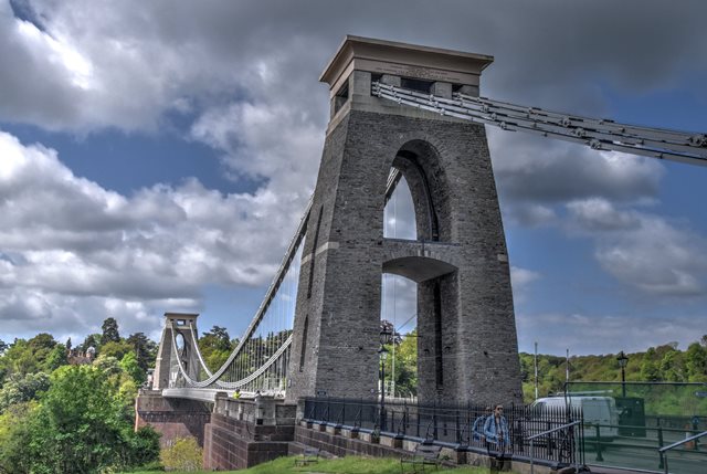
and tunnels. The bridge towers, each square in plan, are supported by
the abutments; the east tower is one metre taller than the west at
27.1m. The towers are constructed of Pennant sandstone rubble, with
ashlar caps and cornices and limestone dressings. Each is battered on
the north and south sides up to the segmental arch above the roadway,
but differ in that the east tower has narrow pointed-arch openings on
these elevations. Above the segmental arch a parabolic arch rises to
below the land chains. The tower caps have deep coved cornices; the cap
of the west tower carries the Latin inscription SUSPENSA VIX VIA FIT (‘a
suspended way made with difficulty’), and the east tower cap has the
inscription COMMENCED 1836 / ISAMBARD KINGDOM BRUNEL F.R.S. ENGINEER /
COMPLETED 1864 / JOHN HAWKSHAW F.R.S. WILLIAM HENRY BARLOW F.R.S.
ENGINEERS/ COCHRANE GROVE & CO CONTRACTORS. Each cap contains two
cast-iron saddles to which the chains are attached, mounted on rollers
to provide flexibility of movement between the land and central span
chains. The land chains are anchored into the ground on either side of
the Gorge across corresponding land saddles. The triple chains connect
to and support the deck with 162 suspension rods, each 2.4m apart and
varying in length. The six chains comprise 4,200 links across the entire
span of the bridge between the anchorages. The anchorages enter an
inclined tunnel at each end, locked by iron wedges behind cast iron
anchor plates, bolted to the rock. The deck is constructed of iron;
longitudinal girders are connected to the chains by suspension rods,
with cross girders with diagonal ties. The parallel footway parapets are
on the outside of the main structure, and have wrought iron lattice
girders which provide additional rigidity. The road itself is of Douglas
fir sleepers, covered with planking and asphalt. The span between the
towers is 214m (412m between the anchorages) and rises 74.7m above high
water, as Brunel intended. Recent analysis of the structure has proved
that Brunel’s design is close to the ideal.
The base of each
tower is surrounded by 1.2m-high coped, coursed rubble sandstone parapet
walls with ashlar piers. The walls extend beyond the west tower along
the roadway for approximately 46m on the north side and 91m on the
south.
At the west end of the bridge the road is flanked by two
single-storey toll houses, located at the end of the land chains. The
battered walls are constructed of coursed rubble sandstone with a
sandstone ashlar plinth, quoins and dressings, with a flat roof with an
overhanging moulded sandstone ashlar cornice. Inner elevations have a
single attached sandstone pier. Each tollhouse has a single door on the
west elevation, and a window on the outer elevations, set in deep
flat-section moulded architraves.
Pursuant to s1 (5A) of the
Planning (Listed Buildings and Conservation Areas) Act 1990 (‘the Act’)
it is declared that the two east tollhouses are not of special
architectural or historic interest.
Sources Books and journals
Andrews, A, Pascoe, M, Clifton Suspension Bridge, (2008) Foyle, A,
Pevsner Architectural Guides: Bristol, (2004), 85-87 Maggs, C,
Isambard Kingdom Brunel: the life of an engineering genius, (2017)
Pevsner, N, Foyle, A, The Buildings of England: Somerset: North and
Bristol, (2011), 329-330 Websites Brunel 200: Clifton Suspension
Bridge, accessed 20/02/2018 from http://www.brunel200.com/suspension_bridge.htm
Clifton Suspension Bridge, accessed 09/02/2018 from https://www.cliftonbridge.org.uk/
Engineering Timelines: Clifton Suspension Bridge, accessed 09/02/2018
from http://www.engineering-timelines.com/scripts/engineeringItem.asp?id=58
Know Your Place: Bristol, accessed 26/02/2018 from http://maps.bristol.gov.uk/kyp/?edition=
National Heritage List for England: Clifton Suspension Bridge (LE no:
1205734), accessed 09/01/2018 from https://historicengland.org.uk/listing/the-list/list-entry/1205734
National Heritage List for England: Clifton Suspension Bridge, two
tollhouses and flanking walls on west side (LE no: 1129844) - deleted,
accessed 09/01/2018 from https://historicengland.org.uk/listing/the-list/list-entry/1205734
Photo Galleries and Videos: Clifton Suspension Bridge
Original / Full Size Photos A collection of overview and detail photos. This gallery offers photos in the highest available resolution and file size in a touch-friendly popup viewer. Alternatively, Browse Without Using Viewer
Mobile Optimized Photos A collection of overview and detail photos. This gallery features data-friendly, fast-loading photos in a touch-friendly popup viewer. Alternatively, Browse Without Using Viewer