We Recommend:
Bach Steel - Experts at historic truss bridge restoration.
BridgeHunter.com Phase 1 is released to the public! - Visit Now
Craigellachie Bridge

Primary Photographer(s): Nathan Holth
Bridge Documented: May 14, 2018
Craigellachie: Moray, Scotland: United Kingdom
1814 By Builder/Contractor: Plas Kynaston Iron Foundry, of Cefn Mawr, Wales and William Hazledine of Shrewsbury, England and Engineer/Design: Thomas Telford
1964
150.0 Feet (45.7 Meters)
150.0 Feet (45.7 Meters)
Not Available
1 Main Span(s)
Not Applicable

View Information About HSR Ratings
Bridge Documentation
Visit the Friends of Craigellachie Bridge Website
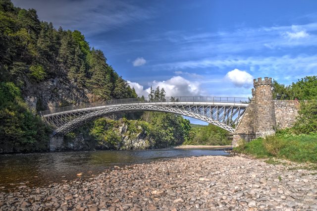
This beautiful bridge, bypassed and preserved for pedestrian use, is one of the most famous historic cast iron bridges in Scotland. Reportedly, it is the oldest iron arch bridge in Scotland. Its cast iron arch has the trademark design of a bridge designed by Thomas Telford including diamond lattice spandrel bracing and a heavy cast iron lattice arch rib.
One of the most unique and visually stunning features of the Craigellachie Bridge is the beautiful castellated towers on the abutments, which give this bridge an eye-catching feature not found on most cast iron arch bridges.
Unlike the similar (but younger) Mythe Bridge, the original cast iron spandrel bracing on the Craigellachie Bridge appears to have been replaced and/or altered, as welded connections and newer rolled steel (with Skinningrove England marks on them) are present. The original spandrel bracing design would have been cast iron with no welding present. Also unlike the Mythe Bridge, the railing on the Craigellachie Bridge is also not original. The cast iron arch ribs of this bridge remain original and appear unaltered however.
The bridge is owned by the Moray Council, but also enjoys the support of a local friends group.
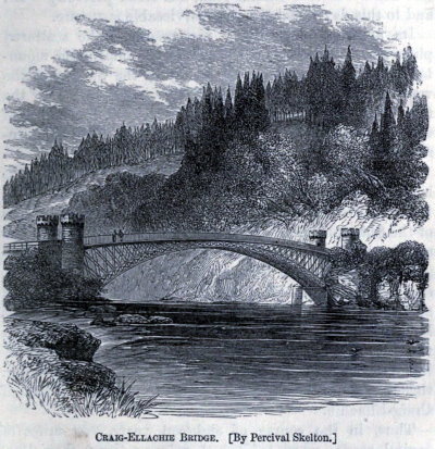
Above: Historical image of bridge in 1867 book The Life of Thomas Telford, by Samuel Smiles.
The following is a description of this bridge as it appeared in the Appendix of the 1838 autobiography of Thomas Telford.
CRAIGELLACHIE BRIDGE—The bridge over the river Spey at Fochabers was built by the Duke of Gordon about seventeen years since, partly at the expense of the public, and is maintained by tolls, not differing materially in the circumstances of its erection from Dunkeld bridge, excepting that it was not completed under our care. The utility of it was so strongly felt in the neighbourhood, that an application was made in the year 1810 for aid towards building a second bridge over the Spey at Boharm; but this being within six miles of Fochabers, we did not hold out much encouragement to the memorialists. Aware of the nature of our objection, they fixed on another site twelve miles above Fochabers, where the river Spey, rushing obliquely against the lofty rock of Craigellachie, has cut for itself a deep channel, not exceeding fifty yards in breadth. Over this an iron arch has been constructed, and is the more beautiful, from not being in immediate contact with masonry arches, as was necessary at Bonar. The scattered birch trees and native firs on the side of the impending mountain, the meadows along the valley of the Spey, and the western road of access to the bridge cut deeply into the face of the rock, combine, with the slender appearance of the iron arch, in rendering this spot one of the most remarkable in Scotland. Subsidiary to the main arch, and at some distance from it, are three others, built of stone, fifteen feet span each, under the eastern road of approach. These are useful in time of speats or river-floods, to which the Spey is remarkably liable. The entire price of this bridge, and its approaches, including the rock blasting on the west side of the river, was no more than £. 8,200; but we have to regret that the contractors, in ‘their zeal for the speedy and effectual accomplishment of their engagement, lost about £500 additional. This bridge was painted in 1818 at an expense of £130; and for parapets and railing along the eastern causeway of approach was expended above £100 last year.
Official Heritage Listing Information and FindingsListed At: Category A Discussion: Historic Environment Scotland Number: LB2357 (Undated) information in NMRS: |
![]()
Photo Galleries and Videos: Craigellachie Bridge
Bridge Photo-Documentation
Original / Full Size PhotosA collection of overview and detail photos. This gallery offers photos in the highest available resolution and file size in a touch-friendly popup viewer.
Alternatively, Browse Without Using Viewer
![]()
Bridge Photo-Documentation
Mobile Optimized PhotosA collection of overview and detail photos. This gallery features data-friendly, fast-loading photos in a touch-friendly popup viewer.
Alternatively, Browse Without Using Viewer
![]()
Maps and Links: Craigellachie Bridge
Coordinates (Latitude, Longitude):
Search For Additional Bridge Listings:
Additional Maps:
Google Streetview (If Available)
GeoHack (Additional Links and Coordinates)
Apple Maps (Via DuckDuckGo Search)
Apple Maps (Apple devices only)
Android: Open Location In Your Map or GPS App
Flickr Gallery (Find Nearby Photos)
Wikimedia Commons (Find Nearby Photos)
Directions Via Sygic For Android
Directions Via Sygic For iOS and Android Dolphin Browser
Ordnance Survey Maps (UK Only)


