We Recommend:
Bach Steel - Experts at historic truss bridge restoration.
BridgeHunter.com Phase 1 is released to the public! - Visit Now
Spey Viaduct
Speymouth Railway Viaduct

Primary Photographer(s): Nathan Holth
Bridge Documented: May 14, 2018
Railroad (Speyside Way Rail-Trail, Former Great North of Scotland Railway) Over River Spey
Garmouth: Moray, Scotland: United Kingdom
Metal Rivet-Connected Bowstring Through Truss, Fixed and Approach Spans: Metal Rivet-Connected Howe Pony Truss,
1885 By Builder/Contractor: Blaikie Brothers of Aberdeen, Scotland and Engineer/Design: Blyth and Cunningham and Patrick Barnett
Not Available or Not Applicable
350.0 Feet (106.7 Meters)
950.0 Feet (289.6 Meters)
Not Available
1 Main Span(s) and 6 Approach Span(s)
Not Applicable

View Information About HSR Ratings
Bridge Documentation

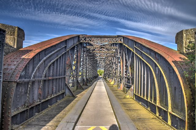
This bridge is noted for its amazing 350 foot clear span, which while not record-breaking, was nevertheless a notable achievement for a clear-span truss at this period in history. The impressive appearance of this bridge is enhanced by its heavy truss members, which are contrasted by the graceful curve of the bowstring design.
In UK/European vernacular, the approach spans for this bridge are often referred to as lattice girders, although it does not feature a dense lattice web like that found on a traditional lattice girder like the Koblenz Bridge. In American vernacular, these approach spans would be classified as a Howe pony truss. They would be considered a Howe rather than a Double-Intersection Warren because the diagonal members pointing to the top and center of the spans are the heavier members (two pairs of angle with lattice), with counter members being two simple plates/bars.
This bridge has today been converted for pedestrian use. The bridge is an impressive structure that is worth the walk to.
Official Heritage Listing Information and FindingsListed At: Category B Discussion: Historic Environment Scotland Number: LB14873 Statement of Special Interest
Canmore Notes: Built by Blaikie Bros, Aberdeen, in 1886 for the
Great North of Scotland Railway between Elgin and the Banffshire coast,
to a design by Patrick Barnett, this is an awe-inspiring iron structure
thrust between river and sky. This viaduct, built from 1883-86, was constructed to
carry the Moray Coast Railway, part of the Great North of Scotland
Railway, over the Spey and its floodplain 1 mile south of the coast. The
river crossing was initially conceived as three separate bridges
spanning the disparate channels, but it was decided to divert the river
into a single channel to be crossed on a viaduct with embankment
approaches. |
![]()
Photo Galleries and Videos: Spey Viaduct
Bridge Photo-Documentation
Original / Full Size PhotosA collection of overview and detail photos. This gallery offers photos in the highest available resolution and file size in a touch-friendly popup viewer.
Alternatively, Browse Without Using Viewer
![]()
Bridge Photo-Documentation
Mobile Optimized PhotosA collection of overview and detail photos. This gallery features data-friendly, fast-loading photos in a touch-friendly popup viewer.
Alternatively, Browse Without Using Viewer
![]()
Maps and Links: Spey Viaduct
Coordinates (Latitude, Longitude):
Search For Additional Bridge Listings:
Additional Maps:
Google Streetview (If Available)
GeoHack (Additional Links and Coordinates)
Apple Maps (Via DuckDuckGo Search)
Apple Maps (Apple devices only)
Android: Open Location In Your Map or GPS App
Flickr Gallery (Find Nearby Photos)
Wikimedia Commons (Find Nearby Photos)
Directions Via Sygic For Android
Directions Via Sygic For iOS and Android Dolphin Browser
Ordnance Survey Maps (UK Only)

