This is a large, very old, and intact example of a swing bridge, located in a
unique setting between two high level bridges which are also historic.
According to
Wikipedia's citation of an article by the Port of Tyne, "The hydraulic
power still used to move the bridge is today derived from electrically driven
pumps. These feed a hydraulic accumulator sunk into a 60 ft (18 m) shaft below the bridge; the water is then
released under pressure which runs the machinery to turn the bridge. The
mechanism used for this is still the same machinery originally installed by
Armstrong."
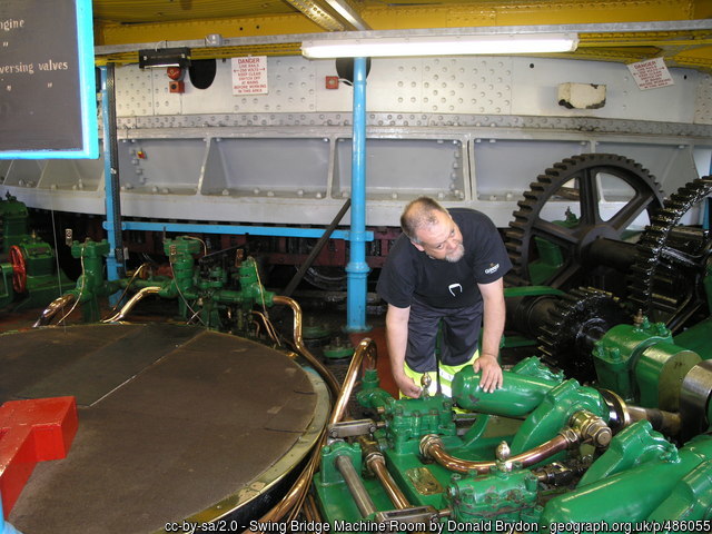
HistoricBridges.org's photo-documentation is extensive for this bridge, yet
lacks views from inside the swing pier. A few guest photos provided below offer
views inside the swing pier and allow views of the machinery of the bridge.
Above: A view of the rollers inside the swing pier.
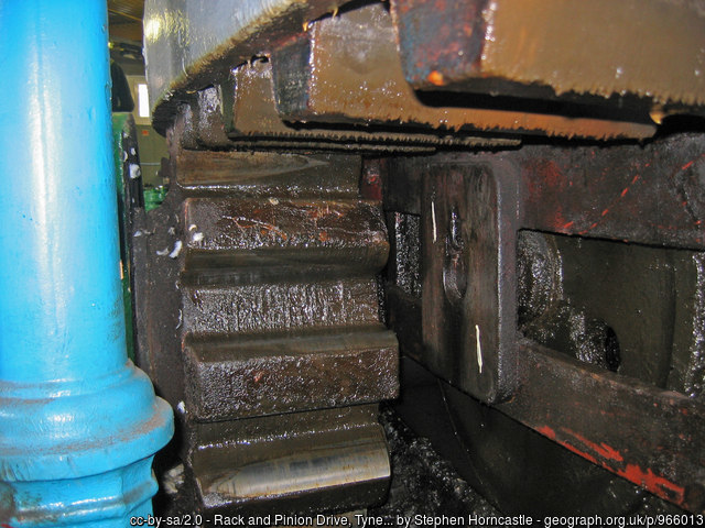
Above: A view of the rack and pinion system which drives the bridge.
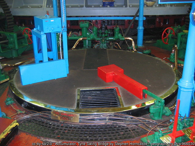
Above: View into the west side engine room and the top of the accumulator.
Above: This view inside the swing pier shows the original three-cylinder
oscillating hydraulic motors.
Above: William George Armstrong, 1st Baron Armstrong. Founder of W. G.
Armstrong and Company.
Official Heritage Listing Information and Findings
Listed At: Grade II*
Discussion:
List Entry Number: 1390930
Swing road and
pedestrian bridge, spanning the River Tyne. 1868-76, built on site of
the Roman and Medieval bridges. W.G. Armstrong & Co of Newcastle upon
Tyne for, and under supervision of, the Tyne Improvement Commission.
Steam pumps replaced by electric in 1959. Granite abutments and piers on
foundations of cast iron cylinders filled with concrete; timber control
cabin and central pontoon. Wrought iron girder superstructure. Six
spans, two over the land approach, two fixed spans over the water and
the two spans of the rotatable central portion. North and south land
abutments each of two piers arched together to provide an opening for
the passage of land traffic. Surmounted by four pillars extending above
the roadway topped with freestone and granite copings and groins. Coats
of Arms of Gateshead, Newcastle and Port of Tyne Authority carved in
relief on outsides of pillars. North and south piers with cutwaters and
a recess of arctuate shape at their top forming a ledge on which the end
of the bridge centre portion rests. Central pier with cutwaters supports
swinging section of bridge surrounded by a timber jetty extending to the
east and west to incorporate central pier of High Level Bridge. Two five
sided stone projections either end of central pier house machinery for
opening the bridge including original boilers, electric motors and
pumps, accumulators and hydraulic engines and gearing all in duplicate.
Bridge deck carries a roadway 7.3m wide with footways 2.4m wide either
side. Ornate lamp standards and closeable gates either end of fixed
sections. Maintenance platform suspended below deck on rollers. Swinging
section of bridge approximately 86m long revolves on a roller bearing
central pivot. Two large girders form two segmental arches filled with
latticework. Central arched linking bridge; octagonal timber cupola with
ogee roof and circular domed lantern on top. Swing span carries two iron
staircases to cupola. The bridge is operated by machinery activated by
high-pressure water from a hydraulic accumulator. Originally operated by
hydraulic motors, now electrically powered; the mechanism, housed on the
central pier is complete and operable. Swing bridge opened in 1876, a
necessary development to allow for up river navigation by sea going
vessels, particularly to Lord Armstrong's expanding Elswick Works. This
development gave considerable benefit to the rapidly developing industry
in that area. Hindmarsh R. F, 1930 Some of the Tyne Bridges, 6-9.
Manders F and Potts R 2001, Crossing the Tyne 48-56.
Original / Full Size Photos A collection of overview and detail photos. This gallery offers photos in the highest available resolution and file size in a touch-friendly popup viewer. Alternatively, Browse Without Using Viewer
Mobile Optimized Photos A collection of overview and detail photos. This gallery features data-friendly, fast-loading photos in a touch-friendly popup viewer. Alternatively, Browse Without Using Viewer