HistoricBridges.org Menu: HistoricBridges.org Menu:


We Recommend:
Bach Steel - Experts at historic truss bridge restoration.

HistoricBridges.org: Bridge Browser

Tintern Bridge

Old Tramway Bridge, Wireworks Bridge

Tintern Bridge

Primary Photographer(s): Nathan Holth

Bridge Documented: May 11, 2018

View Photos
and Videos
View Maps
and Links

Facility Carried / Feature Intersected
Private Walkway (Former Tramway) Over River Wye (Afon Gwy)
Location
Tintern (Tyndyrn): South West, England and Monmouthshire (Sir Fynwy), Wales (Cymru): United Kingdom
Structure Type
Metal Double-Intersection Warren Pony Truss, Fixed and Approach Spans: Stone Semicircular Deck Arch, Fixed
Construction Date and Builder / Engineer
1875 By Builder/Contractor: Reed Brothers of London, England and Isca Foundry of Newport, Wales and Engineer/Design: S. H. Yockney and Son of Westminster, England
Rehabilitation Date
Not Available or Not Applicable
Main Span Length
72.0 Feet (21.9 Meters)
Structure Length
265.0 Feet (80.8 Meters)
Roadway Width
Not Available
Spans
3 Main Span(s) and 2 Approach Span(s)
Inventory Number
Not Applicable

Historic Significance Rating (HSR)
View Information About HSR Ratings

Bridge Documentation

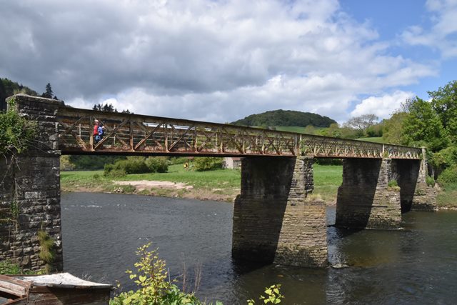
This former railway bridge retains its original materials and design despite conversion to a pedestrian bridge. Lengths given are very rough estimates.

As of 2022, this bridge is temporarily closed for repairs until Spring 2023

Official Heritage Listing Information and Findings

Listed At: Grade II

Discussion:

Reference Number: 24033

History
The bridge was constructed in 1872-5 and was actually ready for use before the railway which served it. It was designed by S H Yockney and Son of Westminster for the Wireworks branch of the Monmouth and Wye Valley Railway. The contractors were Reed Bros of London and the ironwork was supplied and erected by the Isca Foundry of Newport. The bridge was designed to carry no more than a small locomotive and three trucks. The Wireworks closed in 1901 but the bridge continued to carry a horse tramway until 1935 when it was finally closed and has been a footpath ever since.

Exterior
Constructed of sandstone ashlar with wrought iron. Three span single track railway bridge with two small side spans at the English end and a solid abutment at the Welsh end. Two semi-circular arches at the English end, three large sandstone piers, three spans of rivetted cross-braced wrought ironwork. The track ran through the girders which are separate over each span. The track bed has been boarded to act as a footpath. The bridge spans the border between Wales and England and between Monmouthshire and the Forest of Dean in Gloucestershire.

Interior

Reason for designation
Included as an unaltered wrought iron railway bridge of the 1860's, which has survived unchanged through very light use.

Divider

Photo Galleries and Videos: Tintern Bridge


View Photo Gallery

Bridge Photo-Documentation

Original / Full Size Photos
A collection of overview and detail photos. This gallery offers photos in the highest available resolution and file size in a touch-friendly popup viewer.
Alternatively, Browse Without Using Viewer

Divider

View Photo Gallery

Bridge Photo-Documentation

Mobile Optimized Photos
A collection of overview and detail photos. This gallery features data-friendly, fast-loading photos in a touch-friendly popup viewer.
Alternatively, Browse Without Using Viewer

Divider

Maps and Links: Tintern Bridge

Coordinates (Latitude, Longitude):

Search For Additional Bridge Listings:

HistoricBridges.org Bridge Browser: View listed bridges within 0.5 miles (0.8 kilometers) of this bridge.

HistoricBridges.org Bridge Browser: View listed bridges within 10 miles (16 kilometers) of this bridge.

Additional Maps:

Google Maps

Google Streetview (If Available)

Bing Maps

OpenStreetMap

GeoHack (Additional Links and Coordinates)

Apple Maps (Via DuckDuckGo Search)

Apple Maps (Apple devices only)

MapQuest

HERE We Go Maps

ACME Mapper

Waze Map

Android: Open Location In Your Map or GPS App

Flickr Gallery (Find Nearby Photos)

Wikimedia Commons (Find Nearby Photos)

Directions Via Sygic For Android

Directions Via Sygic For iOS and Android Dolphin Browser

Ordnance Survey Maps (UK Only)


Divider
 
Home Top

Divider

About - Contact

© Copyright 2003-2024, HistoricBridges.org. All Rights Reserved. Disclaimer: HistoricBridges.org is a volunteer group of private citizens. HistoricBridges.org is NOT a government agency, does not represent or work with any governmental agencies, nor is it in any way associated with any government agency or any non-profit organization. While we strive for accuracy in our factual content, HistoricBridges.org offers no guarantee of accuracy. Information is provided "as is" without warranty of any kind, either expressed or implied. Information could include technical inaccuracies or errors of omission. Opinions and commentary are the opinions of the respective HistoricBridges.org member who made them and do not necessarily represent the views of anyone else, including any outside photographers whose images may appear on the page in which the commentary appears. HistoricBridges.org does not bear any responsibility for any consequences resulting from the use of this or any other HistoricBridges.org information. Owners and users of bridges have the responsibility of correctly following all applicable laws, rules, and regulations, regardless of any HistoricBridges.org information.

Admin Login

Divider