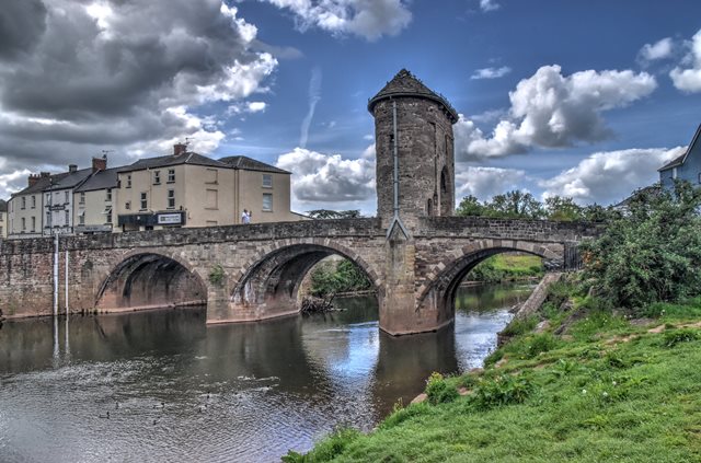
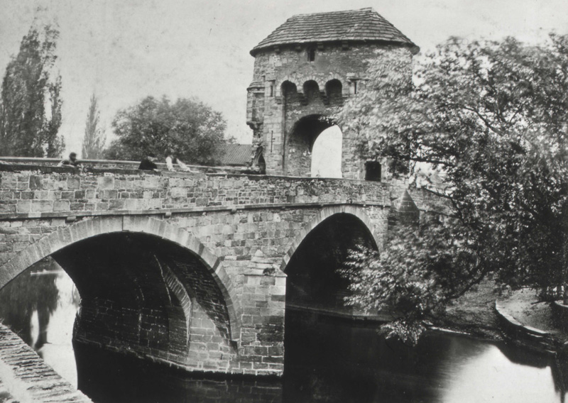
This unique medieval bridge with its tower on the deck is the only remaining fortified river bridge in Great Britain with an intact gate tower. As might be expected of a bridge this old, the exact date of construction is not known, but most sources cite 1272. The bridge has underwent a number of repairs and alterations over the course of its life. However, the essential design of the bridge consisting of the stone arches and the gatehouse tower remain intact on the bridge. This has led to the bridge's protection as a Grade I Listed Building as well as a Scheduled Monument. The below photo shows the bridge ca. 1866.
Official Heritage Listing Information and Findings
Listed At: Grade I (Also Scheduled Ancient
Monument)
Discussion:
History Medieval Bridge and Gateway, built in the
late C13 (traditionally 1272) to replace a timber bridge built by the
Normans (now known to date from the 1170s). This was a part of the
general improvement to the town's defences and walls undertaken
c1297-1315. The only surviving bridge gateway of its type in Britain,
although altered in the C18 and C19. The tower has been used at various
times as a toll-house, guard room, gaol and house-of-correction. The
gatehouse was last occupied by troops during the Chartist troubles in
1839. In 1705 it was converted into a two storey dwelling and the
battlemented parapet was removed and replaced by a roof arrangement
similar to the present one, but this was reconstructed in 1832. In 1819
the bridge was widened and the narrow north passageway pierced for
pedestrians involving considerable alteration to the structure, with the
loss of the original staircase. Originally the total width of the bridge
was comprised within the width of what is now the roadway, and footways
have been corbelled out on either side. The south footway was supposedly
made in 1845 but has a later concrete roof. Recently (2004) closed to
all traffic and a programme of works and repairs initiated.
Exterior Built of coursed red sandstone rubble with some patching in
buff sandstone, stone slate roof to gateway. Stone arched gate tower
built on the eastern pier of the three arched bridge. The bridge has
three pointed arches, with cutwaters on both sides of the piers, but the
arches are segmental where the outer faces were added in the C19. The
gate tower is elliptical in shape with two distinct elevations. The
west elevation has a tall recessed slightly pointed arch with foot
arches on either side, the north one with a pointed head and the south
one with a Caernarvon head and flat concrete ceiling. Above the main
arch there is an overhang with three arches on brackets under a wide
relieving arch. There are murder holes, while within the main arch there
are grooves for a portcullis. There are slit windows on either side of
the arch and another window above the centre of the relieving arch.
Projecting garderobe on the north-west side. The east face is plainer
and shows signs of more considerable rebuilding, with patching round the
arch. Round headed window above the centre of the arch. The inner
faces of the main arch have an oak access door on the south side and the
blocked original access on the north side which once gave entry to a
spiral stair. but this was lost when the north foot-arch was built.
The roof has projecting eaves on corbel brackets and is in the form of
two half cones joined by a central ridge.
Interior The
interior shows much more clearly how the stonework was repaired and
raised in the C19, including a number of courses of red brick at the
eaves. The roof structure has principal rafters with ties, all machine
cut, and numerous light secondary rafters and purlins. The garderobe
survives internally. There is no stair or surviving second floor.
Reasons for Listing Included and highly graded as an outstanding
medieval fortified bridge, now unique in Britain. Scheduled Ancient
Monument MM008(MON).
Photo Galleries and Videos: Monnow Bridge (Pont Trefynwy)
Original / Full Size Photos A collection of overview and detail photos. This gallery offers photos in the highest available resolution and file size in a touch-friendly popup viewer. Alternatively, Browse Without Using Viewer
Mobile Optimized Photos A collection of overview and detail photos. This gallery features data-friendly, fast-loading photos in a touch-friendly popup viewer. Alternatively, Browse Without Using Viewer