

View Information About HSR Ratings
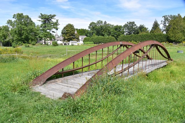
This is one of the only surviving patented Thomas Moseley iron arch bridges in existence, and it has been preserved on a privately owned public preserve called The Mile-Around Woods. The bridge is a bowstring truss/arch bridge. Typically bridges of this general overall design are called bowstring truss bridges, but often share a lot in common with arch bridges as well. However, this design lacks diagonal members and perhaps tips the scale more in favor of the arch category rather than the truss category. Even the patent for this bridge design is titled as a "truss bridge" but described in the details as being composed of "arches." Indeed, this only illustrates how unusual and highly significant this bridge is. It is among the oldest metal bridges in America and represents the period of experimentation in the development of iron bridges. The bridge as seen today has been moved and preserved here in 2013 after being in storage since 1958. The bridge originally crossed one arm of the Walloomsac River near the dam on Murphy Road (estimated coordinates: 42.912394, -73.235112). The bridge is narrower than it was when open for vehicular traffic. At the time this bridge was built, Thomas Moseley's company was named Moseley Iron Building Works.
![]()
![]()
![]()
Coordinates (Latitude, Longitude):
Search For Additional Bridge Listings:
Bridgehunter.com: View listed bridges within 0.5 miles (0.8 kilometers) of this bridge.
Bridgehunter.com: View listed bridges within 10 miles (16 kilometers) of this bridge.
Additional Maps:
Google Streetview (If Available)
GeoHack (Additional Links and Coordinates)
Apple Maps (Via DuckDuckGo Search)
Apple Maps (Apple devices only)
Android: Open Location In Your Map or GPS App
Flickr Gallery (Find Nearby Photos)
Wikimedia Commons (Find Nearby Photos)
Directions Via Sygic For Android
Directions Via Sygic For iOS and Android Dolphin Browser
USGS National Map (United States Only)
Historical USGS Topo Maps (United States Only)
Historic Aerials (United States Only)
CalTopo Maps (United States Only)

© Copyright 2003-2025, HistoricBridges.org. All Rights Reserved. Disclaimer: HistoricBridges.org is a volunteer group of private citizens. HistoricBridges.org is NOT a government agency, does not represent or work with any governmental agencies, nor is it in any way associated with any government agency or any non-profit organization. While we strive for accuracy in our factual content, HistoricBridges.org offers no guarantee of accuracy. Information is provided "as is" without warranty of any kind, either expressed or implied. Information could include technical inaccuracies or errors of omission. Opinions and commentary are the opinions of the respective HistoricBridges.org member who made them and do not necessarily represent the views of anyone else, including any outside photographers whose images may appear on the page in which the commentary appears. HistoricBridges.org does not bear any responsibility for any consequences resulting from the use of this or any other HistoricBridges.org information. Owners and users of bridges have the responsibility of correctly following all applicable laws, rules, and regulations, regardless of any HistoricBridges.org information.
![]()