



View Information About HSR Ratings
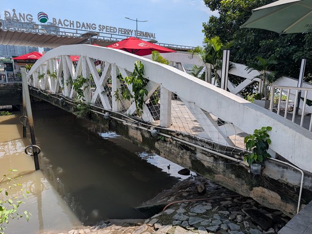
Bach Dang Wharf Pier No. 2 is a reinforced-concrete passenger ferry pier along the western bank of the Saigon River in central Ho Chi Minh City, formerly District 1. A pedestrian access bridge provides access to the pier from the adjacent waterfront. This structure forms part of the historic Bach Dang waterfront, an important center of commercial shipping, passenger transportation, and river activity dating back to the colonial period. This dock access bridge is an unusual design that is essentially a bowstring arch bridge with diagonal members, making it similar to a concrete truss as well. It appears to be original, and of French colonial era construction.
The Bach Dang waterfront has undergone numerous changes as the city has attempted to balance river transportation, commercial development, tourism, and the creation of public waterfront spaces. In 2015, the city ordered the relocation of hydrofoil passenger services and restaurant boats from the waterfront to accommodate redevelopment plans. However, significant portions of the redevelopment were delayed, and commercial passenger transportation eventually returned.
By 2018, GreenlinesDP was operating high-speed passenger ferries from Pier No. 2, connecting central Ho Chi Minh City with Can Gio and Vung Tau. The operator was also authorized to invest in improvements to the facility. Other passenger and restaurant vessels were subsequently permitted to use the pier. Government records identify GreenlinesDP as the operator of Pier No. 2 beginning in 2019.
The terminal became an important passenger transportation facility. During the first ten months of 2023, the pier accommodated approximately 85,000 passengers and more than 1,500 vessel movements. Government records describe the reinforced-concrete pier as approximately 80 meters long along the river and 9 meters wide. These dimensions refer to the pier facility rather than the individual pedestrian access bridge. The original construction date of the existing bridge and pier has not been determined.
The future of the facility became uncertain with plans for additional redevelopment of Bach Dang Park, particularly the construction of a new pedestrian bridge across the Saigon River connecting the waterfront with the Thu Thiem New Urban Area. In May 2025, GreenlinesDP temporarily suspended passenger ferry operations at Pier No. 2 in anticipation of construction activities. In July 2025, municipal authorities proposed demolishing the pier, reportedly because of deteriorated conditions and an alleged conflict with the new pedestrian bridge project. However, the new bridge is located a considerable distance north of this pier, and the reported physical conflict is not apparent from the completed bridge alignment.
On August 28, 2025, GreenlinesDP officially relocated its Saigon–Vung Tau passenger boarding operations from Pier No. 2 to nearby Pier No. 4, approximately 400 meters away near Ham Nghi Street.
Despite the proposed demolition and relocation of ferry operations, Pier No. 2 and its pedestrian access bridge remained standing as of October 16, 2026. Field documentation on that date confirmed that the pedestrian bridge was intact and accessible, while commercial activity continued at the terminal area, including a Highlands Coffee establishment and a visible ticket-office facility. The photograph does not establish whether passenger vessels continued to board at the original pier.
The future of the structure remains uncertain as the surrounding waterfront undergoes redevelopment. The original construction date and builder of the pier have not been determined, and no confirmed demolition date has been established.
Dimension given is an estimate.


Coordinates (Latitude, Longitude):
Search For Additional Bridge Listings:
Additional Maps:
Google Streetview (If Available)
GeoHack (Additional Links and Coordinates)
Apple Maps (Via DuckDuckGo Search)
Apple Maps (Apple devices only)
Android: Open Location In Your Map or GPS App
Flickr Gallery (Find Nearby Photos)
Wikimedia Commons (Find Nearby Photos)
Directions Via Sygic For Android
Directions Via Sygic For iOS and Android Dolphin Browser

© Copyright 2003-2026, HistoricBridges.org. All Rights Reserved. Disclaimer: HistoricBridges.org is a volunteer group of private citizens. HistoricBridges.org is NOT a government agency, does not represent or work with any governmental agencies, nor is it in any way associated with any government agency or any non-profit organization. While we strive for accuracy in our factual content, HistoricBridges.org offers no guarantee of accuracy. Information is provided "as is" without warranty of any kind, either expressed or implied. Information could include technical inaccuracies or errors of omission. Opinions and commentary are the opinions of the respective HistoricBridges.org member who made them and do not necessarily represent the views of anyone else, including any outside photographers whose images may appear on the page in which the commentary appears. HistoricBridges.org does not bear any responsibility for any consequences resulting from the use of this or any other HistoricBridges.org information. Owners and users of bridges have the responsibility of correctly following all applicable laws, rules, and regulations, regardless of any HistoricBridges.org information.
