


View Information About HSR Ratings
This bridge was made infamous on May 23, 2013 when an oversize truck crashed into the overhead bracing of this truss bridge, causing one of the spans to collapse. Although this has resulted in the bridge being used (wrongly) by the media and other organizations as evidence of "crumbling infrastructure" the bridge itself was in good condition and the remaining spans are in good condition. The bridge collapse was simple physics. An oversize truck crashed into the bracing, which in turn damaged the truss causing it to collapse.
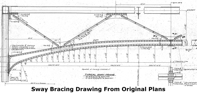
Following collapse and cleanup, a temporary Bailey truss was installed by June 19, 2013. By August 23, 2013, a new concrete beam span was built next to the Bailey truss on temporary piers and slid into place, providing a permanent replacement for the collapsed span. The sway bracing and portal bracing was also altered to remove the attractive arched design and make them flat to increase vertical clearance and prevent similar accidents in the future.
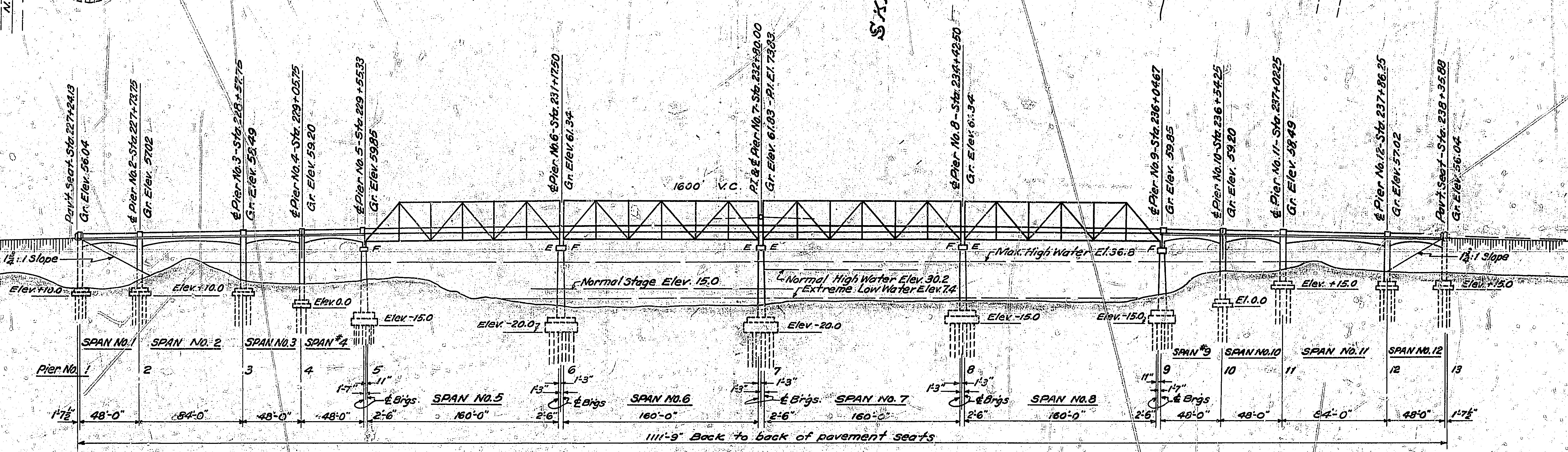
From a historic significance standpoint, this bridge is noted for its unusual design. With the exception of the end posts at the far ends of the truss span portion of the bridge, it features truss spans with vertical end posts, which make the bridge look like a continuous truss bridge, even though each span is a simple span. The extreme ends of the truss portion have inclined end posts, however this is only apparent at the south end today, due to the collapse of the northernmost truss span.
![]()
![]()
![]()

![]()
Coordinates (Latitude, Longitude):
Search For Additional Bridge Listings:
Bridgehunter.com: View listed bridges within 0.5 miles (0.8 kilometers) of this bridge.
Bridgehunter.com: View listed bridges within 10 miles (16 kilometers) of this bridge.
Additional Maps:
Google Streetview (If Available)
GeoHack (Additional Links and Coordinates)
Apple Maps (Via DuckDuckGo Search)
Apple Maps (Apple devices only)
Android: Open Location In Your Map or GPS App
Flickr Gallery (Find Nearby Photos)
Wikimedia Commons (Find Nearby Photos)
Directions Via Sygic For Android
Directions Via Sygic For iOS and Android Dolphin Browser
USGS National Map (United States Only)
Historical USGS Topo Maps (United States Only)
Historic Aerials (United States Only)
CalTopo Maps (United States Only)

© Copyright 2003-2026, HistoricBridges.org. All Rights Reserved. Disclaimer: HistoricBridges.org is a volunteer group of private citizens. HistoricBridges.org is NOT a government agency, does not represent or work with any governmental agencies, nor is it in any way associated with any government agency or any non-profit organization. While we strive for accuracy in our factual content, HistoricBridges.org offers no guarantee of accuracy. Information is provided "as is" without warranty of any kind, either expressed or implied. Information could include technical inaccuracies or errors of omission. Opinions and commentary are the opinions of the respective HistoricBridges.org member who made them and do not necessarily represent the views of anyone else, including any outside photographers whose images may appear on the page in which the commentary appears. HistoricBridges.org does not bear any responsibility for any consequences resulting from the use of this or any other HistoricBridges.org information. Owners and users of bridges have the responsibility of correctly following all applicable laws, rules, and regulations, regardless of any HistoricBridges.org information.
![]()