

View Information About HSR Ratings
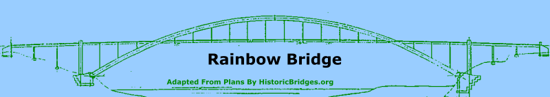
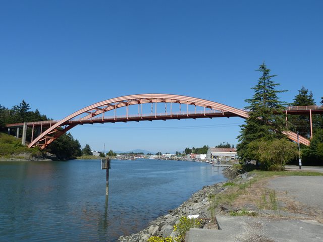
This bridge is an uncommon example of a riveted steel through arch bridge. Its apparent lack of hinges (first example in Washington), solid rib design, and lack of spandrel bracing give the bridge an uncommon and distinctive appearance. In 1958 the bridge received honorable mention during in the annual prize bridges literature produced by the American Institute of Steel Construction.
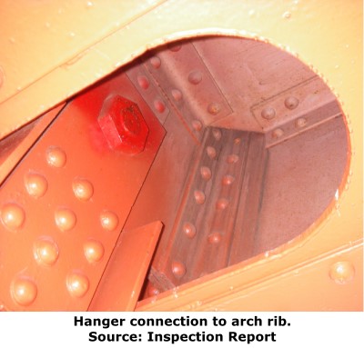
Without bridge inspection access and partly due to wire mesh covering the hole, the details of the hanger connection to the arch rib, which is concealed within the arch rib itself, are difficult for a visitor to observe. An inspection report for the bridge reveals that after passing through the bottom cover plate of the rib, a pin connects the hangers to the arch rib. The pin passes through the hanger and a pin plate which is riveted to the arch rib.
United Concrete Pipe Products Company in Auburn, Washington was listed as the fabricator of the bridge, while Neukirch Brothers of Seattle, Washington was the general contractor.
The bridge retains historic integrity with the only alteration of note being the alteration of the portal bracing to increase vertical clearance.
This bridge was found eligible for the National Register of Historic Places before it was 50 years old because of its pioneering design. Different, stronger types of steel were used in strategic places on the bridge to provide the best possible balance between strength and economy. To this day, the bridge is the longest span of its type in the state of Washington.
![]()
![]()
![]()
Coordinates (Latitude, Longitude):
Search For Additional Bridge Listings:
Bridgehunter.com: View listed bridges within 0.5 miles (0.8 kilometers) of this bridge.
Bridgehunter.com: View listed bridges within 10 miles (16 kilometers) of this bridge.
Additional Maps:
Google Streetview (If Available)
GeoHack (Additional Links and Coordinates)
Apple Maps (Via DuckDuckGo Search)
Apple Maps (Apple devices only)
Android: Open Location In Your Map or GPS App
Flickr Gallery (Find Nearby Photos)
Wikimedia Commons (Find Nearby Photos)
Directions Via Sygic For Android
Directions Via Sygic For iOS and Android Dolphin Browser
USGS National Map (United States Only)
Historical USGS Topo Maps (United States Only)
Historic Aerials (United States Only)
CalTopo Maps (United States Only)

© Copyright 2003-2026, HistoricBridges.org. All Rights Reserved. Disclaimer: HistoricBridges.org is a volunteer group of private citizens. HistoricBridges.org is NOT a government agency, does not represent or work with any governmental agencies, nor is it in any way associated with any government agency or any non-profit organization. While we strive for accuracy in our factual content, HistoricBridges.org offers no guarantee of accuracy. Information is provided "as is" without warranty of any kind, either expressed or implied. Information could include technical inaccuracies or errors of omission. Opinions and commentary are the opinions of the respective HistoricBridges.org member who made them and do not necessarily represent the views of anyone else, including any outside photographers whose images may appear on the page in which the commentary appears. HistoricBridges.org does not bear any responsibility for any consequences resulting from the use of this or any other HistoricBridges.org information. Owners and users of bridges have the responsibility of correctly following all applicable laws, rules, and regulations, regardless of any HistoricBridges.org information.
![]()