

View Information About HSR Ratings

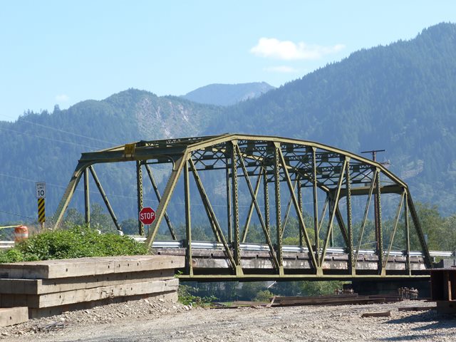
This bridge is an attractive example of a riveted Parker through truss. It was designed by the county. The approach spans are not original and are 1974 replacements for original timber spans. The metal truss main span however is original and is largely unaltered from its original design. The main alteration noted was the additional of beams to the floor beams, and loss of original railings.
Despite its historic significance, this historic bridge was targeted for replacement in 2014. The new bridge appears to be on new alignment next to the historic bridge. Therefore it would be feasible to do the responsible thing and leave this historic bridge standing for pedestrian use and for its historic value. The truss is in good condition, and would be able to serve pedestrians for decades. Sadly however, historic bridges are often demolished even if they are not in the way of their replacement.
This bridge replaced a wooden Howe truss bridge. It is shown below.

![]()
![]()
![]()
This historic bridge has been demolished. This map is shown for reference purposes only.
Coordinates (Latitude, Longitude):
Search For Additional Bridge Listings:
Bridgehunter.com: View listed bridges within 0.5 miles (0.8 kilometers) of this bridge.
Bridgehunter.com: View listed bridges within 10 miles (16 kilometers) of this bridge.
Additional Maps:
Google Streetview (If Available)
GeoHack (Additional Links and Coordinates)
Apple Maps (Via DuckDuckGo Search)
Apple Maps (Apple devices only)
Android: Open Location In Your Map or GPS App
Flickr Gallery (Find Nearby Photos)
Wikimedia Commons (Find Nearby Photos)
Directions Via Sygic For Android
Directions Via Sygic For iOS and Android Dolphin Browser
USGS National Map (United States Only)
Historical USGS Topo Maps (United States Only)
Historic Aerials (United States Only)
CalTopo Maps (United States Only)

© Copyright 2003-2026, HistoricBridges.org. All Rights Reserved. Disclaimer: HistoricBridges.org is a volunteer group of private citizens. HistoricBridges.org is NOT a government agency, does not represent or work with any governmental agencies, nor is it in any way associated with any government agency or any non-profit organization. While we strive for accuracy in our factual content, HistoricBridges.org offers no guarantee of accuracy. Information is provided "as is" without warranty of any kind, either expressed or implied. Information could include technical inaccuracies or errors of omission. Opinions and commentary are the opinions of the respective HistoricBridges.org member who made them and do not necessarily represent the views of anyone else, including any outside photographers whose images may appear on the page in which the commentary appears. HistoricBridges.org does not bear any responsibility for any consequences resulting from the use of this or any other HistoricBridges.org information. Owners and users of bridges have the responsibility of correctly following all applicable laws, rules, and regulations, regardless of any HistoricBridges.org information.
![]()