

View Information About HSR Ratings
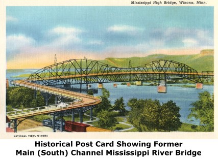
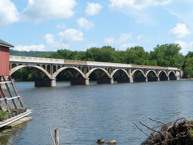
This long bridge is a beautiful structure with an interesting history. It has two components, each historically significant. The main spans are a series of open spandrel deck arch spans and date to 1916. These spans replaced a wooden trestle structure that provided an approach to the former crossing of the Main (South) Channel of the Mississippi River. A photo of the former south channel bridge called the High Bridge (and built in 1892) is shown to the right. In 1947, with the south channel bridge having been replaced, the north channel arch bridge was converted into a bridge that just led to the island. To do this, the southwestern end of the arch spans (which was elevated to meet the approach for the former main channel bridge) had a series of approach spans added to provide a ramp down to the island surface. These approach spans utilize a highly unusual design of cantilevered concrete girder spans. The spans are configured alternately. One span will have two arched girders that cantilever out from the piers and meet in the middle. A small gap in the middle of these spans is present indicating the cantilever function. In between these arched cantilever spans are anchor spans that are not cantilevered and instead serve to anchor and balance out the cantilever spans. These anchor spans are not arched and have straight girders. The overall bridge has the same railing design suggesting that the railings on the entire bridge date to 1947, not 1916. More recently, in 2004, this bridge was rehabilitated in part by private donations from a variety of individuals, to both preserve the bridge and provide access to a park.
![]()
![]()
![]()
Coordinates (Latitude, Longitude):
Search For Additional Bridge Listings:
Bridgehunter.com: View listed bridges within 0.5 miles (0.8 kilometers) of this bridge.
Bridgehunter.com: View listed bridges within 10 miles (16 kilometers) of this bridge.
Additional Maps:
Google Streetview (If Available)
GeoHack (Additional Links and Coordinates)
Apple Maps (Via DuckDuckGo Search)
Apple Maps (Apple devices only)
Android: Open Location In Your Map or GPS App
Flickr Gallery (Find Nearby Photos)
Wikimedia Commons (Find Nearby Photos)
Directions Via Sygic For Android
Directions Via Sygic For iOS and Android Dolphin Browser
USGS National Map (United States Only)
Historical USGS Topo Maps (United States Only)
Historic Aerials (United States Only)
CalTopo Maps (United States Only)

© Copyright 2003-2026, HistoricBridges.org. All Rights Reserved. Disclaimer: HistoricBridges.org is a volunteer group of private citizens. HistoricBridges.org is NOT a government agency, does not represent or work with any governmental agencies, nor is it in any way associated with any government agency or any non-profit organization. While we strive for accuracy in our factual content, HistoricBridges.org offers no guarantee of accuracy. Information is provided "as is" without warranty of any kind, either expressed or implied. Information could include technical inaccuracies or errors of omission. Opinions and commentary are the opinions of the respective HistoricBridges.org member who made them and do not necessarily represent the views of anyone else, including any outside photographers whose images may appear on the page in which the commentary appears. HistoricBridges.org does not bear any responsibility for any consequences resulting from the use of this or any other HistoricBridges.org information. Owners and users of bridges have the responsibility of correctly following all applicable laws, rules, and regulations, regardless of any HistoricBridges.org information.
![]()