

View Information About HSR Ratings
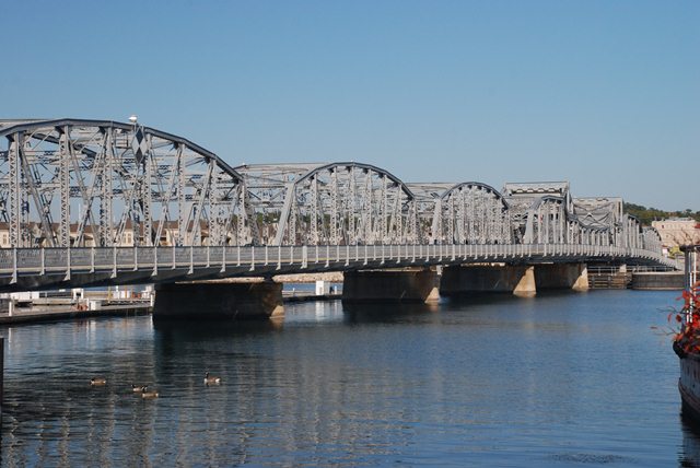
This bascule bridge consists of a through truss, double leaf Scherzer type rolling lift bascule bridge. Fixed through truss spans provide an approach to the bridge. These approach spans make this one of the most unique historic bascule bridges in existence. In the Great Lakes region, most movable bridges cross relatively small rivers, and as such only a short approach (if any) is present leading up to the movable span. Elsewhere in the country, such as on the east coast, movable bridges do have long fixed approaches that lead up to the movable span. However, even in these locations, the approach system is usually composed of small, mundane span types like steel stringer or t-beam spans. In contrast, the majority of the Sturgeon Bay Bridge's approach spans have a 165 foot span length which is actually slightly longer than the bascule span. As a result, the bridge is an impressive structure composed of beautiful trusses from start to finish. The bascule span itself is also significant as a rare truss bascule bridge in Wisconsin, and a significant example of a rolling lift type bascule in Wisconsin. The engineers who designed this bridge, Keller and Harrington, were previously associated with the Scherzer Rolling Lift Bridge Company, the inventors of the rolling lift bascule bridge type.
This is a large, landmark bridge that is highly significant. It also is located in a county with very few historic bridges. Despite this, the bridge was at risk for demolition until a group of citizens successfully managed to get demolition plans canceled for this bridge and instead have the bridge rehabilitated in 2010, the first major rehabilitation since 1979. The bridge is today one of the greatest historic bridge preservation success stories and an icon for the city. The Steel Bridge Songfest, originally held to raise funds to help save the bridge continues to take place in the wake of the rehabilitation.

Above: Aerial view of bridge, August 14, 2020. Click for enlargement. Photo Credit: Doug Heim, Angelcopter, LLC
|
Main Plaque STUREGON BAYBRIDGE 1930 DESIGNED BY WISCONSIN HIGHWAY COMMISSION BUILT BY WAUSAU IRON WORKS WAUSAU WISCONSIN |
Lift Span Plaque LIFT SPAN |
Memorial Plaque DEDICATED TO HONOR |
National Register Plaque STURGEON BAY |
![]()
![]()
![]()

![]()
![]()
Coordinates (Latitude, Longitude):
Search For Additional Bridge Listings:
Bridgehunter.com: View listed bridges within 0.5 miles (0.8 kilometers) of this bridge.
Bridgehunter.com: View listed bridges within 10 miles (16 kilometers) of this bridge.
Additional Maps:
Google Streetview (If Available)
GeoHack (Additional Links and Coordinates)
Apple Maps (Via DuckDuckGo Search)
Apple Maps (Apple devices only)
Android: Open Location In Your Map or GPS App
Flickr Gallery (Find Nearby Photos)
Wikimedia Commons (Find Nearby Photos)
Directions Via Sygic For Android
Directions Via Sygic For iOS and Android Dolphin Browser
USGS National Map (United States Only)
Historical USGS Topo Maps (United States Only)
Historic Aerials (United States Only)
CalTopo Maps (United States Only)

© Copyright 2003-2026, HistoricBridges.org. All Rights Reserved. Disclaimer: HistoricBridges.org is a volunteer group of private citizens. HistoricBridges.org is NOT a government agency, does not represent or work with any governmental agencies, nor is it in any way associated with any government agency or any non-profit organization. While we strive for accuracy in our factual content, HistoricBridges.org offers no guarantee of accuracy. Information is provided "as is" without warranty of any kind, either expressed or implied. Information could include technical inaccuracies or errors of omission. Opinions and commentary are the opinions of the respective HistoricBridges.org member who made them and do not necessarily represent the views of anyone else, including any outside photographers whose images may appear on the page in which the commentary appears. HistoricBridges.org does not bear any responsibility for any consequences resulting from the use of this or any other HistoricBridges.org information. Owners and users of bridges have the responsibility of correctly following all applicable laws, rules, and regulations, regardless of any HistoricBridges.org information.
![]()