We Recommend:
Bach Steel - Experts at historic truss bridge restoration.
BridgeHunter.com Phase 1 is released to the public! - Visit Now
Tiffany Bridge
Smith Road Bridge

Primary Photographer(s): Mark Boettcher
Bridge Documented: October 7, 2020
Rural: Rock County, Wisconsin: United States
1910 By Builder/Contractor: Worden-Allen Company of Milwaukee, Wisconsin
Not Available or Not Applicable
120.0 Feet (36.6 Meters)
122.0 Feet (37.2 Meters)
14.8 Feet (4.51 Meters)
1 Main Span(s)
P53015300000000

View Information About HSR Ratings
Bridge Documentation
View This Relocated Historic Bridge's Page In Its Previous Smith Road Location Here
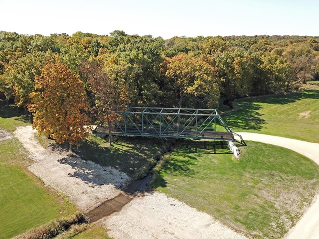
This bridge was moved to private property. The owner, the Luety family, says though the bridge will be on their property, they want to allow the community to continue to use it for photos – with permission. They also have plans to include it as a portion of a nearby snowmobiling trail.
This 1910 bridge is an extremely unusual and early example of the truss bridge using bolted connections for all connection points. Its design is very similar to an average truss bridge from the period with riveted connection, except that there are bolts holding the members to the gusset plates.
During the late 1800s, pinned connections were the most common form of connection used on truss bridges because field riveting equipment and skilled labor was not available to erect the bridges on-site using riveted connections. Bolts were used sparingly, generally only to assemble segmented pieces of the larger shop riveted beams together, such as the top chord. As the 20th Century rolled around and field riveting became available, then riveted connections became common, and rivets were used for mostly everything until the 1960s. As such, bolted connections did not become overly popular until the 1970s.
This bridge is otherwise traditionally composed for a 1910 bridge, with built-up beams composing the truss web and an a-frame portal bracing. The bridge has been altered with the addition of welded plates to portions of the truss. In addition, some of the original bolts (having square-shaped nuts) have been replaced with modern high-strength bolts (having hexagonal bolts). These alterations have diminished the historic integrity of the bridge, however because of this bridge's bolted connections, the bridge remains significant.
This bridge is tagged with the following special condition(s): Unorganized Photos
![]()
Photo Galleries and Videos: Tiffany Bridge
Unorganized Photos
Original / Full Size PhotosA collection of overview and detail photos, presented as an unorganized and unlabeled collage and gallery. This gallery offers photos in the highest available resolution and file size in a touch-friendly popup viewer.
Alternatively, Browse Without Using Viewer
![]()
Unorganized Photos
Mobile Optimized PhotosA collection of overview and detail photos, presented as an unorganized and unlabeled collage and gallery. This gallery features data-friendly, fast-loading photos in a touch-friendly popup viewer.
Alternatively, Browse Without Using Viewer
![]()
Maps and Links: Tiffany Bridge
This bridge is on private property.
Coordinates (Latitude, Longitude):
Search For Additional Bridge Listings:
Bridgehunter.com: View listed bridges within 0.5 miles (0.8 kilometers) of this bridge.
Bridgehunter.com: View listed bridges within 10 miles (16 kilometers) of this bridge.
Additional Maps:
Google Streetview (If Available)
GeoHack (Additional Links and Coordinates)
Apple Maps (Via DuckDuckGo Search)
Apple Maps (Apple devices only)
Android: Open Location In Your Map or GPS App
Flickr Gallery (Find Nearby Photos)
Wikimedia Commons (Find Nearby Photos)
Directions Via Sygic For Android
Directions Via Sygic For iOS and Android Dolphin Browser
USGS National Map (United States Only)
Historical USGS Topo Maps (United States Only)
Historic Aerials (United States Only)
CalTopo Maps (United States Only)

