


View Information About HSR Ratings

In addition to information specifically about Bridge #1 on McGilvray Road, this special webpage also provides both an overview of McGilvray Road in general and a general discussion of all six bridges remaining on McGilvray Road, followed by the discussion of McGilvray Road Bridge #1 specifically. Specific discussions for the other five bridges are located each on their own respective webpages. The below map shows McGilvray Road as it exists today. You can click on the name of a bridge to switch to that bridge's page.


McGilvray Road is a road whose name and history can be traced back to Alexander McGilvray who settled in the area in 1852 and later established a ferry that crossed Black River in the area. By 1892 a bridge was built over the Black River including several pile bridges east of the main channel bridge to carry the road over the swampy bottoms east of the river. These bridges east of the river were soon damaged and/or washed away in a flood. By 1903 an investigation was underway to consider building more permanent bridges east of the main channel bridge. As a result, from 1905-1907 at least five new bridges were built in the bottoms area. These bridges were built by the La Crosse Bridge and Steel Company using an extremely unusual patented bowstring truss design. There was a sixth crossing in the bottoms area (Bridge #5), but it is not known if this crossing was rebuilt at this time. A few years after these bridges were built another flood occurred and damaged the road. This ongoing problem and costs associated with these floods made the road and its maintenance somewhat controversial. By 1919 there was consideration of abandoning the road, although many people used the road and as a result opposition to abandonment was strong. This idea was dismissed as a result, just in time for another damaging flood in 1920. It is around this time that the "black sheep" on the road, Bridge #5, was apparently rebuilt as a wooden Kingpost truss. The Wisconsin State Highway Department decided to realign its State Trunk Highway 162 in the area to make use of McGilvray Road, and so in 1927 the road became a state highway. This did not last long however, since in 1933 the state realigned the highway back to its location prior to using McGilvray Road, but continued to own McGilvray Road as a detour route until 1940 at which point the road was apparently returned to local control by La Crosse County. At this time the road was in poor condition and it appears the road was closed during the 1940s. The decision by the state highway commission to build a new highway and bridge 1.5 miles south of McGilvray Road essentially made McGilvray Road redundant when it was opened in 1953. At this point the road was effectively abandoned as a through route, a change solidified when the bridge over the main channel of the Black River was demolished. The bridges over the swampy bottoms east of the main channel remained in place however, owned and operated by the town of Holland to provide access to the DNR owned Van Loon Wildlife Area. Yet another flood damaged the road and bridges in 1970, and because Holland was unable to afford to repair the damage, the road and bridges were given to the DNR. By the 1980s, the bowstring truss bridges were listed on the National Register of Historic Places, but the DNR closed them to all traffic including pedestrians in 1985. In 1986, Bridge #5, the wooden Kingpost, was demolished. In 1989, the Friends of McGilvray Road was formed to work with the DNR to find a way to preserve and maintain the road and bridges as a trail. The effort was successful with the official reopening of the bridges to non-motorized traffic in 1997. Bridge #5 was reopened by relocating and preserving a historic pony truss from Pierce County, Wisconsin.
Today, the McGilvray Road is a trail for pedestrians through the Van Loon Wildlife Area. The trail is noteworthy both for its historically significant bridges, but also as an outstanding preservation success story. The Friends of McGilvray Road continue to maintain the trail and bridges, which is no small task, since the road continues to be seasonally assaulted by floods, something the road has faced practically from the day it was built. Visitors to this unique destination should consider the water levels. During times of high water levels, you might only be able to get down the trail part of the way, since some sections of the road can be overtaken by flood waters during these times. HistoricBridges.org visited this location twice, once during a high water event in June and again in August with normal water levels. During the June visit, only three bridges could be reached, and boots were needed to access the third bridge. Photos from that visit are included in the photos for those three bridges so you can see what it looked like. Bug spray is also advised for times of the year when things like mosquitos and deer flies are active. Parking for the trail is available at the eastern end of the trail, just off of Amsterdam Prairie Road.
Preservation of these bridges is not without cost or effort, and the Friends of McGilvray Road can always use help both in the form of donations and volunteers. If you appreciate the efforts to preserve these historic bridges consider donating. They have a couple different membership options available as well. Please visit their website for more information on how you can help.
 All six of the bridges found on McGilvray are historic.
The relocated Bridge #5 is an outstanding example of how historic truss bridges make great candidates for relocation and reuse for non-motorized traffic. The bridge is an example of a bridge type that was once extremely common, but is today
rare, especially in Wisconsin where so many truss bridges have been demolished that truss bridges of any type are uncommon today in the state.
All six of the bridges found on McGilvray are historic.
The relocated Bridge #5 is an outstanding example of how historic truss bridges make great candidates for relocation and reuse for non-motorized traffic. The bridge is an example of a bridge type that was once extremely common, but is today
rare, especially in Wisconsin where so many truss bridges have been demolished that truss bridges of any type are uncommon today in the state.
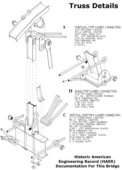
The remaining five bowstring truss bridges can not be so quickly discussed. These five bowstring truss bridges are some of the most unique and unusual bridges in existence. They are built to a design developed and patented by Charles M. Horton in 1897. His bizarre bridge design was the outcome of his unusual opinions about bridges. Horton felt that the holes that accommodated rivets weakened the metal of bridges and that stronger, longer-lasting bridges would be those bridges which avoided the use of such holes. He came up with a design that used other methods to hold the bridge parts together. Since the built-up beams that were commonly used for bridge beams in 1897 were assembled with rivets, it is unsurprising that Horton's design instead used a rolled beam for the top chord. The rolled beam was bent at certain points to produce an overall curved shape, which likely to Horton's delight, avoided the need to rivet or bolt together multiple shorter straight beams to form the curve-like polygonal shape, which was common in bridge design at the time. To allow the other truss members to make pin connections to the curved top chord of the bowstring, while avoiding the use of rivets and traditional gusset or pin plates, Horton employed the most unusual construction detail of his bridge design: special hook clips that clip onto and grip the top chord, and have holes at the bottom to hold the pin for the connection. These hook clips are not the same size throughout each truss, so each clip has an identification number cast into it to identify its size. In contrast, the connections at the bottom chord are more traditional, including a pin plate riveted to the vertical members. The floor beams are traditionally hung from the connection with u-bolts. The second most unusual detail of these bridges is the truss configuration. Traditional bowstring truss bridges (mostly built in the 1870s) have diagonal members that extend from each panel point to form an "x" shape in each panel. The Horton design includes this, but also adds two additional diagonals (one diagonal at the end panels) extending from the top chord in the center of each panel. These additional diagonals form an truss with an intersecting design to them. The other unusual detail of the truss configuration is that the verticals are not strictly vertical, and run somewhat diagonally from the top chord. These unusual truss configuration details give the bridges an unusual, distinctive appearance.
 In addition to their unusual design, the
actual idea that someone would design a bridge in 1897 with a patented design that was composed of so many unusual, non-standard details is itself unusual. Moreover, building a bowstring truss in 1897 was unusual. By 1897, truss design had
generally abandoned both the use of bowstring truss designs, as well as unusual, non-standard design details. The move was toward more traditional truss designs such as the trapezoidal shaped trusses with Pratt and Warren configurations or
even versions of those trusses with polygonal top chords such as the Parker truss. The move starting in the 1880s was also to abandon unusual, non-standard details in favor of simpler and more standardized details both in terms of beam
design and the ways in which the truss beams were connected. For this reason, the design Charles Horton came up with looks in many ways like something designed in the 1870s, where both bowstring truss bridges and non-standard patented
design details were common. At the same time, some aspects of the Horton design are modern in appearance, most specifically composing the top chord from a simple rolled beam rather than a riveted built-up beam which was in many ways ahead
of its time. Avoiding the use of built-up beams, particularly for heavier parts of a truss like the top chord, did not become common until the middle of the 20th Century. Amidst all these behind-the-times and ahead-of-the-times details was
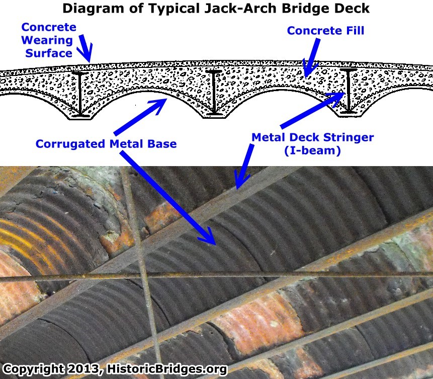
the fact that at least some of these bridges were built with a concrete jack-arch deck. Concrete jack-arch bridge decks enjoyed a brief popularity during the first two decades of the 20th Century, and so their use on these bridges built
between 1905-1908 is not unusual. Concrete jack-arch decks are extremely rare among surviving bridges today, and most that survive are deteriorated. It is perhaps not surprising that the jack-arch decks on these bowstring bridges have been
replaced. The bridges today all have wooden decks.
In addition to their unusual design, the
actual idea that someone would design a bridge in 1897 with a patented design that was composed of so many unusual, non-standard details is itself unusual. Moreover, building a bowstring truss in 1897 was unusual. By 1897, truss design had
generally abandoned both the use of bowstring truss designs, as well as unusual, non-standard design details. The move was toward more traditional truss designs such as the trapezoidal shaped trusses with Pratt and Warren configurations or
even versions of those trusses with polygonal top chords such as the Parker truss. The move starting in the 1880s was also to abandon unusual, non-standard details in favor of simpler and more standardized details both in terms of beam
design and the ways in which the truss beams were connected. For this reason, the design Charles Horton came up with looks in many ways like something designed in the 1870s, where both bowstring truss bridges and non-standard patented
design details were common. At the same time, some aspects of the Horton design are modern in appearance, most specifically composing the top chord from a simple rolled beam rather than a riveted built-up beam which was in many ways ahead
of its time. Avoiding the use of built-up beams, particularly for heavier parts of a truss like the top chord, did not become common until the middle of the 20th Century. Amidst all these behind-the-times and ahead-of-the-times details was
the fact that at least some of these bridges were built with a concrete jack-arch deck. Concrete jack-arch bridge decks enjoyed a brief popularity during the first two decades of the 20th Century, and so their use on these bridges built
between 1905-1908 is not unusual. Concrete jack-arch decks are extremely rare among surviving bridges today, and most that survive are deteriorated. It is perhaps not surprising that the jack-arch decks on these bowstring bridges have been
replaced. The bridges today all have wooden decks.
In 1900, armed with his patented bridge design, Charles M. Horton created a bridge company called Horton Bridge and Steel Company. However, a year after he formed the company, he left the company, with the arrangement that the company could build his patented bridges, but Horton would receive royalty payments from the company. At this time, the company was renamed LaCrosse Bridge and Steel Company and William Torrance became the company president and manager. As such, it was the LaCrosse Bridge and Steel Company that built the bridges for McGilvray Road. Charles Horton designed the patented truss design, but he would not have been directly involved with the design or construction of the bridges at McGilvray Road since he had left the company.
Outside of McGilvray Road, only one other example of this patented bowstring truss is known to remain, and it is in Amnicon Falls State Park. That bridge has had the most unfortunate fate of being covered by a pointless wooden covering (to casual viewers it would look like a covered bridge) and so the McGilvray Road is the only place where these unique truss bridges can be viewed without obstruction or noteworthy alteration. All of the McGilvray Road Bridges retain good overall historic integrity with no major alterations or visual obstructions, aside from the loss of the concrete jack-arch decks on some of the bridges.
Bridge #1 is located only a short distance west of the parking area. It is one of the three two-span bridges on the road. The bridge rests on steel caissons (sometimes called Lally columns). This bridge retains excellent historic integrity with no noteworthy alterations to the trusses observed. The top chord has Jones and Laughlins rolled into the beams indicating the source of the steel. Among the bowstring bridges on this road, this is perhaps the most "average" bridge, since it is neither the oldest, newest, longest or shortest. In 1987, prior to restoration, this bridge had a wooden deck. Some of the bowstring bridges originally had a concrete jack-arch deck, and it is not known if this bridge might have originally had such a deck as well.
![]()
![]()
![]()
Coordinates (Latitude, Longitude):
Search For Additional Bridge Listings:
Bridgehunter.com: View listed bridges within 0.5 miles (0.8 kilometers) of this bridge.
Bridgehunter.com: View listed bridges within 10 miles (16 kilometers) of this bridge.
Additional Maps:
Google Streetview (If Available)
GeoHack (Additional Links and Coordinates)
Apple Maps (Via DuckDuckGo Search)
Apple Maps (Apple devices only)
Android: Open Location In Your Map or GPS App
Flickr Gallery (Find Nearby Photos)
Wikimedia Commons (Find Nearby Photos)
Directions Via Sygic For Android
Directions Via Sygic For iOS and Android Dolphin Browser
USGS National Map (United States Only)
Historical USGS Topo Maps (United States Only)
Historic Aerials (United States Only)
CalTopo Maps (United States Only)

© Copyright 2003-2025, HistoricBridges.org. All Rights Reserved. Disclaimer: HistoricBridges.org is a volunteer group of private citizens. HistoricBridges.org is NOT a government agency, does not represent or work with any governmental agencies, nor is it in any way associated with any government agency or any non-profit organization. While we strive for accuracy in our factual content, HistoricBridges.org offers no guarantee of accuracy. Information is provided "as is" without warranty of any kind, either expressed or implied. Information could include technical inaccuracies or errors of omission. Opinions and commentary are the opinions of the respective HistoricBridges.org member who made them and do not necessarily represent the views of anyone else, including any outside photographers whose images may appear on the page in which the commentary appears. HistoricBridges.org does not bear any responsibility for any consequences resulting from the use of this or any other HistoricBridges.org information. Owners and users of bridges have the responsibility of correctly following all applicable laws, rules, and regulations, regardless of any HistoricBridges.org information.
![]()