

View Information About HSR Ratings
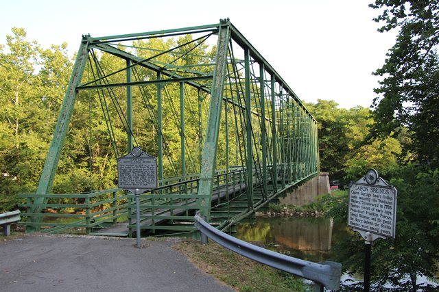
The South Branch Bridge is an extremely old and rare example of a pin-connected Whipple (Double-Intersection Pratt) through truss that also has several unusual and distinctive construction details. The bridge’s trusses are listed as being originally built in 1874 near Romney, West Virginia on what is today US-50. It was moved to this location in 1938. The potential relocation of this bridge, particularly so many decades ago, does not disqualify the bridge for listing in the National Register of Historic Places. Pin-connected truss bridges were noted for the ease in which they could be disassembled and relocated, a unique trait not shared by most other bridge types. It was common many decades ago, when they became insufficient for their original location, to relocate and reuse pin-connected truss bridges at other locations where the bridge could still be useful. This is part of their history.
Nationwide, only a very small number of metal truss bridges date to before 1880. The South Branch Bridge’s 1874 construction date thus places it among the oldest surviving metal truss bridges in the county. In addition, bridges built before 1880 were built in a period of experimentation and development of the metal truss bridge in the United States that tapered off by the early 1880s as builders gravitated toward more reliable standardized designs. During this period of experimentation, different builders experimented with a variety of creative and unusual designs, form the overall truss design down to specific construction details. The South Branch Bridge displays some of these unusual construction details. The composition of the built-up top chord and end post follows an unusual design. The use of “threaded rod with nut” connections on the top chord are also non-standard truss details. At the same time, the bridge displays some of the details that would continue to be seen in the more standardized trusses of the 1880s. These details include the use of traditional pin connections on the bottom chord, as well as the overall Whipple truss configuration.
As a result, the South Branch Bridge is historically and technologically significant because it documents the period of transition from experimentation to standardization of metal truss bridge construction in the United States. In addition, the bridge’s Whipple truss configuration, generally reserved for spans in excess of 140 feet, (the Single Intersection Pratt truss was usually used for shorter spans) is today a rare truss configuration both nationwide and in West Virginia.
Today, this bridge has been bypassed and preserved in an unusual fashion. Although a walkway is maintained on the bridge, it ends at the south end of the span because the approach spans no longer remain at that end of the bridge.
![]()
![]()
![]()
Coordinates (Latitude, Longitude):
Search For Additional Bridge Listings:
Bridgehunter.com: View listed bridges within 0.5 miles (0.8 kilometers) of this bridge.
Bridgehunter.com: View listed bridges within 10 miles (16 kilometers) of this bridge.
Additional Maps:
Google Streetview (If Available)
GeoHack (Additional Links and Coordinates)
Apple Maps (Via DuckDuckGo Search)
Apple Maps (Apple devices only)
Android: Open Location In Your Map or GPS App
Flickr Gallery (Find Nearby Photos)
Wikimedia Commons (Find Nearby Photos)
Directions Via Sygic For Android
Directions Via Sygic For iOS and Android Dolphin Browser
USGS National Map (United States Only)
Historical USGS Topo Maps (United States Only)
Historic Aerials (United States Only)
CalTopo Maps (United States Only)

© Copyright 2003-2026, HistoricBridges.org. All Rights Reserved. Disclaimer: HistoricBridges.org is a volunteer group of private citizens. HistoricBridges.org is NOT a government agency, does not represent or work with any governmental agencies, nor is it in any way associated with any government agency or any non-profit organization. While we strive for accuracy in our factual content, HistoricBridges.org offers no guarantee of accuracy. Information is provided "as is" without warranty of any kind, either expressed or implied. Information could include technical inaccuracies or errors of omission. Opinions and commentary are the opinions of the respective HistoricBridges.org member who made them and do not necessarily represent the views of anyone else, including any outside photographers whose images may appear on the page in which the commentary appears. HistoricBridges.org does not bear any responsibility for any consequences resulting from the use of this or any other HistoricBridges.org information. Owners and users of bridges have the responsibility of correctly following all applicable laws, rules, and regulations, regardless of any HistoricBridges.org information.
![]()