

View Information About HSR Ratings
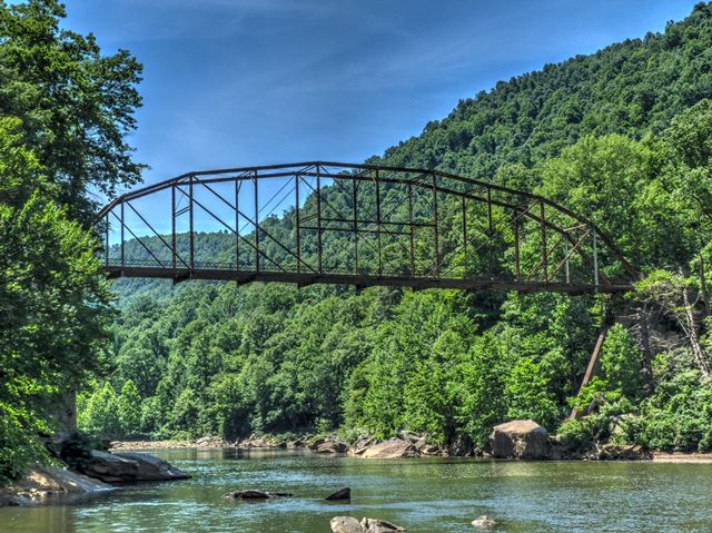
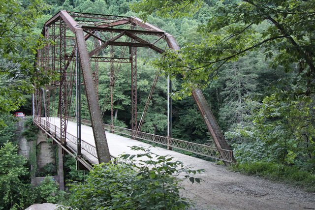
This spectacular bridge soars over the river it crosses at substantial elevation. This makes what is already an impressive pin-connected Pennsylvania through truss bridge even more impressive. The pristine mountainous setting only adds to the setting. While the bridge does have some alterations and repairs, the overall historic integrity of the bridge is good. It is today, thanks to demolition, an increasingly rare and significant example of what was already an uncommon bridge type.
Although straight line distance, this bridge is only around 11 miles from downtown Morgantown, this bridge's location can only be described as extremely remote and rural. The road to this bridge is completely unimproved. Anyone without familiarity with this road and area (and West Virginia in general) is recommended to utilize a vehicle with decent ground clearance and only attempt to access the bridge when the road is dry. The road is composed of large boulders and a car driving the road must be driven at the speed of a slow walk, and the sensation to the driver will be that of being in a boat on rough waters. Driving to this bridge you may feel that you are going where nobody has been for years and if you get stuck your corpse will not be discovered for years. However, the bridge and surrounding area appears to be a highly popular local destination and you may be surprised to find many cars and people there at times. The private property owners have opened their land to the respectful use of the public, so the area is essentially a park. It was interesting to note that despite the road being what people who don't live in West Virginia would describe as a very intimidating, unimproved road to drive, there were compact cars that had successfully made the drive back to this bridge. To add to the adventure, when the bridge was field visited in 2014, the approaching roadway right at the bridge deck was somewhat washed away, and someone had piled up some rocks to help people get up the short, but sharp bump up onto the bridge deck. If your speed was not just right you either wouldn't make the jump and would spin your tires, or you would have a very rough and violent bump up onto the bridge.
Given this bridge's rural location, its interesting to imagine over 100 years ago this bridge being erected at this location. To do so was undoubtedly a challenge, yet this road must have at one time been important enough to justify the effort.
This bridge is tagged with the following special condition(s): Unorganized Photos
![]()
![]()
![]()
![]()
![]()
The road leading to this bridge is completely unimproved, composed of large boulders, and must be driven with great care.
Coordinates (Latitude, Longitude):
Search For Additional Bridge Listings:
Bridgehunter.com: View listed bridges within 0.5 miles (0.8 kilometers) of this bridge.
Bridgehunter.com: View listed bridges within 10 miles (16 kilometers) of this bridge.
Additional Maps:
Google Streetview (If Available)
GeoHack (Additional Links and Coordinates)
Apple Maps (Via DuckDuckGo Search)
Apple Maps (Apple devices only)
Android: Open Location In Your Map or GPS App
Flickr Gallery (Find Nearby Photos)
Wikimedia Commons (Find Nearby Photos)
Directions Via Sygic For Android
Directions Via Sygic For iOS and Android Dolphin Browser
USGS National Map (United States Only)
Historical USGS Topo Maps (United States Only)
Historic Aerials (United States Only)
CalTopo Maps (United States Only)

© Copyright 2003-2026, HistoricBridges.org. All Rights Reserved. Disclaimer: HistoricBridges.org is a volunteer group of private citizens. HistoricBridges.org is NOT a government agency, does not represent or work with any governmental agencies, nor is it in any way associated with any government agency or any non-profit organization. While we strive for accuracy in our factual content, HistoricBridges.org offers no guarantee of accuracy. Information is provided "as is" without warranty of any kind, either expressed or implied. Information could include technical inaccuracies or errors of omission. Opinions and commentary are the opinions of the respective HistoricBridges.org member who made them and do not necessarily represent the views of anyone else, including any outside photographers whose images may appear on the page in which the commentary appears. HistoricBridges.org does not bear any responsibility for any consequences resulting from the use of this or any other HistoricBridges.org information. Owners and users of bridges have the responsibility of correctly following all applicable laws, rules, and regulations, regardless of any HistoricBridges.org information.
![]()