

View Information About HSR Ratings
2024 Update:
Satolli Glassmeyer visited this bridge in 2024 and produced the following video, showing how overgrown the bridge has become since HistoricBridges.org documented the bridge in 2007!
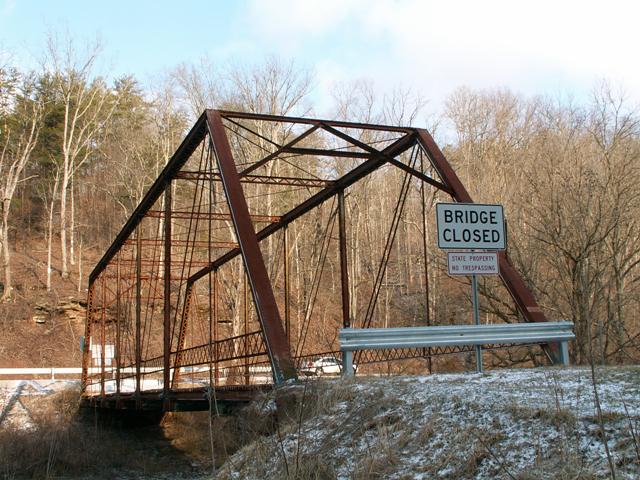
This bridge is composed of seven panels. It is a traditionally composed structure, although it features an unusual x-shaped decorative elements along the top of the portal bracing. This detail was found on bridges built by the Canton Bridge Company of Canton, Ohio, however usually these bridges did not have v-lacing on their struts as found on this bridge so the association is not completely certain.
Interestingly, this bridge was bypassed with a modern truss bridge, but the historic truss bridge was not demolished and was instead allowed to continue standing. Many states, particularly PennDOT refuse to do this, and complain about worries of liability, even though there is no documentation of lawsuits over historic bridges. The Shanley Road Bridge is a great example. West Virginia however, implemented the solution to liability that this website has voiced for years. To mitigate any liability, the state posted no trespassing signs in front of the bridge. Thus, this signage essentially protects West Virgnia, because if someone gets injured on the bridge, they were breaking the law anyway. While not a preservation project, this is still a favorable outcome. Often, when a bridge is built on a new alignment, the historic bridge is demolished, even if it is not in the way of its replacement, representing a significant waste of taxpayer money and needless loss of a historic structure. Even without repair, the CR-3 bridge will likely stand as is for decades to come. However, because it is not demolished and is still standing, it also leaves open the possibility for preservation in the future when it is expected that public awareness for truss bridges will increase due to the fact that they are quickly becoming very rare.
![]()
![]()
Coordinates (Latitude, Longitude):
Search For Additional Bridge Listings:
Bridgehunter.com: View listed bridges within 0.5 miles (0.8 kilometers) of this bridge.
Bridgehunter.com: View listed bridges within 10 miles (16 kilometers) of this bridge.
Additional Maps:
Google Streetview (If Available)
GeoHack (Additional Links and Coordinates)
Apple Maps (Via DuckDuckGo Search)
Apple Maps (Apple devices only)
Android: Open Location In Your Map or GPS App
Flickr Gallery (Find Nearby Photos)
Wikimedia Commons (Find Nearby Photos)
Directions Via Sygic For Android
Directions Via Sygic For iOS and Android Dolphin Browser
USGS National Map (United States Only)
Historical USGS Topo Maps (United States Only)
Historic Aerials (United States Only)
CalTopo Maps (United States Only)

© Copyright 2003-2026, HistoricBridges.org. All Rights Reserved. Disclaimer: HistoricBridges.org is a volunteer group of private citizens. HistoricBridges.org is NOT a government agency, does not represent or work with any governmental agencies, nor is it in any way associated with any government agency or any non-profit organization. While we strive for accuracy in our factual content, HistoricBridges.org offers no guarantee of accuracy. Information is provided "as is" without warranty of any kind, either expressed or implied. Information could include technical inaccuracies or errors of omission. Opinions and commentary are the opinions of the respective HistoricBridges.org member who made them and do not necessarily represent the views of anyone else, including any outside photographers whose images may appear on the page in which the commentary appears. HistoricBridges.org does not bear any responsibility for any consequences resulting from the use of this or any other HistoricBridges.org information. Owners and users of bridges have the responsibility of correctly following all applicable laws, rules, and regulations, regardless of any HistoricBridges.org information.
![]()