We Recommend:
Bach Steel - Experts at historic truss bridge restoration.
BridgeHunter.com Phase 1 is released to the public! - Visit Now
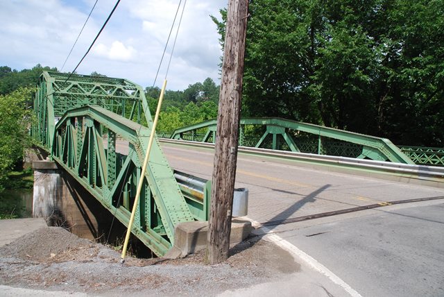
Sutton Bridge

Primary Photographer(s): Nathan Holth
Bridge Documented: July 2, 2013 and June 5, 2014
Sutton: Braxton County, West Virginia: United States
Metal 8 Panel Rivet-Connected Parker Through Truss, Fixed and Approach Spans: Metal 8 Panel Rivet-Connected Polygonal Warren Pony Truss, Fixed
1931 By Builder/Contractor: American Bridge Company of New York, New York
1991
180.0 Feet (54.9 Meters)
369.0 Feet (112.5 Meters)
30 Feet (9.14 Meters)
1 Main Span(s) and 2 Approach Span(s)
4A074

View Information About HSR Ratings
Bridge Documentation
View Archived National Bridge Inventory Report - Has Additional Details and Evaluation
This bridge is a good example of a state standard truss bridge in West Virginia. It is a nice looking bridge with pleasing variety. Not only does its variety of truss designs (Polygonal Warren pony and Parker through) add interest to the bridge, the placement of one pony truss at each end of the bridge creates a nice look to the bridge with the largest span in the center. Its general design from truss configurations to composition of railings and truss members are typical for state-designed truss bridges in West Virginia. This example, including both a through truss and pony truss approach spans is a particularly comprehensive documentation of state bridge engineering.
The portal bracing has been altered to increase clearance, but otherwise the bridge retains good historic integrity with no major alterations detected. The bridge's wide 30 foot roadway makes the bridge a good candidate for preservation for continued vehicular use.
The plaque on the bridge lists the American Bridge Company of Pittsburgh, Pennsylvania as fabricator of the bridge. It is assumed this means the prolific company that usually listed New York City as its headquarters, and the reference to Pittsburgh is referring to which of the company's multiple fabrication facilities made this bridge. The plaque also noted the on-site contractor who erected the bridge as N. H. Clark of Luray, Virginia.
![]()
Photo Galleries and Videos: Sutton Bridge
June 5, 2014 Bridge Photo-Documentation
Original / Full Size PhotosA collection of overview and detail photos. This gallery offers photos in the highest available resolution and file size in a touch-friendly popup viewer.
Alternatively, Browse Without Using Viewer
![]()
June 5, 2014 Bridge Photo-Documentation
Mobile Optimized PhotosA collection of overview and detail photos. This gallery features data-friendly, fast-loading photos in a touch-friendly popup viewer.
Alternatively, Browse Without Using Viewer
![]()
July 2, 2013 Bridge Photo-Documentation
Original / Full Size PhotosA collection of overview and detail photos. This gallery offers photos in the highest available resolution and file size in a touch-friendly popup viewer.
Alternatively, Browse Without Using Viewer
![]()
July 2, 2013 Bridge Photo-Documentation
Mobile Optimized PhotosA collection of overview and detail photos. This gallery features data-friendly, fast-loading photos in a touch-friendly popup viewer.
Alternatively, Browse Without Using Viewer
![]()
Maps and Links: Sutton Bridge
Coordinates (Latitude, Longitude):
Search For Additional Bridge Listings:
Bridgehunter.com: View listed bridges within 0.5 miles (0.8 kilometers) of this bridge.
Bridgehunter.com: View listed bridges within 10 miles (16 kilometers) of this bridge.
Additional Maps:
Google Streetview (If Available)
GeoHack (Additional Links and Coordinates)
Apple Maps (Via DuckDuckGo Search)
Apple Maps (Apple devices only)
Android: Open Location In Your Map or GPS App
Flickr Gallery (Find Nearby Photos)
Wikimedia Commons (Find Nearby Photos)
Directions Via Sygic For Android
Directions Via Sygic For iOS and Android Dolphin Browser
USGS National Map (United States Only)
Historical USGS Topo Maps (United States Only)
Historic Aerials (United States Only)
CalTopo Maps (United States Only)


