

View Information About HSR Ratings
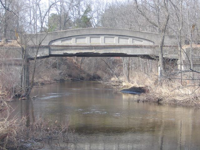
The Echo Drive Bridge, built in 1922-1923, is among the older examples of Michigan's beautiful and historic concrete camelbacks, also known as curved chord through girder bridges. The Echo Drive Bridge is an example of the 50 foot plan, which was the second smallest size included in the set of state standard plans for this bridge type. The smallest size was the 40 foot plan. Echo Drive used to be an alignment for M-20, and as such the plaques on the bridge list the bridge as a Trunk Line Bridge.
Bridge Condition
Areas of repair, particularly the patching of concrete at the ends of the girders, indicate that the bridge has suffered spalling in the past which has been arrested, although the quality of the repair is unknown. The faces of the girders also have exposed rebar, the result of either delamination or spalling. Aside from this however, the bridge appears to be in decent condition.
Despite the above observations, the bridge has a surprisingly low National Bridge Inventory inspection rating of "Serious" for both the deck and the superstructure (girders), which has led to a 2% sufficiency rating for the bridge. These ratings usually result in a bridge which is at risk for demolition, even if preservation might be feasible. Overall, the girder condition visually appears much better than the rating given by the National Bridge Inventory. If the bridge's "Serious" rating is in fact deserved, it is from deterioration which is not readily visible. The bridge listed in the National Bridge Inventory as a "Segmental box girder" which is incorrect, and as such, this makes it hard to not call into question the accuracy of the inspection results as well. Sometimes, a lack of understanding about historic bridges has led to their being evaluated at a capacity and condition that is lower than reality.
There is dirt buildup along the edges of the deck next to the girders, which is substantial enough to support weeds. This should all be removed from the bridge deck, an easy fix that will reduce the presence of moisture on the bridge.
Finally, although the practice is widespread, an asphalt wearing surface has been placed upon the concrete deck of the bridge. It is the opinion of HistoricBridges.org that the problems caused by laying asphalt on top of concrete decks on historic bridges (moisture entrapment, lack of inspection/repair access) outweigh any benefit that such a surface may provide.
Preservation Alternatives
Optimally, the bridge would be rehabilitated for continued vehicular use. However, if it is determined that the bridge is in a condition that makes preservation for continued vehicular use not feasible, than HistoricBridges.org recommends bypassing the historic bridge with a new bridge and leaving the historic bridge in place as either a pedestrian crossing or an abandoned relic closed to all traffic.
Newaygo County's Solution: Demolition
Despite the fact that the Echo Drive Bridge was the only highway bridge in the entire county with any significant heritage value, the county road commission elected to demolish this bridge and replace it with a slab of concrete in 2010. Thanks to Newaygo County, Michigan's once-proud and impressive collection of concrete camelback bridges is one step closer to near-extinction. Never again will this unique and beautiful form of bridge grace Newaygo County. Because there are no other noteworthy historic bridges in Newaygo County, there is nothing that the county can do to make up for this loss, with the exception of relocating a historic bridge into the county from another county or state.
Michigan's Concrete Camelback Bridges
All of Michigan's surviving curved chord through girders should be considered historically and technologically significant. The bridges are historically significant because they represent a unique and innovative design developed by the Michigan State Highway Department in its earlier years of bridge construction.
The bridges should be considered technologically significant as well. By incorporating a curve into the design, Michigan State Highway Department not only increased the efficiency of the design, they also greatly increased the aesthetic value of the bridges. The graceful curves of this bridge type, complemented by architectural details such as inset rectangles make them among the most aesthetically pleasing of bridge types ever encountered. Straight chord through girder bridges are generally considered among the more plain and less visually appealing types of historic bridges. The aesthetic qualities of the curved girder bridge, those qualities being an integral and functional part of the bridge and not a decorative facade, should be considered to be a technologically significant feat: an extremely effective union of function and form.
Statewide, very few examples of this bridge type have been preserved or have evidence of a preservation commitment. Further, the number of examples of this bridge type have been dropping rapidly over the years. Considering that in recent years, Michigan has begun to emerge as a leader in truss bridge preservation, it is reasonable to consider concrete camelback bridges to be the most threatened type of historic bridge in Michigan.
The bridge type has become rare through attrition in Michigan, and the rarity of the bridges today only adds to the significance of those remaining examples.
![]()
![]()
![]()
This historic bridge has been demolished. This map is shown for reference purposes only.
Coordinates (Latitude, Longitude):
Search For Additional Bridge Listings:
Bridgehunter.com: View listed bridges within 0.5 miles (0.8 kilometers) of this bridge.
Bridgehunter.com: View listed bridges within 10 miles (16 kilometers) of this bridge.
Additional Maps:
Google Streetview (If Available)
GeoHack (Additional Links and Coordinates)
Apple Maps (Via DuckDuckGo Search)
Apple Maps (Apple devices only)
Android: Open Location In Your Map or GPS App
Flickr Gallery (Find Nearby Photos)
Wikimedia Commons (Find Nearby Photos)
Directions Via Sygic For Android
Directions Via Sygic For iOS and Android Dolphin Browser
USGS National Map (United States Only)
Historical USGS Topo Maps (United States Only)
Historic Aerials (United States Only)
CalTopo Maps (United States Only)

© Copyright 2003-2025, HistoricBridges.org. All Rights Reserved. Disclaimer: HistoricBridges.org is a volunteer group of private citizens. HistoricBridges.org is NOT a government agency, does not represent or work with any governmental agencies, nor is it in any way associated with any government agency or any non-profit organization. While we strive for accuracy in our factual content, HistoricBridges.org offers no guarantee of accuracy. Information is provided "as is" without warranty of any kind, either expressed or implied. Information could include technical inaccuracies or errors of omission. Opinions and commentary are the opinions of the respective HistoricBridges.org member who made them and do not necessarily represent the views of anyone else, including any outside photographers whose images may appear on the page in which the commentary appears. HistoricBridges.org does not bear any responsibility for any consequences resulting from the use of this or any other HistoricBridges.org information. Owners and users of bridges have the responsibility of correctly following all applicable laws, rules, and regulations, regardless of any HistoricBridges.org information.
![]()