

View Information About HSR Ratings

This bridge was apparently officially named the Beechwood Boulevard Bridge, but is today listed as being on Greenfield Road and is commonly called the Greenfield Bridge. It is simply an indication of how roads and road names are sometimes reconfigured over the life of a bridge.
Countless historic bridges have been neglected and/or demolished and replaced for no other reason than that the system for funding bridge projects in the United States is severely flawed and encourages agencies to defer maintenance and rehabilitation until the bridge deteriorates to a serious condition, at which point those agencies are rewarded with demolition and full replacement funds from the federal government. This system has destroyed history, wasted tax dollars, and probably reduced safety as well. The system need considerable reform, so that greater quantities of funding are provided from the federal government to state and local agencies for the purpose of bridge maintenance and rehabilitation, thus reducing the need for costly, destructive, and inconvenient replacement projects. At the same time, state and local agencies should have to pay a larger percentage of the cost for replacing a bridge, which would decrease the incentive for deferring maintenance and letting a bridge deteriorate.
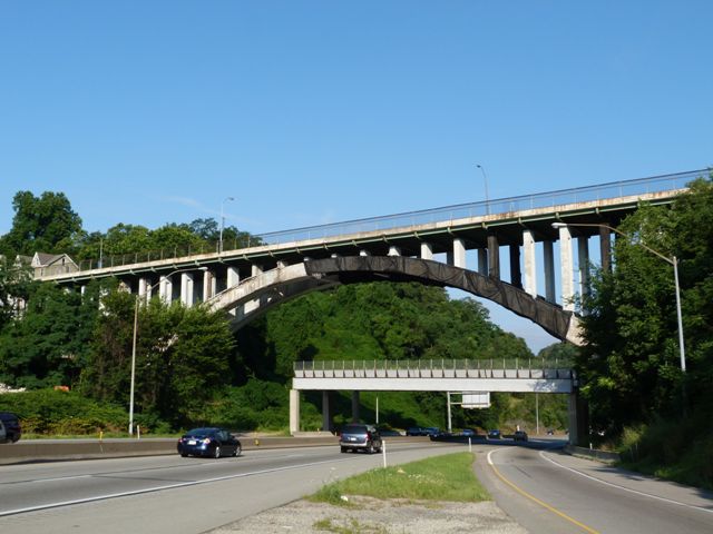
There is perhaps no better example of the flawed funding system than the Beachwood Boulevard Bridge, commonly known as the Greenfield Bridge. Rather than spend money on repairing and rehabilitating the bridge, the bridge's maintenance was deferred to the point that the bridge started dropping concrete onto the freeway below posing a serious safety hazard. One driver was hit in the face with a piece that dropped right through the car windshield. Such an incident would have been prevented if greater amount of funding was available to maintain and rehabilitate old and historic bridges. However, the story gets worse. Because funding to execute a comprehensive rehabilitation of the bridge was unavailable to Pittsburgh, they spent $700,000 to build a bridge under a bridge... a structure that is located underneath part of the historic bridge to catch any concrete debris that might fall from the bridge. The eastbound freeway traffic passes underneath this structure. Essentially, because of our nation's flawed funding system, $700,000 was spent because of this bridge, yet not a single dollar went to improving the bridge itself. This all because rehabilitation funds were not available. Netting was also wrapped around the part of the arch ring which was most deteriorated. The netting is black in color and has reduced the aesthetic quality of the bridge.

HistoricBridges.org does want to make it very clear that despite the falling concrete and all the measures taken in response to it, that the overall structural condition and stability of the bridge is decent. Many bridges in much poorer structural condition remain open to traffic. The falling concrete, while it was dangerous to anyone under it, has not severely reduced the strength of the bridge, although it may increase the rate at which the reinforcing deteriorates in the years to come, now that it is likely exposed in several areas.
Now, the future of the bridge is to be reduced to rubble, since the city plans to demolish this historic bridge. Although the bridge has been severely altered, and as such as relatively poor historic integrity, several historic elements do remain on the bridge, and it contributes to the vast bridge heritage present in Pittsburgh by offering a structure that is readily visible to the large number of people traveling on I-376. It also adds to the aesthetic value of the adjacent historic Schenley Park.
The bridge is slated to be replaced with a steel deck arch bridge. It appears that this replacement bridge will have railings designed to be similar to those that were originally on the historic bridge.
Information and Findings From Pennsylvania's Historic Bridge InventoryDiscussion of Bridge The 13-span, 466'-long bridge built in 1922 consists of a 270'-long ribbed open spandrel arch span and 12 steel stringer approach spans supported on concrete abutments and piers. The bridge underwent significant alterations in 1980 including removal of all of the original fabric of the arch span from the ribs up including the spandrel columns, floorbeams, deck, and the Classical-style concrete balustrades with urn balusters. The spandrel columns were replaced in kind, but steel stringers and a stay-in-place steel deck were used in place of reinforced concrete for the flooring system. The balustrades were replaced by safety shape parapets and chain link fences. The approach spans were also replaced as part of the project with steel stringer spans used in place of concrete slab spans. Allegheny County has one of the state's most impressive collections of open spandrel arch bridges with 13 identified examples dating from 1912 to 1950. This 1922 example has lost integrity of original design. Other more complete examples represent the significance of the bridge type in the county and regional contexts. Discussion of Surrounding Area The bridge carries a 3 lane street over a 6 lane, limited access highway. The north end of the bridge is adjacent to Schenley Park (NR-listed 11/13/1985). The historic district's boundaries coincide with the park's boundaries, and bridge is contiguous to but not within the district. Although several bridges were listed as contributing to the district, this one was not included. At the bridge's southern quadrants is a late-20th-century commercial strip. Bridge Considered Historic By Survey: No |
![]()
![]()
![]()
This historic bridge has been demolished. This map is shown for reference purposes only.
Coordinates (Latitude, Longitude):
Search For Additional Bridge Listings:
Bridgehunter.com: View listed bridges within 0.5 miles (0.8 kilometers) of this bridge.
Bridgehunter.com: View listed bridges within 10 miles (16 kilometers) of this bridge.
Additional Maps:
Google Streetview (If Available)
GeoHack (Additional Links and Coordinates)
Apple Maps (Via DuckDuckGo Search)
Apple Maps (Apple devices only)
Android: Open Location In Your Map or GPS App
Flickr Gallery (Find Nearby Photos)
Wikimedia Commons (Find Nearby Photos)
Directions Via Sygic For Android
Directions Via Sygic For iOS and Android Dolphin Browser
USGS National Map (United States Only)
Historical USGS Topo Maps (United States Only)
Historic Aerials (United States Only)
CalTopo Maps (United States Only)

© Copyright 2003-2026, HistoricBridges.org. All Rights Reserved. Disclaimer: HistoricBridges.org is a volunteer group of private citizens. HistoricBridges.org is NOT a government agency, does not represent or work with any governmental agencies, nor is it in any way associated with any government agency or any non-profit organization. While we strive for accuracy in our factual content, HistoricBridges.org offers no guarantee of accuracy. Information is provided "as is" without warranty of any kind, either expressed or implied. Information could include technical inaccuracies or errors of omission. Opinions and commentary are the opinions of the respective HistoricBridges.org member who made them and do not necessarily represent the views of anyone else, including any outside photographers whose images may appear on the page in which the commentary appears. HistoricBridges.org does not bear any responsibility for any consequences resulting from the use of this or any other HistoricBridges.org information. Owners and users of bridges have the responsibility of correctly following all applicable laws, rules, and regulations, regardless of any HistoricBridges.org information.
![]()