

View Information About HSR Ratings
This bridge is part of an interesting historic bridge history Below is a short summary of a series of events of which this bridge is a part. Consider the narrative below.
There are three bridges that are discussed in this article:
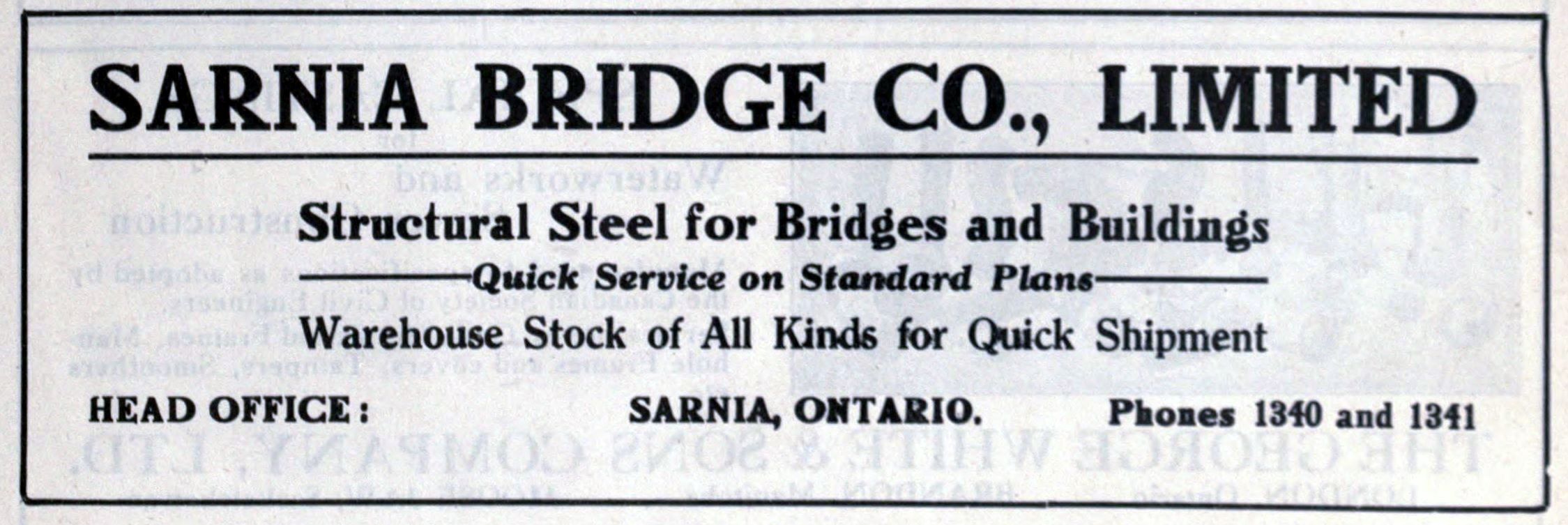
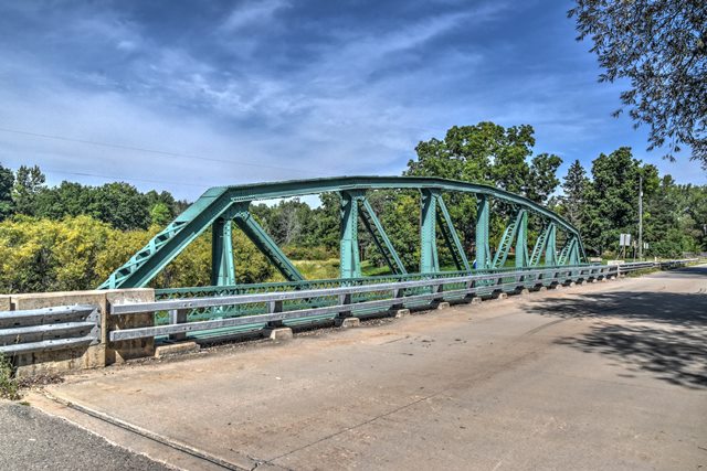
Back in 1920, Gratiot Road was US-25, a major route connecting Port Huron and Detroit. A bridge was needed to cross the Belle River in St. Clair County, and a pony Parker truss was selected and built there. The bridge was fabricated, and perhaps designed as well, by the Sarnia Bridge Company. In 1927, up in Midland County, this Irish Street Bridge was constructed to carry US-10 over the Salt River. By 1931, Gratiot Road (US-25) was becoming increasingly busy. It was decided that a new beam bridge would be needed there. As a result, the concrete Belle River Bridge was constructed. This is most likely the time when a center lane was added to US-25 to serve as a passing lane for both directions of traffic. The center lane would later be known as a death-lane due to deadly head-on collisions that it caused as a shared passing lane. Gratiot today no longer has that lane, but all the old bridges are wider than the current two-lane road because of this former lane. The wider width of the roadway needed for this passing lane may have been what made the two lane truss bridge, which had only been in service for 12 years, inadequate for the roadway. As a result, a three-lane beam bridge was constructed right beside the parker truss bridge, on the northern side. The truss bridge likely remained open to traffic while this bridge was built. The Parker truss abutments still remain right next to the beam bridge even today, which lead to this assumption. Meanwhile in Midland County, a realignment had been designed for US-10, which relocated the Salt River crossing south a little ways, next to the Pere Marquette Railroad tracks; the site of current day North Saginaw Road. It was decided that the truss bridge from US-25 would work fine for US-10, and it was relocated to the new US-10 crossing in 1932. A standard Michigan State Highway Department Plaque was placed on the abutment for the bridge in Midland County to credit the 1932 repairs and substructure construction. As a result of all this, the Irish Street Bridge, now former US-10 alignment, reverted to local control, having been a trunk line bridge for only five years. The parker truss bridge from St. Clair County likely served US-10 traffic until the US-10 expressway was completed. Upon completion of the US-10 Expressway, North Saginaw Road ceased to be US-10 and was reverted to local control. A side effect of this, would have been reduced traffic on North Saginaw Road, which allowed the truss bridge to still be a viable crossing up to modern times. Recently, Midland County Road Commission decided to replace the Parker truss bridge. The Parker truss bridge was once again relocated and restored, ending up this time on Perrine Road north of the US-10 expressway near Midland. The Parker truss bridge remains open to traffic today in this location.
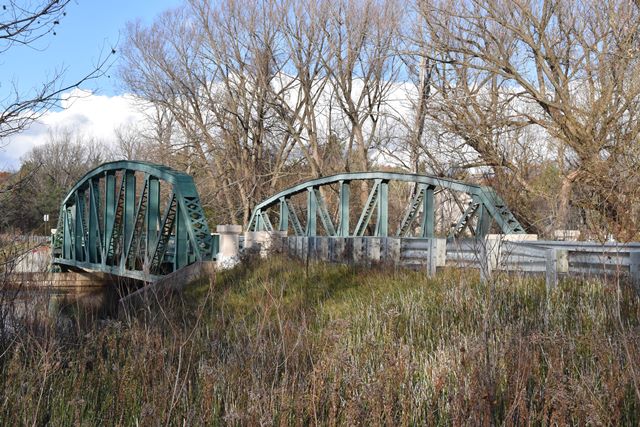
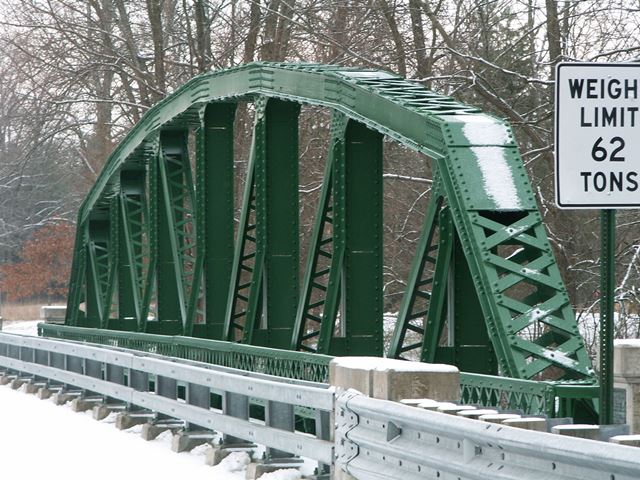
This bridge is a large span example of a Michigan State Highway Department standard pony truss bridge. It displays the typical details of the bridge type, but is one of the largest spanning examples of its type. Despite two moves, the bridge retains good historic integrity. Most noteworthy, during the most recent move the historic integrity of the bridge was maintained. The only exception would be the use of bolts on the connections where the truss was separated for relocation. These would have originally been rivets. The deck that consists of the unusual design of a steel plate base is retained. This plate base is covered with concrete on top. Look under the bridge to see the steel plate. Original railings remain on the bridge, and low profile crash-tested two tube railing is present in front of the original railing to protect the trusses. This is an outstanding preservation outcome and Midland County deserves to be thanked for preserving this bridge.
The bridge is additionally significant as one of the only bridges in the United States to have been built by a Canadian company, as well as one of the only bridges to be built using Canadian steel.
Information and Findings From Michigan Historic Sites OnlineNarrative Description
Main span number: 1 Main span length: 109 Structure length: 115 Roadway width: 30 Structure width: 37 The North Saginaw Road Bridge over the Salt River is located about one-half mile northwest of Sanford in Jerome Township. The area surrounding the bridge is dominated by thick woods. Steep banks covered with undergrowth lead down to the river. Immediately southwest of the bridge is an abandoned railroad bridge, and about 150 yards to the northeast lies a concrete, curved-chord, through girder bridge. The North Saginaw Road Bridge is oriented on a northwest-to-southwest axis; for the sake of clarity, the following description assumes a north-south position. The bridge is a steel, eight-panel, riveted Parker pony truss. The single span has a length of 109 feet. The overall length of the bridge is 115 feet. Raised steel plates form narrow sidewalks and provide the curbing for the 30-foot-wide roadway. Steel plates make up the deck. The polygonal upper chord is formed by back-to-back channels tied with lacing, with battens near the panel intersections. The lower chord consists of two pairs of back-to-back angles connected by lacing. Two pairs of back-to-back angles joined by large plates form the verticals. Diagonals are made of two paris of back-to-back angles ties with lacing. Knee braces are formed by back-to-back angles. Two angels with latticework from the railings. The railings end at concrete corner posts. Detached armco guardrails extend from all but the northwest corner. The steelmaker's marks include "ALGOMA STEEL CANADA" and "ALGOMA" steel I-beam stringers, riveted to the superstructure, are used for floor beams. The stringers are also I-beams, which are bolted to the floor beams. Roller bearings at the north end allow for expansion. Concrete abutments support the structure. The back and wingwalls are also concrete. Bottom lateral bracing is provided by angles. The physical condition of the bridge is good, and the historical integrity has been maintained. Statement of Significance The North Saginaw Road Bridge was erected in 1920 to carry U.S. 25 over the Belle River in St. Clair County. Original bridge plans show that two identical federal-aid bridge were built that year in St. Clair County. These are two of the first three Parker low trusses built in Michigan. Both the Sarnia Bridge Company, Sarnia, Ontario, and the Michigan State Highway Department are listed on the plans. Since the Sarnia Bridge company's name is prominent, the firm may have been involved with the design in addition to fabricating the superstructure. When the Belle River Bridge became inadequate for its original site, it was moved in 1932 to Midland County where a portion of U.S. 10 was being relocated and a new bridge was needed. Materials that were added or replaced in 1932 included floor beams, about a third of the stringers, floor plates, laterals, transverse beams, curb angles and abutments. To accommodate its new site, the bridge roadway was widened from 20 feet to 30 feet. The new floor consisted of welded steel plates, called a battledeck floor. The state had only begun using this type of flooring system during the 1931-1932 biennium, so this bridge is apparently one of the first examples. The North Saginaw Road Bridge is one of the first examples of a Parker pony truss built in Michigan and is one of only a few remaining. The only example built before the North Saginaw Bridge and its twin is the Hemlock Road Bridge over the North Branch of the Bad River in Saginaw County. Additionally, this bridge is significant for being one of the first bridges to have a welded steel plate floor, which was added after the bridge was moved. The North Saginaw Road Bridge has thus been determined eligible for the National Register under Criterion C. |
This bridge is tagged with the following special condition(s): Unorganized Photos
![]()
![]()
![]()
![]()
![]()
Coordinates (Latitude, Longitude):
Search For Additional Bridge Listings:
Bridgehunter.com: View listed bridges within 0.5 miles (0.8 kilometers) of this bridge.
Bridgehunter.com: View listed bridges within 10 miles (16 kilometers) of this bridge.
Additional Maps:
Google Streetview (If Available)
GeoHack (Additional Links and Coordinates)
Apple Maps (Via DuckDuckGo Search)
Apple Maps (Apple devices only)
Android: Open Location In Your Map or GPS App
Flickr Gallery (Find Nearby Photos)
Wikimedia Commons (Find Nearby Photos)
Directions Via Sygic For Android
Directions Via Sygic For iOS and Android Dolphin Browser
USGS National Map (United States Only)
Historical USGS Topo Maps (United States Only)
Historic Aerials (United States Only)
CalTopo Maps (United States Only)

© Copyright 2003-2025, HistoricBridges.org. All Rights Reserved. Disclaimer: HistoricBridges.org is a volunteer group of private citizens. HistoricBridges.org is NOT a government agency, does not represent or work with any governmental agencies, nor is it in any way associated with any government agency or any non-profit organization. While we strive for accuracy in our factual content, HistoricBridges.org offers no guarantee of accuracy. Information is provided "as is" without warranty of any kind, either expressed or implied. Information could include technical inaccuracies or errors of omission. Opinions and commentary are the opinions of the respective HistoricBridges.org member who made them and do not necessarily represent the views of anyone else, including any outside photographers whose images may appear on the page in which the commentary appears. HistoricBridges.org does not bear any responsibility for any consequences resulting from the use of this or any other HistoricBridges.org information. Owners and users of bridges have the responsibility of correctly following all applicable laws, rules, and regulations, regardless of any HistoricBridges.org information.
![]()
