

View Information About HSR Ratings
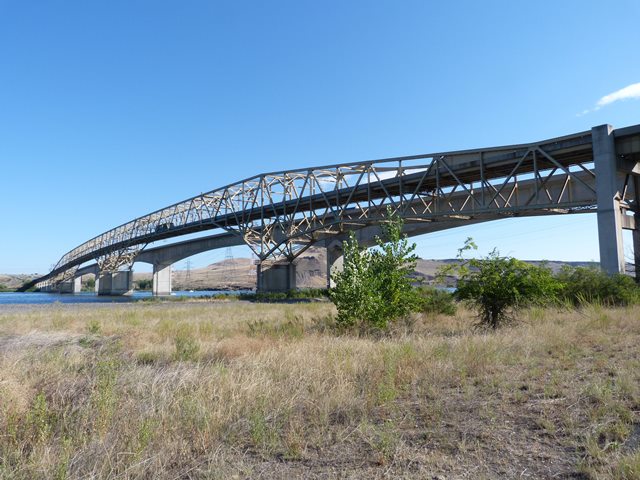
This bridge is a very unusual and distinctive cantilever truss because it includes two spans that each consist of cantilever arms holding a suspended span in the center. Most bridges of this type only have one cantilever arm/suspended span component. To accommodate this unusual design, an equally unusual and short-looking 300 foot span can be found in the middle of the river acting as anchor arms for each of the central cantilever arms that extend from that point. Each cantilever arm is 150 feet long and the suspended span is 300 feet. The truss has an uncommon design that begins as a deck truss and rises to act as a through truss over the channel spans.
Tudor Engineering Company designed the bridge. Austin Construction and Cascade Construction Companies both from Portland, Oregon built the piers and approaches. The American Bridge Company was the steel fabricator.
Today the bridge only carries southbound (I-82 Eastbound) traffic with a modern (and hideously ugly) bridge carrying northbound traffic right next to the bridge. It would have been nice to see some sensitivity to aesthetics of the historic bridge when the new bridge was built. A bridge that didn't block the view and compete with the appearance of the historic bridge would have been nice as was done in Michigan with the Blue Water Bridge.

![]()
![]()
![]()
Coordinates (Latitude, Longitude):
Search For Additional Bridge Listings:
Bridgehunter.com: View listed bridges within 0.5 miles (0.8 kilometers) of this bridge.
Bridgehunter.com: View listed bridges within 10 miles (16 kilometers) of this bridge.
Additional Maps:
Google Streetview (If Available)
GeoHack (Additional Links and Coordinates)
Apple Maps (Via DuckDuckGo Search)
Apple Maps (Apple devices only)
Android: Open Location In Your Map or GPS App
Flickr Gallery (Find Nearby Photos)
Wikimedia Commons (Find Nearby Photos)
Directions Via Sygic For Android
Directions Via Sygic For iOS and Android Dolphin Browser
USGS National Map (United States Only)
Historical USGS Topo Maps (United States Only)
Historic Aerials (United States Only)
CalTopo Maps (United States Only)

© Copyright 2003-2024, HistoricBridges.org. All Rights Reserved. Disclaimer: HistoricBridges.org is a volunteer group of private citizens. HistoricBridges.org is NOT a government agency, does not represent or work with any governmental agencies, nor is it in any way associated with any government agency or any non-profit organization. While we strive for accuracy in our factual content, HistoricBridges.org offers no guarantee of accuracy. Information is provided "as is" without warranty of any kind, either expressed or implied. Information could include technical inaccuracies or errors of omission. Opinions and commentary are the opinions of the respective HistoricBridges.org member who made them and do not necessarily represent the views of anyone else, including any outside photographers whose images may appear on the page in which the commentary appears. HistoricBridges.org does not bear any responsibility for any consequences resulting from the use of this or any other HistoricBridges.org information. Owners and users of bridges have the responsibility of correctly following all applicable laws, rules, and regulations, regardless of any HistoricBridges.org information.
![]()