

View Information About HSR Ratings
Midgley Bridge is a historic deck arch bridge located near Sedona, Arizona, spanning Wilson Canyon along State Route 89A. The bridge was constructed in 1938-1939 as the final link in a major infrastructure upgrade of the Oak Creek Highway between Sedona and Flagstaff. The U.S. Bureau of Public Roads (BPR) initiated the project under Arizona Forest Project 7, dividing it into multiple contracts during the early 1930s. Midgley Bridge was the last component needed to complete the new roadway.
Designed by BPR engineers, the bridge was built by Lewis Brothers of Phoenix, Arizona. Construction began on March 24, 1938, with excavation for the arch pedestals in the canyon. The steel structure was completed by October 31, 1938, under the supervision of BPR Resident Engineer V.G. Watson. The bridge was named in honor of W.W. Midgley, a local rancher from the 19th century who contributed to the development of the region.
Since its completion, the bridge has remained largely unaltered except for the addition of modern steel thrie-beam railings attached to the original guardrails. It continues to serve as a vital link on US 89A, providing a scenic and historically significant crossing over Wilson Canyon.
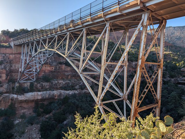
Midgley Bridge is a two-hinged, spandrel-braced steel deck arch with a total length of 374 feet (114 meters) and a main span of 240 feet (73.2 meters). The bridge’s design resembles a scaled-down version of the Navajo Bridge (1929), another prominent deck arch in Arizona.
Key structural elements include:
Arch Structure: The steel arch consists of two built-up box beams composed of twin channels with double lacing on the top and bottom.
Superstructure: The arch supports a reinforced concrete deck resting on a series of I-beam steel floor beams, which in turn are supported by W-beam and built-up columns.
Substructure: The bridge is anchored by reinforced concrete abutments and arch pedestals, with stone masonry wingwalls enhancing its visual appeal.
Deck and Guardrails: The deck width measures 27.2 feet (8.3 meters), with a roadway width of 24 feet (7.3 meters). The bridge originally had steel guardrails, later reinforced with modern thrie beams for improved safety.
The structure is functionally classified as a principal arterial (rural) and has a daily traffic count of approximately 3,858 vehicles as of 2016. It remains open with no restrictions but has been deemed functionally obsolete due to its outdated deck geometry.
Midgley Bridge holds historical and engineering significance due to its rare deck arch configuration and its role in completing the Oak Creek Highway. While Arizona has numerous long-span steel arches, only the Navajo Bridge and Midgley Bridge feature spandrel-braced arches, making them unique among the state’s historic bridges.
The bridge is considered potentially eligible for the National Register of Historic Places (NRHP) due to its association with:
Transportation History: It served as the final connection between Sedona and Flagstaff, enhancing regional mobility and economic development.
Engineering and Design: It represents a well-preserved example of an esoteric and dramatic structural type that was uncommon in the region.
Scenic and Cultural Importance: Located in a striking natural setting, Midgley Bridge contributes to the historic and aesthetic landscape of Arizona’s red rock country.
The Midgley Bridge remains an important regional landmark and a testament to early 20th-century bridge engineering in Arizona.
![]()
![]()
![]()
Coordinates (Latitude, Longitude):
Search For Additional Bridge Listings:
Bridgehunter.com: View listed bridges within 0.5 miles (0.8 kilometers) of this bridge.
Bridgehunter.com: View listed bridges within 10 miles (16 kilometers) of this bridge.
Additional Maps:
Google Streetview (If Available)
GeoHack (Additional Links and Coordinates)
Apple Maps (Via DuckDuckGo Search)
Apple Maps (Apple devices only)
Android: Open Location In Your Map or GPS App
Flickr Gallery (Find Nearby Photos)
Wikimedia Commons (Find Nearby Photos)
Directions Via Sygic For Android
Directions Via Sygic For iOS and Android Dolphin Browser
USGS National Map (United States Only)
Historical USGS Topo Maps (United States Only)
Historic Aerials (United States Only)
CalTopo Maps (United States Only)

© Copyright 2003-2026, HistoricBridges.org. All Rights Reserved. Disclaimer: HistoricBridges.org is a volunteer group of private citizens. HistoricBridges.org is NOT a government agency, does not represent or work with any governmental agencies, nor is it in any way associated with any government agency or any non-profit organization. While we strive for accuracy in our factual content, HistoricBridges.org offers no guarantee of accuracy. Information is provided "as is" without warranty of any kind, either expressed or implied. Information could include technical inaccuracies or errors of omission. Opinions and commentary are the opinions of the respective HistoricBridges.org member who made them and do not necessarily represent the views of anyone else, including any outside photographers whose images may appear on the page in which the commentary appears. HistoricBridges.org does not bear any responsibility for any consequences resulting from the use of this or any other HistoricBridges.org information. Owners and users of bridges have the responsibility of correctly following all applicable laws, rules, and regulations, regardless of any HistoricBridges.org information.
![]()