

View Information About HSR Ratings
Disclaimer: Generated with the aid of ChatGPT AI, the below narrative is based on sources provided by Nathan Holth and crafted to align with his research and passion for historic bridges.
The Colorado River, carving through the heart of the Grand Canyon, had long posed an almost insurmountable obstacle to transportation. For centuries, Native Americans, explorers, and settlers relied on precarious crossings such as Lee’s Ferry, where the treacherous waters of the river often made passage difficult and dangerous. By the early 20th century, as automobile travel increased and Arizona sought to connect its northern and southern regions, the need for a permanent bridge became critical.
At the time, the nearest bridges over the Colorado River were hundreds of miles away, forcing travelers to endure long, inefficient detours. The state of Arizona, recognizing the economic and logistical benefits of a bridge at Marble Canyon, initiated plans to construct what would become the first permanent vehicle crossing of the Colorado River in Arizona.
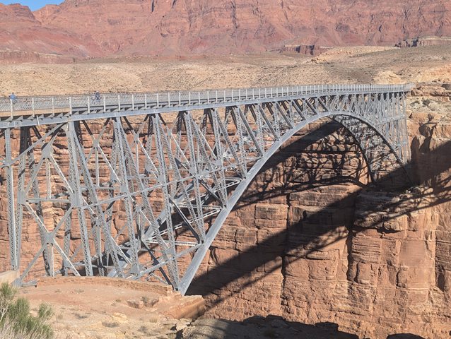
The Navajo Bridge was constructed between 1927 and 1929, designed by Ralph A. Hoffman, the bridge engineer for the Arizona Highway Department. Unlike earlier designs considered for the crossing—such as a suspension bridge—Hoffman opted for a deck arch configuration, which would offer superior strength, durability, and resistance to the extreme environmental conditions of the Grand Canyon.
The Kansas City Structural Steel Company fabricated and erected the steel superstructure, while the Arizona Highway Department handled foundation work. The bridge’s construction required overcoming significant logistical challenges, as all materials had to be transported over rough, undeveloped roads for 130 miles from Flagstaff. The high desert climate added further difficulties, with extreme temperature swings from scorching heat to freezing cold.
Height Above River: 467 feet (at the time of completion, it was one of the highest bridges in the world)
Material Used: Over 2 million pounds of steel and over 500 cubic yards of concrete
Cost: $330,000 (equivalent to $5 million+ today)
Construction involved cantilevering the arch halves from opposite canyon walls, a delicate process requiring precision engineering. On September 12, 1928, workers completed the final connection in the center of the arch, marking a significant milestone. The bridge officially opened on January 12, 1929, dramatically improving travel efficiency across the region.
Before the bridge, travelers moving between Utah and Arizona relied on Lee’s Ferry, where river crossings were slow, unpredictable, and often perilous. The Navajo Bridge revolutionized transportation, allowing automobiles to cross without delay or risk, significantly reducing travel times between the Four Corners region and northern Arizona.
The bridge also facilitated increased tourism to the Grand Canyon and Glen Canyon, helping establish Arizona as a major destination for travelers. Additionally, it played a crucial role in linking remote communities, including Navajo and Hopi lands, to the expanding highway network.
The completion of U.S. Route 89A, which incorporated the bridge, further solidified its importance. Over time, the Navajo Bridge became an essential route for commerce, enabling the transport of goods between northern Arizona and southern Utah.
By the late 20th century, the original bridge—despite its robust design—was no longer suitable for modern highway traffic. With an 18-foot-wide deck, it was too narrow to accommodate larger, heavier vehicles, including semi-trucks and RVs. In the 1990s, Arizona officials determined that a new bridge was necessary to meet contemporary transportation needs.
Instead of demolishing the historic bridge, preservationists and engineers devised a twin bridge solution. In 1995, the new Navajo Bridge, a wider steel arch with similar aesthetics, was built just downstream of the original. This allowed the historic bridge to be repurposed as a pedestrian viewpoint, offering visitors breathtaking vistas of Marble Canyon and the Colorado River.
Unlike many historic bridges that have been lost to neglect or demolition, the Navajo Bridge remains intact as a beautifully preserved example of early steel-arch engineering. It stands today as a pedestrian and interpretive site, offering visitors a chance to appreciate both its engineering significance and the stunning natural landscape.
The bridge has been recognized for its historic value in multiple ways:
Listed on the National Register of Historic Places (1981)
Recorded by the Historic American Engineering Record (HAER)
Interpreted at the Navajo Bridge Interpretive Center, operated by the National Park Service
The site has become a tourist attraction in its own right, with many visitors stopping to walk across the original bridge, taking in sweeping views of the canyon walls and the emerald-green waters of the Colorado River. It serves as a reminder of the ingenuity and perseverance that shaped Arizona’s transportation history.
For historic bridge enthusiasts, the Navajo Bridge is more than just a span across the Colorado River—it is a monument to American engineering, a symbol of progress in the Southwest, and a testament to the value of preservation. Unlike so many early steel structures that have been demolished and forgotten, the Navajo Bridge endures, allowing modern visitors to experience a piece of 1920s engineering in the heart of one of the most spectacular landscapes in the United States.
For someone like myself, who has spent decades advocating for the preservation of historic bridges, the story of the Navajo Bridge’s survival is one of triumph. It demonstrates that historic bridges can be adaptively reused rather than discarded, allowing future generations to appreciate their craftsmanship and the role they played in shaping our infrastructure. As we continue to navigate an era of rapid development and modernization, the Navajo Bridge stands as a beacon of what can be achieved when we recognize the importance of our engineering heritage.
![]()
![]()
![]()
Coordinates (Latitude, Longitude):
Search For Additional Bridge Listings:
Bridgehunter.com: View listed bridges within 0.5 miles (0.8 kilometers) of this bridge.
Bridgehunter.com: View listed bridges within 10 miles (16 kilometers) of this bridge.
Additional Maps:
Google Streetview (If Available)
GeoHack (Additional Links and Coordinates)
Apple Maps (Via DuckDuckGo Search)
Apple Maps (Apple devices only)
Android: Open Location In Your Map or GPS App
Flickr Gallery (Find Nearby Photos)
Wikimedia Commons (Find Nearby Photos)
Directions Via Sygic For Android
Directions Via Sygic For iOS and Android Dolphin Browser
USGS National Map (United States Only)
Historical USGS Topo Maps (United States Only)
Historic Aerials (United States Only)
CalTopo Maps (United States Only)

© Copyright 2003-2026, HistoricBridges.org. All Rights Reserved. Disclaimer: HistoricBridges.org is a volunteer group of private citizens. HistoricBridges.org is NOT a government agency, does not represent or work with any governmental agencies, nor is it in any way associated with any government agency or any non-profit organization. While we strive for accuracy in our factual content, HistoricBridges.org offers no guarantee of accuracy. Information is provided "as is" without warranty of any kind, either expressed or implied. Information could include technical inaccuracies or errors of omission. Opinions and commentary are the opinions of the respective HistoricBridges.org member who made them and do not necessarily represent the views of anyone else, including any outside photographers whose images may appear on the page in which the commentary appears. HistoricBridges.org does not bear any responsibility for any consequences resulting from the use of this or any other HistoricBridges.org information. Owners and users of bridges have the responsibility of correctly following all applicable laws, rules, and regulations, regardless of any HistoricBridges.org information.
![]()