

View Information About HSR Ratings
Disclaimer: Generated with the aid of ChatGPT AI, the below narrative is based on sources provided by Nathan Holth and crafted to align with his research and passion for historic bridges.
History of the 1931 Tempe Bridge
The 1931 Tempe Bridge, also known as the Mill Avenue Bridge, was constructed to replace an aging 1913 structure that had become inadequate for increasing traffic demands. Prior to the construction of permanent bridges, the Salt River crossing in Tempe was facilitated by Charles Hayden’s ferry service, established in 1874. With the advent of automobiles and Arizona’s growing infrastructure, the need for a more substantial bridge became evident. In response, the Arizona Highway Department planned a modern bridge to accommodate higher traffic volumes and improve regional connectivity.
Construction of the bridge began in 1930 following a competitive bidding process, with the contract awarded to Lynch-Cannon Engineering Company. The bridge was strategically designed to ensure its foundations were anchored in bedrock, avoiding the caliche soil issues that had troubled earlier structures. The total cost of construction amounted to approximately $518,788, with federal funding covering a significant portion. Upon completion in August 1931, the bridge became a critical component of the national transportation network, serving as part of U.S. Routes 60, 80, and 89.
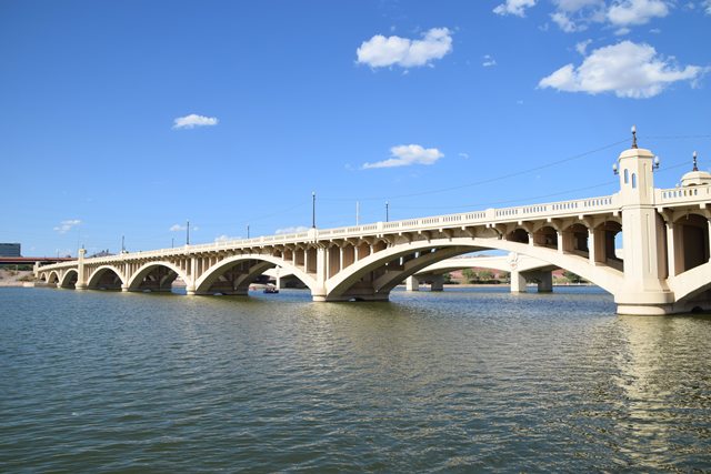
Design and Engineering
The Tempe Bridge is an exemplary representation of early 20th-century bridge engineering. It is a reinforced concrete open-spandrel arch bridge, a design chosen for its strength, aesthetic appeal, and durability. The structure spans a total of 1,577 feet, with ten arches each measuring 140 feet in length. The bridge’s deck width is 46 feet, including a 36-foot roadway and five-foot sidewalks on each side.
One of the bridge’s most distinctive features is its system of multiple ribbed arches with open spandrels, which allow for both structural efficiency and visual elegance. The ribs are reinforced with square steel bars, providing additional strength. The bridge’s piers were designed with two different types: abutment piers, which measure 15 feet in girth, and intermediate piers, measuring 7 feet 6 inches. The hexagonal towers above the piers serve both functional and aesthetic purposes, offering pedestrian rest areas and enhancing the bridge’s architectural character.
Over the decades, the bridge underwent several modifications to maintain its structural integrity and accommodate changing transportation needs. The original lighting system was replaced in 1962, with subsequent upgrades in 1979 to improve nighttime visibility. Despite being subjected to numerous floods, including the major floods of 1965 and 1980, the bridge remained structurally sound, earning the nickname "Old Faithful" due to its resilience.
Historic Significance
The 1931 Tempe Bridge holds considerable historic and engineering significance. It played a vital role in the development of transportation infrastructure in Arizona, serving as a major link between Phoenix and Tempe. The bridge was essential in handling increased traffic volumes, particularly during periods of flooding when other nearby crossings were compromised. Its ability to withstand extreme floodwaters further demonstrated its exceptional engineering.
In addition to its practical significance, the bridge is an outstanding example of open-spandrel arch bridge construction, a style that was relatively rare in Arizona. It remains one of only two such bridges in the state, with its predecessor, the 1913 bridge, having been abandoned and left in a deteriorating state. Recognizing its importance, the bridge was listed on the National Register of Historic Places in 1981.
Today, the construction of the adjacent 1994 Mill Avenue Bridge to carry northbound traffic and create a one-way couplet preservation solution, has allowed the historic bridge to continue to be functional, as well as a cherished landmark. It stands as a testament to early 20th-century engineering ingenuity and continues to be a symbol of Tempe’s rich transportation history.
![]()
![]()
![]()
Coordinates (Latitude, Longitude):
Search For Additional Bridge Listings:
Bridgehunter.com: View listed bridges within 0.5 miles (0.8 kilometers) of this bridge.
Bridgehunter.com: View listed bridges within 10 miles (16 kilometers) of this bridge.
Additional Maps:
Google Streetview (If Available)
GeoHack (Additional Links and Coordinates)
Apple Maps (Via DuckDuckGo Search)
Apple Maps (Apple devices only)
Android: Open Location In Your Map or GPS App
Flickr Gallery (Find Nearby Photos)
Wikimedia Commons (Find Nearby Photos)
Directions Via Sygic For Android
Directions Via Sygic For iOS and Android Dolphin Browser
USGS National Map (United States Only)
Historical USGS Topo Maps (United States Only)
Historic Aerials (United States Only)
CalTopo Maps (United States Only)

© Copyright 2003-2026, HistoricBridges.org. All Rights Reserved. Disclaimer: HistoricBridges.org is a volunteer group of private citizens. HistoricBridges.org is NOT a government agency, does not represent or work with any governmental agencies, nor is it in any way associated with any government agency or any non-profit organization. While we strive for accuracy in our factual content, HistoricBridges.org offers no guarantee of accuracy. Information is provided "as is" without warranty of any kind, either expressed or implied. Information could include technical inaccuracies or errors of omission. Opinions and commentary are the opinions of the respective HistoricBridges.org member who made them and do not necessarily represent the views of anyone else, including any outside photographers whose images may appear on the page in which the commentary appears. HistoricBridges.org does not bear any responsibility for any consequences resulting from the use of this or any other HistoricBridges.org information. Owners and users of bridges have the responsibility of correctly following all applicable laws, rules, and regulations, regardless of any HistoricBridges.org information.
![]()