

View Information About HSR Ratings
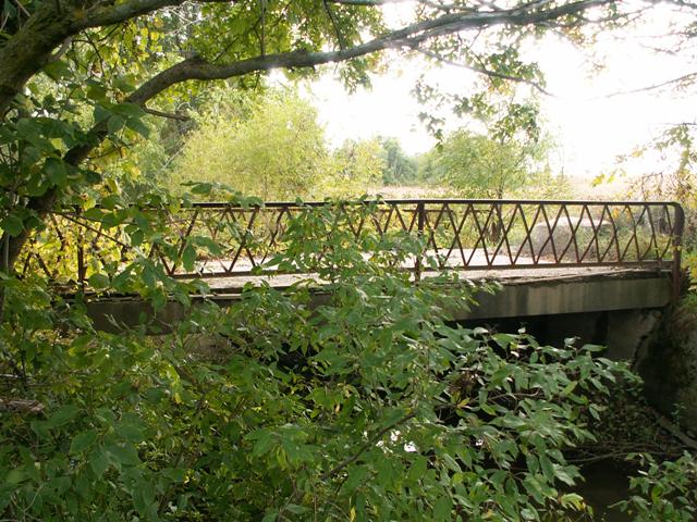
Like metal truss bridges, there is a scattering of old steel stringer beam bridges scattered throughout the state. Most of these seem to have had lattice guardrails, which were mounted in odd ways often with the attachment under the stringers with buttresses holding them steady. This design often led to rust and collision damage and many of the bridges have lost their railings. This bridge is a good example of that design. It features a concrete deck with corrugated steel below, which was known as a jack-arch deck. What makes this bridge unusual is the lattice railings are a different design than usually seen. Perhaps this difference is to the the early construction date of this bridge, which is 1895. Compare this bridge to the demolished 27 Mile Road Beam Bridge in Macomb County.
After having been abandoned for some time, Lenawee County finally demolished this bridge.
This bridge is tagged with the following special condition(s): Unorganized Photos
![]()
![]()
![]()
![]()
This historic bridge has been demolished. This map is shown for reference purposes only.
Coordinates (Latitude, Longitude):
Search For Additional Bridge Listings:
Bridgehunter.com: View listed bridges within 0.5 miles (0.8 kilometers) of this bridge.
Bridgehunter.com: View listed bridges within 10 miles (16 kilometers) of this bridge.
Additional Maps:
Google Streetview (If Available)
GeoHack (Additional Links and Coordinates)
Apple Maps (Via DuckDuckGo Search)
Apple Maps (Apple devices only)
Android: Open Location In Your Map or GPS App
Flickr Gallery (Find Nearby Photos)
Wikimedia Commons (Find Nearby Photos)
Directions Via Sygic For Android
Directions Via Sygic For iOS and Android Dolphin Browser
USGS National Map (United States Only)
Historical USGS Topo Maps (United States Only)
Historic Aerials (United States Only)
CalTopo Maps (United States Only)

© Copyright 2003-2024, HistoricBridges.org. All Rights Reserved. Disclaimer: HistoricBridges.org is a volunteer group of private citizens. HistoricBridges.org is NOT a government agency, does not represent or work with any governmental agencies, nor is it in any way associated with any government agency or any non-profit organization. While we strive for accuracy in our factual content, HistoricBridges.org offers no guarantee of accuracy. Information is provided "as is" without warranty of any kind, either expressed or implied. Information could include technical inaccuracies or errors of omission. Opinions and commentary are the opinions of the respective HistoricBridges.org member who made them and do not necessarily represent the views of anyone else, including any outside photographers whose images may appear on the page in which the commentary appears. HistoricBridges.org does not bear any responsibility for any consequences resulting from the use of this or any other HistoricBridges.org information. Owners and users of bridges have the responsibility of correctly following all applicable laws, rules, and regulations, regardless of any HistoricBridges.org information.
![]()