

View Information About HSR Ratings

Note: Lengths given are approximate estimates.
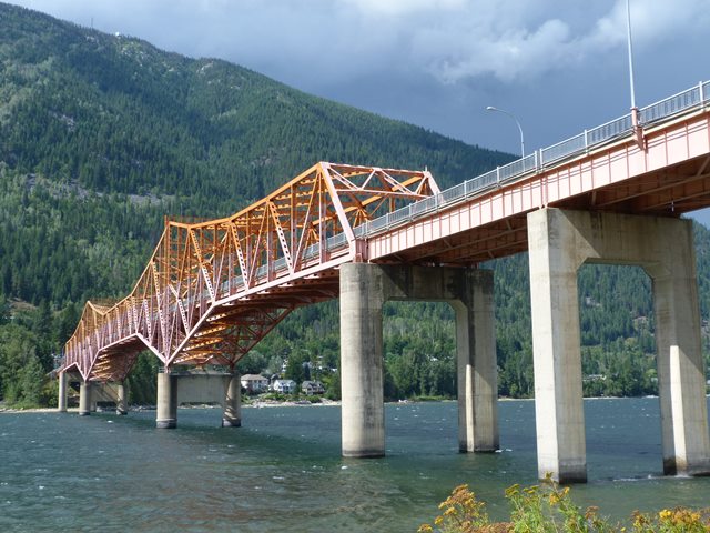
This bridge is the only crossing of the Kootenay River in Nelson, and as a large, iconic bridge, it is a well-known landmark and locally is affectionately known as the Big Orange Bridge, or the BOB for short. It is a traditional cantilever through truss with three spans including a central span consisting of cantilever arms holding a suspended span in the middle. In additional to the top chord which forms towers over the pier points, the bridge also includes a bottom chord which also is angled near the piers so as to form a deeper truss over the piers. The truss includes numerous built-up beams. All shop fasteners (such as those holding the built-up beams together) are rivets, while the fasters installed in the field (like the connection points) are bolted. The bridge includes a system of approach spans that is much longer at the south end and includes deck plate girder spans as well as steel stringer spans. The bridge retains original standard plan ornamental railings for the sidewalks. The sidewalks are located inside the truss lines.
Western Bridge and Steel Fabricators were listed as contractors for the bridge as was Poole Engineering - Raymond International. Originally a toll bridge, it was built by the British Columbia Toll Highways and Bridges Authority. F. T. Brown was listed as Chief Engineer. C. K. Saunders was listed as the bridge engineer. A. B. Sanderson and Company was the consulting engineer for the bridge. Tolls were removed on March 31, 1963.
Premier Bennett Cuts Ribbon to Start Bridge Traffic Rolling
The new West Arm bridge at Nelson was opened Thursday, (Nov.7,) as a beaming Premier Bennett cut a broad green ribbon in front of toll
gates at the southern approach. Hundreds of people stood on the sidelines in the frost-tinged sunshine to watch the ceremonies.
Then the cavalcade carrying the premier, three of his Cabinet ministers, city Council members, private cars ancient and new crawled across the span, led by brightly tartaned pipers and drummers of the Kootenay Kiltie Band.
Highways minister P.A. Gaglardi, who conducted ceremonies from the official platform adjacent to the gates, called the bridge "an imposing and important structure". He said, "The government, without promises and fanfare has recognized the importance of this part of the country by building this bridge." Main speaker Premier W.A.C. Bennett said, "This is a happy and great day for Nelson... for the whole province ... for your MLA (Hon. W.D. Black, provincial secretary) who is ill and for Mr. Gaglardi our amazing highways minister." He then received a pair of scissors from long-time (44 years) cable ferry operator, George Clerihew, and said "I take great pleasure as Premier in cutting this ribbon and declaring this bridge open."
Of the building of the bridge he said, "People at first said it couldn't be done, but we've shown it can, even if it costs a bit. Nobody wants toll bridges, but there's one thing we hate more, and that's no bridge." He then promised that $100,000 a year would go onto the bridge account, combined with the toll revenue to make the bridge free as soon as possible.
Prominent on the opening scene were representatives of the firms involved in design, engineering and construction of the bridge, and local officials. Many district people came out for Nelson's event of the year. Canon W.J. Silverwood dedicated the bridge "in the spirit of thanks- giving to the peace and glory of all mankind," and Mayor Joseph Kary expressed citizens' pride in their new $4,000,000 bridge. Even before the cavalcade moved across the span, pedestrians swarmed over the bridge, Vehicles, some of them held up by the hour-long proceeding, others waiting to be among the first to cross, lined Nelson Avenue and intersecting streets for blocks.
![]()
![]()
![]()
Coordinates (Latitude, Longitude):
Search For Additional Bridge Listings:
Additional Maps:
Google Streetview (If Available)
GeoHack (Additional Links and Coordinates)
Apple Maps (Via DuckDuckGo Search)
Apple Maps (Apple devices only)
Android: Open Location In Your Map or GPS App
Flickr Gallery (Find Nearby Photos)
Wikimedia Commons (Find Nearby Photos)
Directions Via Sygic For Android
Directions Via Sygic For iOS and Android Dolphin Browser

© Copyright 2003-2024, HistoricBridges.org. All Rights Reserved. Disclaimer: HistoricBridges.org is a volunteer group of private citizens. HistoricBridges.org is NOT a government agency, does not represent or work with any governmental agencies, nor is it in any way associated with any government agency or any non-profit organization. While we strive for accuracy in our factual content, HistoricBridges.org offers no guarantee of accuracy. Information is provided "as is" without warranty of any kind, either expressed or implied. Information could include technical inaccuracies or errors of omission. Opinions and commentary are the opinions of the respective HistoricBridges.org member who made them and do not necessarily represent the views of anyone else, including any outside photographers whose images may appear on the page in which the commentary appears. HistoricBridges.org does not bear any responsibility for any consequences resulting from the use of this or any other HistoricBridges.org information. Owners and users of bridges have the responsibility of correctly following all applicable laws, rules, and regulations, regardless of any HistoricBridges.org information.
![]()