

View Information About HSR Ratings
Canada has a wealth of beautiful bridges with heritage value, however due to the lack of a national bridge inventory in the country, as well as limited coverage from other bridge-related websites, these treasures are largely unknown to the world. Unfortunately, much of the large country of Canada is beyond the HistoricBridges.org team's current area of coverage as dictated by limitations in time and funding. As such, this bridge has not yet been photo-documented/inspected by any members of the HistoricBridges.org team. Because of all these facts, in particular the importance of raising awareness of heritage bridges in Canada, HistoricBridges.org has chosen to include a number of Canadian bridges with photos acquired from helpful website contributors, and/or by creating a Public Photograph Compilation. Photos available for Canadian bridges offered through these methods may offer an incomplete photo-documentation, lacking sufficient overview and/or detail photos, however it is hoped that the photos and narratives offered will still be of benefit.
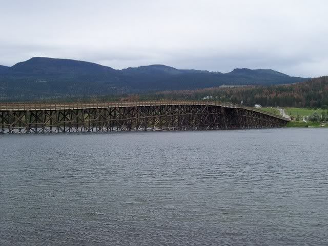
This bridge is a rather long highway wooden stringer bridge that was apparently built in the early 1900s. Its visual form is that of a bridge which slowly rises in height to the center of the bridge to allow sufficient clearance for any boats that may traverse the river. The bridge is situated on a complex system of wooden bents that support short wooden spans. This pattern is broken only at the center where a longer channel span is present. Despite its length, the bridge is a narrow one-lane bridge. There are wider pull-off sections on the bridge where traffic can pull over and wait for oncoming traffic to pass. The deck is concrete and capable of handling fully loaded logging trucks. The other primary function of the bridge is to provide access to a residential area on the north side of the river.
![]()
![]()
![]()
Coordinates (Latitude, Longitude):
Search For Additional Bridge Listings:
Additional Maps:
Google Streetview (If Available)
GeoHack (Additional Links and Coordinates)
Apple Maps (Via DuckDuckGo Search)
Apple Maps (Apple devices only)
Android: Open Location In Your Map or GPS App
Flickr Gallery (Find Nearby Photos)
Wikimedia Commons (Find Nearby Photos)
Directions Via Sygic For Android
Directions Via Sygic For iOS and Android Dolphin Browser

© Copyright 2003-2024, HistoricBridges.org. All Rights Reserved. Disclaimer: HistoricBridges.org is a volunteer group of private citizens. HistoricBridges.org is NOT a government agency, does not represent or work with any governmental agencies, nor is it in any way associated with any government agency or any non-profit organization. While we strive for accuracy in our factual content, HistoricBridges.org offers no guarantee of accuracy. Information is provided "as is" without warranty of any kind, either expressed or implied. Information could include technical inaccuracies or errors of omission. Opinions and commentary are the opinions of the respective HistoricBridges.org member who made them and do not necessarily represent the views of anyone else, including any outside photographers whose images may appear on the page in which the commentary appears. HistoricBridges.org does not bear any responsibility for any consequences resulting from the use of this or any other HistoricBridges.org information. Owners and users of bridges have the responsibility of correctly following all applicable laws, rules, and regulations, regardless of any HistoricBridges.org information.
![]()