

View Information About HSR Ratings

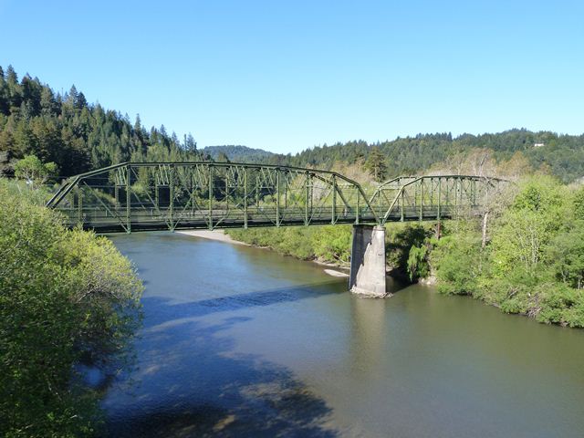
This bridge is an uncommon example of a pin-connected Parker truss, although multiple examples survive on the Russian River. The bridge also is noted for its multi-span configuration, with three main spans. A series of concrete t-beam spans provide an approach to the main spans. The bridge truss configuration is unusual in that with the two center panels of the truss, the diagonal members pass through two panels instead of just one which is the case with the other panels on the truss. The center panels make the bridge look like a Pennsylvania truss, although the other panels do not display this design, which is why the bridge is being classified as a Parker and not a Pennsylvania truss. The truss retains lattice railings. The good news with this bridge is that the bridge was bypassed by a new highway bridge with the historic bridge being preserved in place for pedestrian use. The only problem is someone went a little overkill with adding cyclone fencing to the railing, which is unsightly and obstructs the view of the truss. More attractive railings and barriers are available that can meet safety needs. Otherwise, the bridge appears to retain good historic integrity and is a good example of historic bridge preservation.
![]()
![]()
![]()
Coordinates (Latitude, Longitude):
Search For Additional Bridge Listings:
Bridgehunter.com: View listed bridges within 0.5 miles (0.8 kilometers) of this bridge.
Bridgehunter.com: View listed bridges within 10 miles (16 kilometers) of this bridge.
Additional Maps:
Google Streetview (If Available)
GeoHack (Additional Links and Coordinates)
Apple Maps (Via DuckDuckGo Search)
Apple Maps (Apple devices only)
Android: Open Location In Your Map or GPS App
Flickr Gallery (Find Nearby Photos)
Wikimedia Commons (Find Nearby Photos)
Directions Via Sygic For Android
Directions Via Sygic For iOS and Android Dolphin Browser
USGS National Map (United States Only)
Historical USGS Topo Maps (United States Only)
Historic Aerials (United States Only)
CalTopo Maps (United States Only)

© Copyright 2003-2024, HistoricBridges.org. All Rights Reserved. Disclaimer: HistoricBridges.org is a volunteer group of private citizens. HistoricBridges.org is NOT a government agency, does not represent or work with any governmental agencies, nor is it in any way associated with any government agency or any non-profit organization. While we strive for accuracy in our factual content, HistoricBridges.org offers no guarantee of accuracy. Information is provided "as is" without warranty of any kind, either expressed or implied. Information could include technical inaccuracies or errors of omission. Opinions and commentary are the opinions of the respective HistoricBridges.org member who made them and do not necessarily represent the views of anyone else, including any outside photographers whose images may appear on the page in which the commentary appears. HistoricBridges.org does not bear any responsibility for any consequences resulting from the use of this or any other HistoricBridges.org information. Owners and users of bridges have the responsibility of correctly following all applicable laws, rules, and regulations, regardless of any HistoricBridges.org information.
![]()