

View Information About HSR Ratings
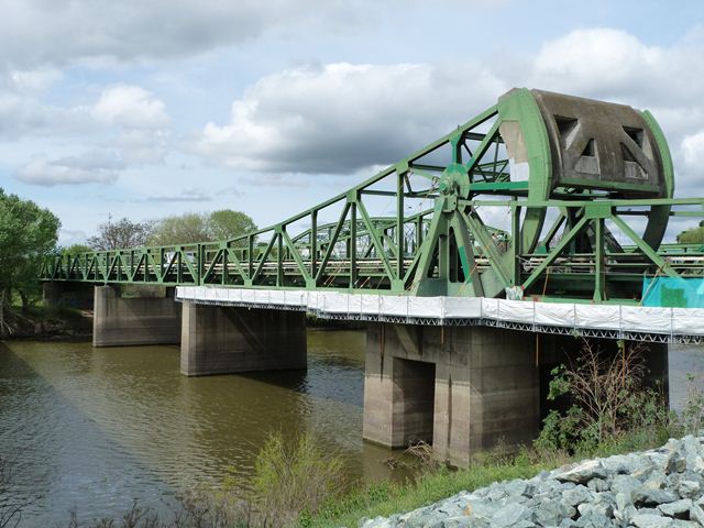
While not an early example of the technology, this bridge has some unusual aspects that make it noteworthy. The bridge is a common type of bascule, the fixed trunnion, but it is unusual because it has an overhead counterweight and trunnion. With fixed trunnion bascules, most commonly the counterweight was located below the deck in a counterweight pit, and the trunnion would also be located below the deck. With the trunnion clearly visible above the roadway, and the massive counterweight hard to ignore, the bridge is a very visual display how a fixed trunnion bascule works, even though it no longer operates for boats. The approach pony truss spans of this bridge are also noteworthy because they are continuous. The concrete counterweight was carefully designed to visually merge with the trusses rather that sticking out like on many bascule bridges. To help reduce the size of the counterweight, heavy magnetite aggregate was used in the concrete to maximize the weight.
This area has a long history of bridge crossings. In 1869 the Transcontinental Railroad was extended from Sacramento to Oakland, passing through here.
![]()
![]()
![]()
Coordinates (Latitude, Longitude):
Search For Additional Bridge Listings:
Bridgehunter.com: View listed bridges within 0.5 miles (0.8 kilometers) of this bridge.
Bridgehunter.com: View listed bridges within 10 miles (16 kilometers) of this bridge.
Additional Maps:
Google Streetview (If Available)
GeoHack (Additional Links and Coordinates)
Apple Maps (Via DuckDuckGo Search)
Apple Maps (Apple devices only)
Android: Open Location In Your Map or GPS App
Flickr Gallery (Find Nearby Photos)
Wikimedia Commons (Find Nearby Photos)
Directions Via Sygic For Android
Directions Via Sygic For iOS and Android Dolphin Browser
USGS National Map (United States Only)
Historical USGS Topo Maps (United States Only)
Historic Aerials (United States Only)
CalTopo Maps (United States Only)

© Copyright 2003-2024, HistoricBridges.org. All Rights Reserved. Disclaimer: HistoricBridges.org is a volunteer group of private citizens. HistoricBridges.org is NOT a government agency, does not represent or work with any governmental agencies, nor is it in any way associated with any government agency or any non-profit organization. While we strive for accuracy in our factual content, HistoricBridges.org offers no guarantee of accuracy. Information is provided "as is" without warranty of any kind, either expressed or implied. Information could include technical inaccuracies or errors of omission. Opinions and commentary are the opinions of the respective HistoricBridges.org member who made them and do not necessarily represent the views of anyone else, including any outside photographers whose images may appear on the page in which the commentary appears. HistoricBridges.org does not bear any responsibility for any consequences resulting from the use of this or any other HistoricBridges.org information. Owners and users of bridges have the responsibility of correctly following all applicable laws, rules, and regulations, regardless of any HistoricBridges.org information.
![]()