We Recommend:
Bach Steel - Experts at historic truss bridge restoration.
I Street Bridge

Primary Photographer(s): Nathan Holth
Bridge Documented: April 5, 2013
I Street and Railroad (Southern Pacific) Over Sacramento River
Sacramento and West Sacramento: Sacramento County, California and Yolo County, California: United States
Metal Rivet-Connected Baltimore Through Truss, Movable: Swing (Center Bearing Center Pier) and Approach Spans: Metal Rivet-Connected Baltimore Deck Truss, Fixed
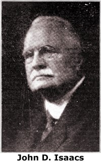
1911 By Builder/Contractor: American Bridge Company of New York, New York and Engineer/Design: John D. Isaacs
1959
195.0 Feet (59.4 Meters)
854.0 Feet (260.3 Meters)
18 Feet (5.49 Meters)
1 Main Span(s) and 3 Approach Span(s)
22C0153

View Information About HSR Ratings
Bridge Documentation
This bridge's future is at risk!
Bridge Status: The Future of This Historic Bridge Is Uncertain And Demolition Is A Possibility!View Archived National Bridge Inventory Report - Has Additional Details and Evaluation
View Historical Biography of Engineer John D. Isaacs
View National Register of Historic Places Nomination Form For This Historic Bridge
View Historic Bridge Inventory Sheet For This Bridge
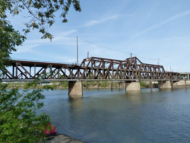
This bridge is a very rare example of a double-deck swing bridge. The bridge is also the oldest of the remaining swing bridges on California highways. The lower deck carries railroad traffic and the upper deck carries vehicular traffic. The "I Street Bridge" proper contains three fixed deck truss spans and a through truss swing bridge. This bridge's length and dimensions are included in the Technical Facts table above. However, for vehicular traffic, the overall bridge also includes from the west a curved approach system dating to 1959 and to the east, there are two approach ramps, an interesting ramp bridge on Jibboom Street dating to 1937, which intersects the approach at a 90 degree angle, and also a straight-on approach leading east away from the bridge.
Aside from the newer nature of the approach spans, the truss spans themselves retain good historic integrity with no major alterations. In terms of design style and appearance, this combined highway and railroad bridge has the appearance of a railroad bridge. The bridge was actually designed by John D. Isaacs for the Southern Pacific Railroad. The American Bridge Company of New York, New York constructed the superstructure, with the Missouri Valley Bridge and Iron Company of Leavenworth, Kansas constructing the substructure.
In 2013, an announcement was made that federal funding assistance was approved for the replacement of this historic bridge which is listed on the National Register of Historic Places with a new vehicular bridge. This will require a Section 106 Review to consider alternatives to demolition of the historic bridge. HistoricBridges.org looks forward to a broad, detailed consideration of numerous alternatives that are available to avoid or minimize adverse effect to the historic bridge. Demolition of this highly rare bridge (which remains in good structural condition despite the poor condition of the paint system) is something that appears to be avoidable, even if it means leaving the historic bridge standing for pedestrian use next to a replacement bridge.
![]()
Photo Galleries and Videos: I Street Bridge
Bridge Photo-Documentation
Original / Full Size PhotosA collection of overview and detail photos. This gallery offers photos in the highest available resolution and file size in a touch-friendly popup viewer.
Alternatively, Browse Without Using Viewer
![]()
Bridge Photo-Documentation
Mobile Optimized PhotosA collection of overview and detail photos. This gallery features data-friendly, fast-loading photos in a touch-friendly popup viewer.
Alternatively, Browse Without Using Viewer
![]()
CarCam: Westbound Crossing
Full Motion VideoThe video includes the approach to the bridge via Jiboom Street. Note: The downloadable high quality version of this video (available on the video page) is well worth the download since it offers excellent 1080 HD detail and is vastly more impressive than the compressed streaming video. Streaming video of the bridge. Also includes a higher quality downloadable video for greater clarity or offline viewing.
![]()
Maps and Links: I Street Bridge
Coordinates (Latitude, Longitude):
Search For Additional Bridge Listings:
Bridgehunter.com: View listed bridges within 0.5 miles (0.8 kilometers) of this bridge.
Bridgehunter.com: View listed bridges within 10 miles (16 kilometers) of this bridge.
Additional Maps:
Google Streetview (If Available)
GeoHack (Additional Links and Coordinates)
Apple Maps (Via DuckDuckGo Search)
Apple Maps (Apple devices only)
Android: Open Location In Your Map or GPS App
Flickr Gallery (Find Nearby Photos)
Wikimedia Commons (Find Nearby Photos)
Directions Via Sygic For Android
Directions Via Sygic For iOS and Android Dolphin Browser
USGS National Map (United States Only)
Historical USGS Topo Maps (United States Only)
Historic Aerials (United States Only)
CalTopo Maps (United States Only)


