We Recommend:
Bach Steel - Experts at historic truss bridge restoration.
BridgeHunter.com Phase 1 is released to the public! - Visit Now
Cleveland Street Bridge

Primary Photographer(s): Nathan Holth
Bridge Documented: March 6, 2006 and March 25, 2010
Ionia: Ionia County, Michigan: United States
1931 By Builder/Contractor: Lovering-Longbotham Company and Engineer/Design: Michigan State Highway Department
Not Available or Not Applicable
74.8 Feet (22.8 Meters)
375.0 Feet (114.3 Meters)
30 Feet (9.14 Meters)
5 Main Span(s)
34200065000B010

View Information About HSR Ratings
Bridge Documentation
This bridge no longer exists!
Ionia County Road Commission Demolished And Replaced This Historic Bridge In May 2013!
About The Bridge
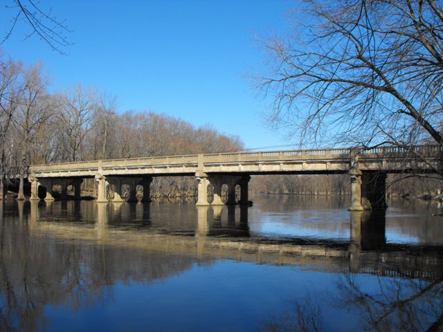
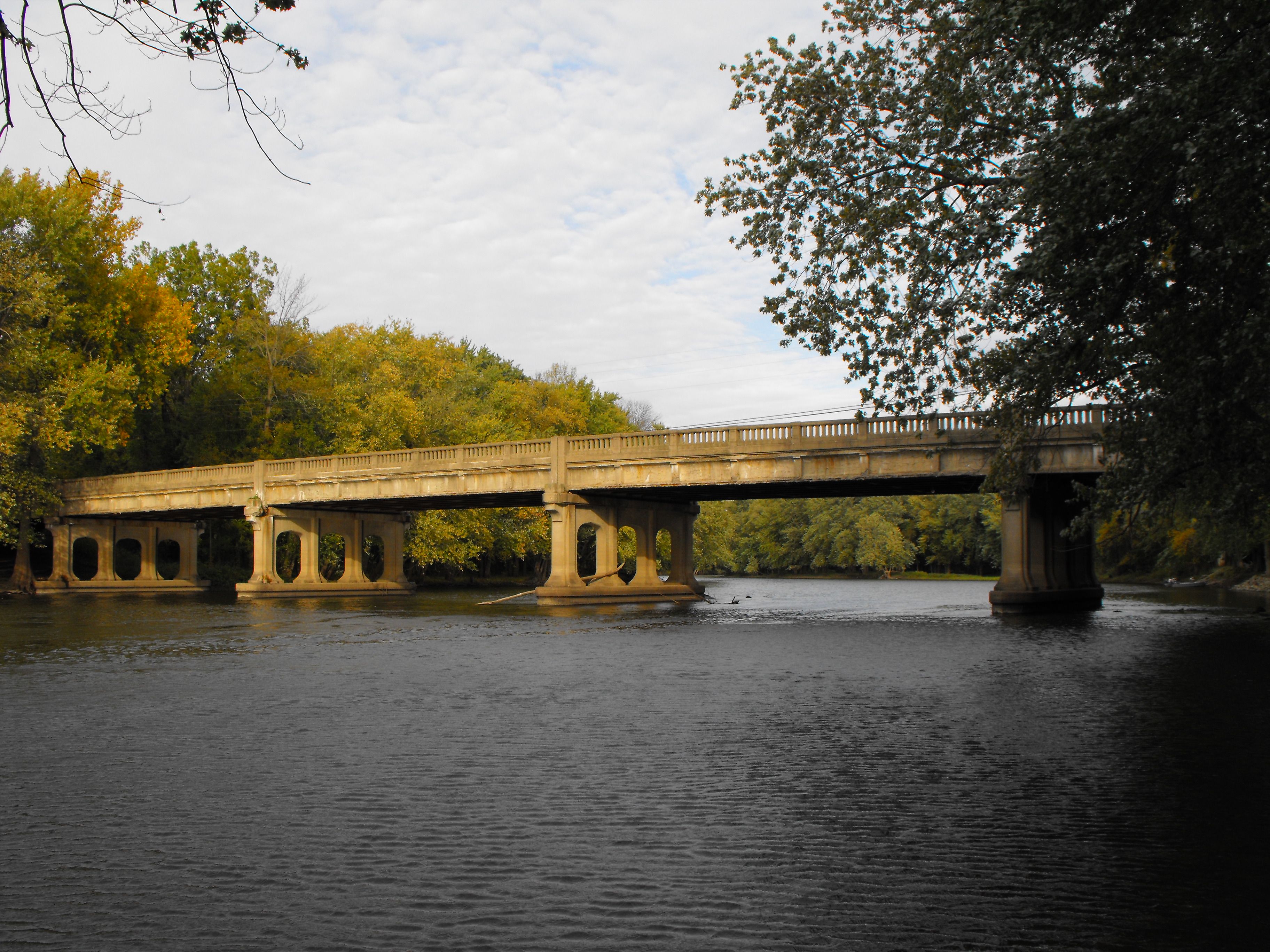
This bridge, which is posted for a 49 ton weight limit, is five spans in length, and was built by contractor Lovering and Longbotham Company according the the plaque on the bridge. The bridge's stringers are large, riveted built-up i-beams. Plaques identified this bridge as a "Trunk Line Bridge" built in 1931. A visit to MichiganHighways.org clears up any confusion. It turns out that M-21 used to be Riverside Drive and ran south of the Grand River, rather than Bluewater Highway north of the river. The transition from the south side to the north side was gradually done over a period of years. Obviously, this means that at some point during this time M-21 would have to cross the river to connect the south to the north. This bridge appears to have been built at a time when this split was in progress. This bridge was likely a Trunk Line Bridge only for a little while.
The concrete piers for this Cleveland Street Bridge are quite detailed, moreso than in the majority of other examples of this standard plan bridge type. This standard plan bridge type was built in Michigan in large numbers during a relatively small window of approximately 1927 to 1932. The bridge standard was a steel stringer bridge that was noted for its decorative concrete facade on the outermost stringer faces, and the decorative balustrade railings. To a casual viewer, the bridge appears to be an all-concrete bridge. This particular bridge's railing have interesting design where they are separated at each pier. This bridge also has the slightest camber in its deck.
The combination of the decorative piers, decorative concrete facade on the outermost stringer faces, and the decorative balustrade railings make this bridge among the most beautiful steel stringer bridges in Michigan. The design of this bridge takes a relatively simple and mundane structure type and transforms it into a work of art.
In 2013, this bridge was demolished and replaced. One of the workers who was on the construction site during the demolition discovered that the bridge was built upon timber piles, and he saved some of the timbers and had them cut into boards for reuse. The cut timbers had a light, grey color. It is not known what type of wood they were made out of. A review of the famous 1916 book Bridge Engineering by J.A.L. Waddell did list some of the types of timber used in bridge work. For general bridge work, he listed Douglas fir of the Pacific Coast and long-leaf yellow pine of the southern states. For timber piles, Waddell lists short-leaf yellow pine, cypress (red, black, and yellow), and Pacific Coast cedar as good timber for piling.
HistoricBridges.org Comments Produced Prior To Demolition
This bridge is currently considered ineligible for listing in the National Register of Historic Places, however a re-evaluation of eligibility needs to be considered because that assessment is now outdated and incorrectly reflects the importance of the bridge today. The Cleveland Street Bridge is similar to the demolished Center Road Bridge in terms of general design, railing, and span numbers, but with more ornate pier design, and with longer spans and total length. The Center Road Bridge was assessed as eligible for listing in the National Register of Historic Places, because it was a good representative example of a late 1920s stringer bridge with long spans, and reflected advances in steel mill and bridge building capabilities. There were also some other similar late 1920s bridges found eligible for listing in the National Register under similar findings, including the US-2 Bridge over Sturgeon River in Dickenson County, and the State Park Drive Bridge over Kawkawlin River in Bay County. Both of these bridges have since been demolished. All of these large multi-span stringer bridges from the late 1920s appear to have been demolished. As a result, the Cleveland Street Bridge, built in the 1931 is the next best example of this development in bridge construction. Therefore, it should be re-evaluated as eligible for listing in the National Register of Historic Places.
Ionia County plans to demolish and replace this historic bridge. This is a very disappointing decision that HistoricBridges.org urges Ionia County to reconsider, because the existing bridge's design appears to be appropriate for the conditions of the road it serves, and it appears that rehabilitation is not only feasible, but it might also be more fiscally responsible as well, to say nothing of the value of preserving a bridge that has both historic and aesthetic value. Further, the bridge is not on an extremely important road. The bridge appears to carry mostly local traffic. A modern bridge on M-66, a major highway, is a mile west of this bridge which is what most through traffic and heavy truck traffic appears to use.
The 2009 National Bridge Inventory evaluations for the bridge were Superstructure: Fair (5/10) Substructure: Fair (5/10) Deck: Poor (4/10). For a bridge which is nearly 80 years old, has never had a comprehensive rehabilitation in its entire life, this condition is actually very good and is indicative of a bridge for which rehabilitation is feasible and may well cost less to rehabilitate than to replace. It is not indicative of a bridge which is beyond repair and for which replacement is the best choice.
The bridge presents a unique opportunity for preservation. Unlike many historic bridges which are often very narrow when compared with the modern needs of the roadways they serve, this bridge has generous shoulders that are actually quite wide when compared with the approaching roadway. There are also narrow sidewalks on the bridge. The width of the bridge is such that a couple of deck alterations would be possible if changes were determined to be needed. If a more modern sidewalk was needed, the two modern sidewalks could be combined to form a wider sidewalk. Alternatively, the sidewalks could also be eliminated to increase the shoulder size as well. There also would be room for the installation of Michigan's "two-tube" guardrails in between the edges of the roadway and the existing historic balustrade railings. The two-tube guardrails are low-profile railings that are not visually obstructive, yet also provide AASHTO approved crash-tested protection. Clearly, the wide deck means that there are options with this bridge. However, any reconfiguration of the deck should not remove the original concrete balustrade railings.
![]()
Photo Galleries and Videos: Cleveland Street Bridge
2010 Bridge Photo-Documentation
Original / Full Size PhotosA collection of overview and detail photos. Taken on a beautiful, sunny day. This gallery offers photos in the highest available resolution and file size in a touch-friendly popup viewer.
Alternatively, Browse Without Using Viewer
![]()
2010 Bridge Photo-Documentation
Mobile Optimized PhotosA collection of overview and detail photos. Taken on a beautiful, sunny day. This gallery features data-friendly, fast-loading photos in a touch-friendly popup viewer.
Alternatively, Browse Without Using Viewer
![]()
Additional Bridge Photo-Documentation
A collection of overview and detail photos from before 2010. Includes photos of the plaque and balustrade railing details. This photo gallery contains a combination of Original Size photos and Mobile Optimized photos in a touch-friendly popup viewer.Alternatively, Browse Without Using Viewer
![]()
Maps and Links: Cleveland Street Bridge
This historic bridge has been demolished. This map is shown for reference purposes only.
Coordinates (Latitude, Longitude):
Search For Additional Bridge Listings:
Bridgehunter.com: View listed bridges within 0.5 miles (0.8 kilometers) of this bridge.
Bridgehunter.com: View listed bridges within 10 miles (16 kilometers) of this bridge.
Additional Maps:
Google Streetview (If Available)
GeoHack (Additional Links and Coordinates)
Apple Maps (Via DuckDuckGo Search)
Apple Maps (Apple devices only)
Android: Open Location In Your Map or GPS App
Flickr Gallery (Find Nearby Photos)
Wikimedia Commons (Find Nearby Photos)
Directions Via Sygic For Android
Directions Via Sygic For iOS and Android Dolphin Browser
USGS National Map (United States Only)
Historical USGS Topo Maps (United States Only)
Historic Aerials (United States Only)
CalTopo Maps (United States Only)


