We Recommend:
Bach Steel - Experts at historic truss bridge restoration.
BridgeHunter.com Phase 1 is released to the public! - Visit Now
Bridge Street Bridge
Elkhart County Bridge 387

Primary Photographer(s): Nathan Holth
Bridge Documented: Fall 2005 and Spring 2012
Elkhart: Elkhart County, Indiana: United States
2009
116.8 Feet (35.6 Meters)
274.0 Feet (83.5 Meters)
39.4 Feet (12.01 Meters)
3 Main Span(s)
2000165

View Information About HSR Ratings
Bridge Documentation
View Archived National Bridge Inventory Report - Has Additional Details and Evaluation
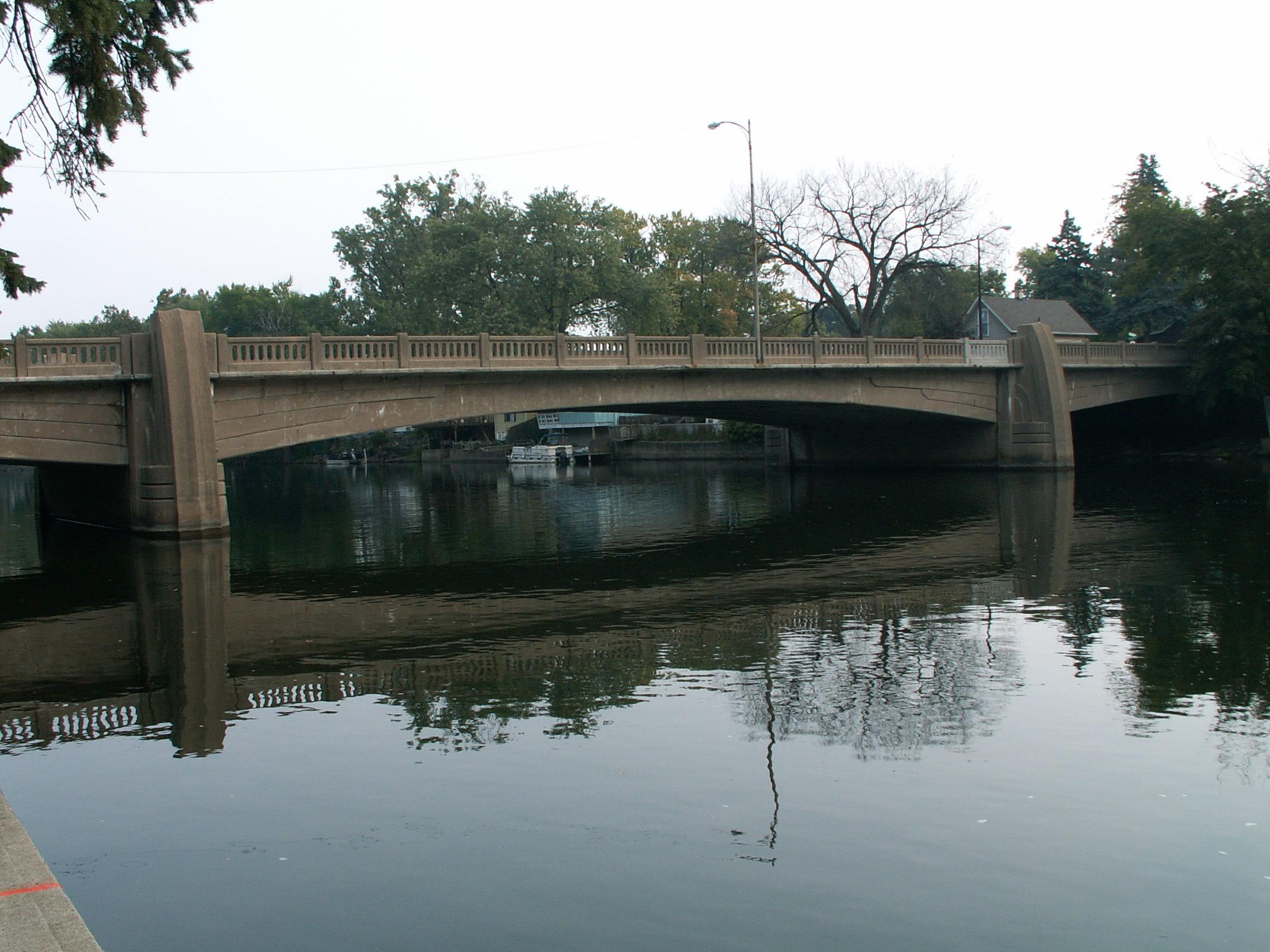
This is an unusual bridge as it is a curved t-beam bridge. The arches feature decorative treatment as do the piers on the bridge which extend above the guardrails of the bridge. With the large concrete piers and the shallow arch at the central span, it is not hard to imagine that if a double-leaf plate girder bascule bridge were magically turned to concrete, this is what it might look like!
This bridge was built in 1939. The contractor for the bridge was H. L. Maddocks Co. The bridge was built through Depression relief programs which increases the bridge's historic significance.
Information and Findings From DHPA Historic Bridge SurveyStatement of Significance This is one of the earliest and widest continuous reinforced concrete T-beam structures built in Indiana, and it carries the longest span of its kind constructed before the Second World War. A prolific regional Hoosier engineer designed and decorated it for an urban setting. The bridge retains its architectural and structural integrity. Architectural Description As Indiana was recovering from the worst of the
Greet Depression just before the Second World War, its counties began to
resume some bridge-building, here with the assistance of the Public
Works Administration of the Federal Works Agency. In a couple of cases,
local officals agreed for the first time to plans for crossing major
waterways with continuous reinforced concrete T-beams because of their
advertised economy. By constructing the beams of multiple spans as a
unit, the beams in one span get help carrying a load from their
extension over others, allowing for shallower beams and slimmer piers.
To carry the tension generated in the flanges of continuous beams over
piers, designers typically add reinforcing steel towards the top of the
beams. Bridge Considered Historic By Survey: Yes |
![]()
Photo Galleries and Videos: Bridge Street Bridge
2012 Bridge Photo-Documentation
Original / Full Size PhotosA collection of overview and detail photos taken after the bridge was rehabilitated in 2009. This gallery offers photos in the highest available resolution and file size in a touch-friendly popup viewer.
Alternatively, Browse Without Using Viewer
![]()
2012 Bridge Photo-Documentation
Mobile Optimized PhotosA collection of overview and detail photos taken after the bridge was rehabilitated in 2009. This gallery features data-friendly, fast-loading photos in a touch-friendly popup viewer.
Alternatively, Browse Without Using Viewer
![]()
Pre-Rehab Bridge Photo-Documentation
A collection of overview and detail photos taken before the bridge rehabilitation in 2009. This photo gallery contains a combination of Original Size photos and Mobile Optimized photos in a touch-friendly popup viewer.Alternatively, Browse Without Using Viewer
![]()
Maps and Links: Bridge Street Bridge
Coordinates (Latitude, Longitude):
Search For Additional Bridge Listings:
Bridgehunter.com: View listed bridges within 0.5 miles (0.8 kilometers) of this bridge.
Bridgehunter.com: View listed bridges within 10 miles (16 kilometers) of this bridge.
Additional Maps:
Google Streetview (If Available)
GeoHack (Additional Links and Coordinates)
Apple Maps (Via DuckDuckGo Search)
Apple Maps (Apple devices only)
Android: Open Location In Your Map or GPS App
Flickr Gallery (Find Nearby Photos)
Wikimedia Commons (Find Nearby Photos)
Directions Via Sygic For Android
Directions Via Sygic For iOS and Android Dolphin Browser
USGS National Map (United States Only)
Historical USGS Topo Maps (United States Only)
Historic Aerials (United States Only)
CalTopo Maps (United States Only)


