

View Information About HSR Ratings
Another similar, but shorter bridge is down the road, in much better condition than this bridge, the Fisher Road Birch Creek Bridge.
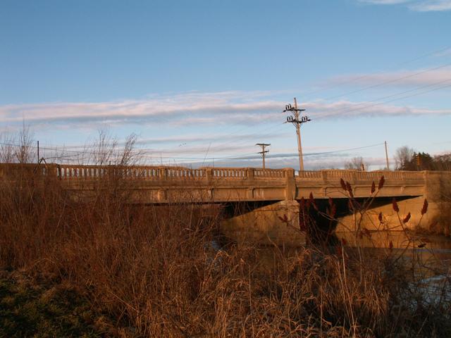
If one were to feel sorry for a bridge, surely this would be the one to feel sorry for. There are two gravel pits: one on each side of this bridge, and there are constantly trucks and bulldozers going back and forth between the two pits. These trucks are often carrying stone that is wet, and they drip water on the bridge all the time, which most likely has led to the severe deterioration of the railings. The railings had spalled to the point where entire parts of the railing were missing. On the other hand, enough of the railings remained that the bridge still had an attractive historic look to it, especially when the bridge was viewed from beside the river banks.
Despite the condition of the railings on the bridge, the steel stringers under the bridge are in excellent condition, and capable of supporting the heavy trucks. Indeed, the road commission was even surprised at the good condition of the stringers and they decided to redo the deck of this bridge in summer 2007. They initially left the railings alone. This would have been a great time to repair the original railings, or even rebuild them completely, replicating the original design, as was done on the M-65 abutments. However, the St. Clair County Road Commission, with a knack for making bad things worse, simply added modern Armco guardrails and completely removed the original railings. Adding the modern guardrails is distasteful, but it this has been done to a lot of historic bridges and at least it does not destroy the originals. In St. Clair County, the Belle River Bridge is a good example. The real issue is why did the county destroy the original railings? Removing them was a waste of money and it served no purpose. One might think that if the original railings were removed, the new railings would be placed where the old ones were to maintain a decent deck width, but St. Clair County didn't even do that, simply placing the modern Armco guardrails in front of where the original railings were, and then cutting the original railings off. All this did was create a dangerous, unprotected ledge for kids and fishers to wander out onto. In addition, all motorists notice is an uglier bridge that feels a lot more narrow.
The HSR rating for this bridge regards the significance of this bridge prior to alteration. The bridge today has no significant historic value.
![]()
![]()
![]()
![]()
This historic bridge has been demolished. This map is shown for reference purposes only.
Coordinates (Latitude, Longitude):
Search For Additional Bridge Listings:
Bridgehunter.com: View listed bridges within 0.5 miles (0.8 kilometers) of this bridge.
Bridgehunter.com: View listed bridges within 10 miles (16 kilometers) of this bridge.
Additional Maps:
Google Streetview (If Available)
GeoHack (Additional Links and Coordinates)
Apple Maps (Via DuckDuckGo Search)
Apple Maps (Apple devices only)
Android: Open Location In Your Map or GPS App
Flickr Gallery (Find Nearby Photos)
Wikimedia Commons (Find Nearby Photos)
Directions Via Sygic For Android
Directions Via Sygic For iOS and Android Dolphin Browser
USGS National Map (United States Only)
Historical USGS Topo Maps (United States Only)
Historic Aerials (United States Only)
CalTopo Maps (United States Only)

© Copyright 2003-2025, HistoricBridges.org. All Rights Reserved. Disclaimer: HistoricBridges.org is a volunteer group of private citizens. HistoricBridges.org is NOT a government agency, does not represent or work with any governmental agencies, nor is it in any way associated with any government agency or any non-profit organization. While we strive for accuracy in our factual content, HistoricBridges.org offers no guarantee of accuracy. Information is provided "as is" without warranty of any kind, either expressed or implied. Information could include technical inaccuracies or errors of omission. Opinions and commentary are the opinions of the respective HistoricBridges.org member who made them and do not necessarily represent the views of anyone else, including any outside photographers whose images may appear on the page in which the commentary appears. HistoricBridges.org does not bear any responsibility for any consequences resulting from the use of this or any other HistoricBridges.org information. Owners and users of bridges have the responsibility of correctly following all applicable laws, rules, and regulations, regardless of any HistoricBridges.org information.
![]()