

View Information About HSR Ratings
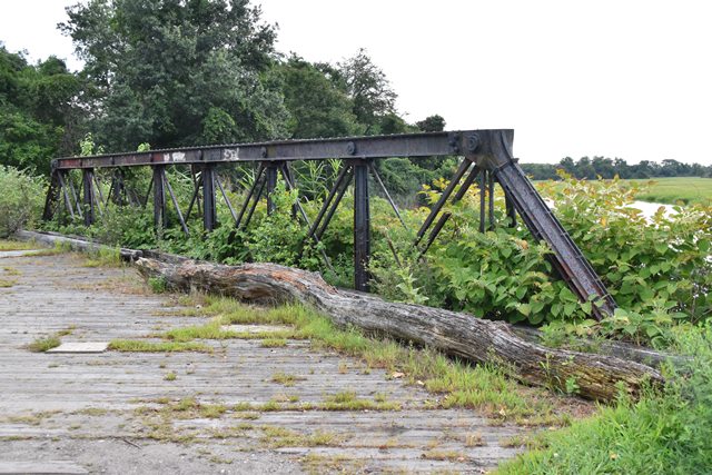
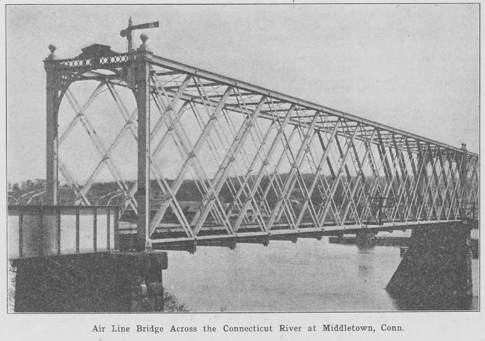
This is an exceedingly rare Keystone column pony truss bridge, and it has been preserved on a trail. It only appears to "cross" pine creek figuratively. The crossing is unusual because the creek appears to be funneled into a series of culverts immediately south of the bridge, while the bridge today rests on what could be described as an earthen causeway. This arrangement has led to a situation where plant life has grown around the bridge and is starting the bury the trusses. For the sake of better bridge viewing and limiting moisture buildup on the trusses, it is suggested that the vegetation be cleared away from the bridge. This bridge reportedly was originally part of an approach to an 1872 movable bridge in Middletown, Connecticut, reused in 1890 to carry Mill Hill Road in Fairfield over the tracks of the New Haven Railroad. In 1979, the bridge was relocated to its current location. As such, the bridge may have come from the bridge shown below, although none of the historical photos actually show the approach spans, so this is only speculation. The below bridge was built by the Keystone Bridge Company in 1872 and was located in Middletown and carried the New York, New Haven and Hartford Railroad. It was partially destroyed by steamboat collision in 1876 and replaced in 1886.

This bridge is tagged with the following special condition(s): Keystone Columns
![]()
![]()
![]()
Coordinates (Latitude, Longitude):
Search For Additional Bridge Listings:
Bridgehunter.com: View listed bridges within 0.5 miles (0.8 kilometers) of this bridge.
Bridgehunter.com: View listed bridges within 10 miles (16 kilometers) of this bridge.
Additional Maps:
Google Streetview (If Available)
GeoHack (Additional Links and Coordinates)
Apple Maps (Via DuckDuckGo Search)
Apple Maps (Apple devices only)
Android: Open Location In Your Map or GPS App
Flickr Gallery (Find Nearby Photos)
Wikimedia Commons (Find Nearby Photos)
Directions Via Sygic For Android
Directions Via Sygic For iOS and Android Dolphin Browser
USGS National Map (United States Only)
Historical USGS Topo Maps (United States Only)
Historic Aerials (United States Only)
CalTopo Maps (United States Only)

© Copyright 2003-2024, HistoricBridges.org. All Rights Reserved. Disclaimer: HistoricBridges.org is a volunteer group of private citizens. HistoricBridges.org is NOT a government agency, does not represent or work with any governmental agencies, nor is it in any way associated with any government agency or any non-profit organization. While we strive for accuracy in our factual content, HistoricBridges.org offers no guarantee of accuracy. Information is provided "as is" without warranty of any kind, either expressed or implied. Information could include technical inaccuracies or errors of omission. Opinions and commentary are the opinions of the respective HistoricBridges.org member who made them and do not necessarily represent the views of anyone else, including any outside photographers whose images may appear on the page in which the commentary appears. HistoricBridges.org does not bear any responsibility for any consequences resulting from the use of this or any other HistoricBridges.org information. Owners and users of bridges have the responsibility of correctly following all applicable laws, rules, and regulations, regardless of any HistoricBridges.org information.
![]()