

View Information About HSR Ratings
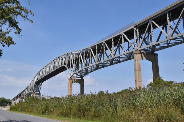
The Chesapeake and Delaware Canal, like many canals that still function today, has a long history. It originally went through Delaware City until that section was realigned in the mid-1920s and a vertical lift bridge was constructed in this area. This bridge was replaced by the current high level fixed bridge in 1968. This bridge is a late but noteworthy example of a form of cantilever truss that is carefully designed to eliminate pointy towers at the piers and instead offer an arch-like appearance, consisting of a deck truss span that transitions into a through truss span. This variety of cantilever truss was intended to offer better aesthetic qualities and started to be built in the 1930s. They are less common than other styles of cantilever truss. Typical of late 1960s construction, this bridge used rivets in the shop and bolts for field assembly. Thus the connections are bolted, and the built-up beams are riveted. Also typical of this period, very little v-lacing or lattice is present on built-up members. One simple span deck truss approach span is located at each end of the three span cantilever truss, with the remaining approach spans being deck plate girder and stringer spans.
![]()
![]()
![]()
Coordinates (Latitude, Longitude):
Search For Additional Bridge Listings:
Bridgehunter.com: View listed bridges within 0.5 miles (0.8 kilometers) of this bridge.
Bridgehunter.com: View listed bridges within 10 miles (16 kilometers) of this bridge.
Additional Maps:
Google Streetview (If Available)
GeoHack (Additional Links and Coordinates)
Apple Maps (Via DuckDuckGo Search)
Apple Maps (Apple devices only)
Android: Open Location In Your Map or GPS App
Flickr Gallery (Find Nearby Photos)
Wikimedia Commons (Find Nearby Photos)
Directions Via Sygic For Android
Directions Via Sygic For iOS and Android Dolphin Browser
USGS National Map (United States Only)
Historical USGS Topo Maps (United States Only)
Historic Aerials (United States Only)
CalTopo Maps (United States Only)

© Copyright 2003-2024, HistoricBridges.org. All Rights Reserved. Disclaimer: HistoricBridges.org is a volunteer group of private citizens. HistoricBridges.org is NOT a government agency, does not represent or work with any governmental agencies, nor is it in any way associated with any government agency or any non-profit organization. While we strive for accuracy in our factual content, HistoricBridges.org offers no guarantee of accuracy. Information is provided "as is" without warranty of any kind, either expressed or implied. Information could include technical inaccuracies or errors of omission. Opinions and commentary are the opinions of the respective HistoricBridges.org member who made them and do not necessarily represent the views of anyone else, including any outside photographers whose images may appear on the page in which the commentary appears. HistoricBridges.org does not bear any responsibility for any consequences resulting from the use of this or any other HistoricBridges.org information. Owners and users of bridges have the responsibility of correctly following all applicable laws, rules, and regulations, regardless of any HistoricBridges.org information.
![]()