

View Information About HSR Ratings
Additional Information: A period news article indicated that on September 1962, Northern Imperial Construction Company of Portland reported a delay of 3-4 days after a 120 foot construction tower collapsed with no injuries to workers.
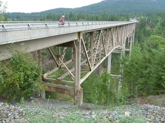
This is a large and extremely high deck truss bridge. It is in fact among the highest in Idaho and beyond with a maximum height of 464 feet or 424 feet (depending on what source you use) as it passes over the Moyie River Canyon. Built in 1965, it was built at the end of the riveting era. It has built-up beams that are not riveted but instead welded... something that makes the bridge look about 10 years newer, more like a 1970s bridge. The connections are bolted. There do appear to be a few rivets on the bracing connections, but that is the extent of rivets on this bridge. Given its late construction date, its historic significance is limited, however its height, length, and continuous configuration combined with the rarity of trusses of any kind in this region give the bridge some level of significance. The bridge is a local attraction because of the views of the canyon that can be seen from the bridge.
The bridge is difficult to photograph and due to time restraints, HistoricBridges.org only has a few photos of this bridge.
![]()
![]()
![]()
Coordinates (Latitude, Longitude):
Search For Additional Bridge Listings:
Bridgehunter.com: View listed bridges within 0.5 miles (0.8 kilometers) of this bridge.
Bridgehunter.com: View listed bridges within 10 miles (16 kilometers) of this bridge.
Additional Maps:
Google Streetview (If Available)
GeoHack (Additional Links and Coordinates)
Apple Maps (Via DuckDuckGo Search)
Apple Maps (Apple devices only)
Android: Open Location In Your Map or GPS App
Flickr Gallery (Find Nearby Photos)
Wikimedia Commons (Find Nearby Photos)
Directions Via Sygic For Android
Directions Via Sygic For iOS and Android Dolphin Browser
USGS National Map (United States Only)
Historical USGS Topo Maps (United States Only)
Historic Aerials (United States Only)
CalTopo Maps (United States Only)

© Copyright 2003-2024, HistoricBridges.org. All Rights Reserved. Disclaimer: HistoricBridges.org is a volunteer group of private citizens. HistoricBridges.org is NOT a government agency, does not represent or work with any governmental agencies, nor is it in any way associated with any government agency or any non-profit organization. While we strive for accuracy in our factual content, HistoricBridges.org offers no guarantee of accuracy. Information is provided "as is" without warranty of any kind, either expressed or implied. Information could include technical inaccuracies or errors of omission. Opinions and commentary are the opinions of the respective HistoricBridges.org member who made them and do not necessarily represent the views of anyone else, including any outside photographers whose images may appear on the page in which the commentary appears. HistoricBridges.org does not bear any responsibility for any consequences resulting from the use of this or any other HistoricBridges.org information. Owners and users of bridges have the responsibility of correctly following all applicable laws, rules, and regulations, regardless of any HistoricBridges.org information.
![]()