

View Information About HSR Ratings
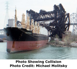
This bridge's leaf was destroyed on May 6, 1988 at 8:08 PM when the Pontokratis, a vessel traveling inland collided with the bridge. The leaf collapsed as a result, falling and wrapping itself around the boat. It caused the Calumet River to close for ten days while the bascule leaf was removed. The fixed approach span and the mechanical frame of the bascule span were not removed and these remain in place today.
Rick La Fever provides the following additional details about how the trains dealt with the loss of this bridge:
This bridge once carried the Baltimore & Ohio Chicago Terminal Railroad(B&OC.T.R.R.) across the Calumet River. The US Coast Guard deemed the bridge unsafe for maritime use (they felt it would fall into the waterway blocking the channel) so it was demolished. The CSX Corp (successor to the B&OC.T.) had other routes around the river so they just rerouted the almost non-existent business to other lines. At the time only the Chicago Short Line Railroad was using the bridge regularly. The CSL now uses the NS bridge to reach some trackage on the west side of the waterway since most of the line is on the east bank of the waterway.

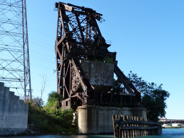
This bridge was historically and technologically significant as an example of a Strauss heel-trunnion bascule bridge. The design and patent for this design was held by the Strauss Bascule Bridge Company, owned by noted engineer Joseph Strauss. For this bridge, another noted engineer, J. E. Greiner also provided design services for this bridge, producing specifications for the bridge. The bridge was noted for having the longest bascule span in the world when completed, although it did not hold that record for very long, as bridges built soon after exceeded the span.
From a historic preservationists standpoint, it is good that the fixed approach span and the mechanical frame of this bascule bridge were not demolished when the leaf was removed. These elements remain in place today both as a visual reminder that a Strauss heel-trunnion bascule bridge was here. The ends of the mechanical frame where the leaf was attached have a twisted appearance, allowing observant viewers to infer that the bridge was destroyed by accident, since a proper demolition would have cut apart the bridge more cleanly.
Be sure to view the photo gallery for this bridge which includes photos of the collision and of the bridge prior to destruction. The links at the top of this narrative include a link to legal proceedings which include a very detailed account of the collision.
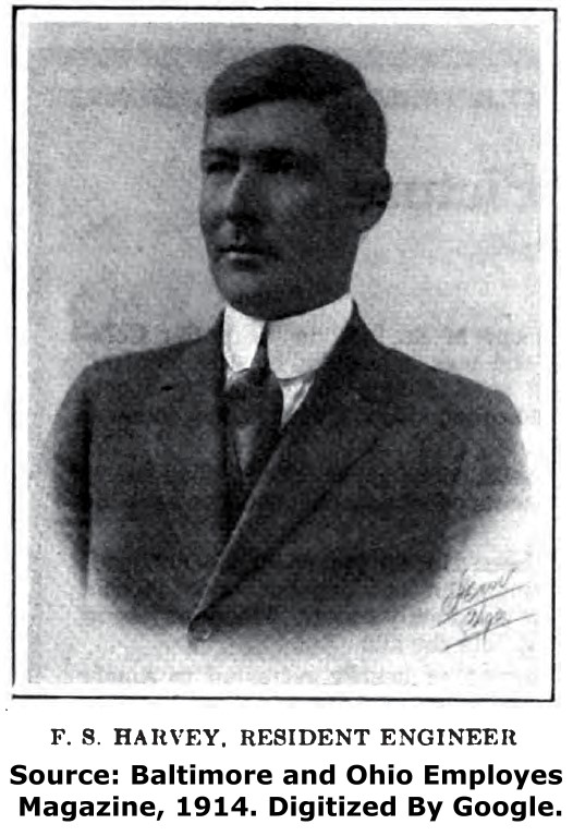
The photos of H. A. Field and F. S Harvey are shown below. These men were in the field as engineer assistants during the construction of the bascule bridge.

![]()
![]()
Complete Bridge List
Chicago and Cook County are home to one of the largest collections of historic bridges in the country, and no other city in the world has more movable bridges. HistoricBridges.org is proud to offer the most extensive coverage of historic Chicago bridges on the Internet.
General Chicago / Cook County Bridge Resources
Additional Online Articles and Resources - This page is a large gathering of interesting articles and resources that HistoricBridges.org has uncovered during research, but which were not specific to a particular bridge listing.
Chicago's Bridges - By Nathan Holth, author of HistoricBridges.org, this book provides a discussion of the history of Chicago's movable bridges, and includes a virtual tour discussing all movable bridges remaining in Chicago today. Despite this broad coverage, the book is presented in a compact format that is easy to take with you and carry around for reference on a visit to Chicago. The book includes dozens of full color photos. Only $9.95 U.S! ($11.95 Canadian). Order on Amazon.
Chicago River Bridges - By Patrick T. McBriarty, this is a great companion to Holth's book shown above. This much larger book offers an extremely in-depth exploration of Chicago's movable highway bridges, including many crossings that have not existed for many years. Order Now Direct From The Publisher! or order on Amazon.
View Historic American Engineering Record (HAER) Overview of Chicago Bascule Bridges (HAER Data Pages, PDF)
Chicago Loop Bridges - Chicago Loop Bridges is another website on the Internet that is a great companion to the HistoricBridges.org coverage of the 18 movable bridges within the Chicago Loop. This website includes additional information such as connections to popular culture, overview discussions and essays about Chicago's movable bridges, additional videos, and current news and events relating to the bridges.
![]()
![]()
![]()
This historic bridge has been demolished. This map is shown for reference purposes only.
Coordinates (Latitude, Longitude):
Search For Additional Bridge Listings:
Bridgehunter.com: View listed bridges within 0.5 miles (0.8 kilometers) of this bridge.
Bridgehunter.com: View listed bridges within 10 miles (16 kilometers) of this bridge.
Additional Maps:
Google Streetview (If Available)
GeoHack (Additional Links and Coordinates)
Apple Maps (Via DuckDuckGo Search)
Apple Maps (Apple devices only)
Android: Open Location In Your Map or GPS App
Flickr Gallery (Find Nearby Photos)
Wikimedia Commons (Find Nearby Photos)
Directions Via Sygic For Android
Directions Via Sygic For iOS and Android Dolphin Browser
USGS National Map (United States Only)
Historical USGS Topo Maps (United States Only)
Historic Aerials (United States Only)
CalTopo Maps (United States Only)

© Copyright 2003-2026, HistoricBridges.org. All Rights Reserved. Disclaimer: HistoricBridges.org is a volunteer group of private citizens. HistoricBridges.org is NOT a government agency, does not represent or work with any governmental agencies, nor is it in any way associated with any government agency or any non-profit organization. While we strive for accuracy in our factual content, HistoricBridges.org offers no guarantee of accuracy. Information is provided "as is" without warranty of any kind, either expressed or implied. Information could include technical inaccuracies or errors of omission. Opinions and commentary are the opinions of the respective HistoricBridges.org member who made them and do not necessarily represent the views of anyone else, including any outside photographers whose images may appear on the page in which the commentary appears. HistoricBridges.org does not bear any responsibility for any consequences resulting from the use of this or any other HistoricBridges.org information. Owners and users of bridges have the responsibility of correctly following all applicable laws, rules, and regulations, regardless of any HistoricBridges.org information.
![]()