We Recommend:
Bach Steel - Experts at historic truss bridge restoration.
BridgeHunter.com Phase 1 is released to the public! - Visit Now
Sugar Creek Chapel Bridge
CR-9 Bridge

Primary Photographer(s): Nathan Holth
Bridge Documented: August 13, 2006 and March 19, 2016
Rural: Iroquois County, Illinois: United States
1904 By Builder/Contractor: P. E. Lane of Chicago, Illinois
Not Available or Not Applicable
159.0 Feet (48.5 Meters)
163.0 Feet (49.7 Meters)
17.4 Feet (5.3 Meters)
1 Main Span(s)
38550008805

View Information About HSR Ratings
Bridge Documentation
View Archived National Bridge Inventory Report - Has Additional Details and Evaluation

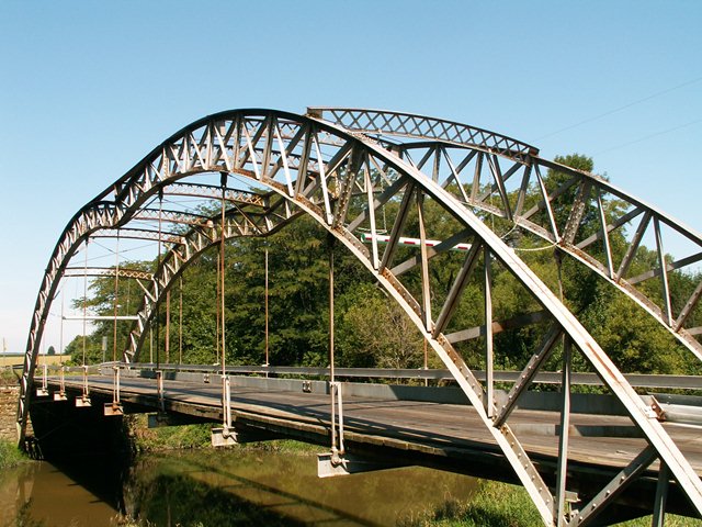
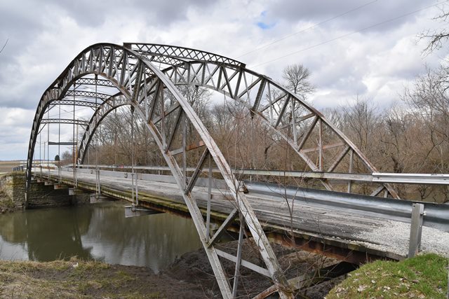
This bridge is a perfect example of what makes historic bridges so fascinating. Not only are historic bridges interesting because they feature old methods of construction and have stood the test of time, they also usually beat modern bridges in terms of unusual design and aesthetic appeal. Modern bridges generally come in two forms. A slab of concrete with no aesthetic design, or a slab of concrete with some bricks, light posts, or other elements added to try (unsuccessfully) to make it look nice. In contrast, bridges from the past do not require decorations to be made special (although decorations were sometimes added) because the design of the bridge itself is aesthetic. This bridge does not feature any "decorations" although the unique shape of its trussed arch make it among the most unique and visually distinctive bridges ever encountered. In other words, the beauty of the bridge is in the superstructure design, not in any decorations placed upon the superstructure.

The superstructure of this bridge is anything but usual. Strictly speaking, the bridge is an example of an uncommon bridge type, a steel through arch, a structure type usually reserved for spans far longer than the Sugar Creek Chapel Bridge. However, this arch bridge immediately lets anyone who looks at it that this bridge is something unusual. The bridge does not have a traditional smooth, arched shape. Instead, the center of the arch angles downward, giving the bridge a spider-like appearance, or as a newspaper article described it, a cupid's bow appearance. The shape makes it look like one of those bridges which shouldn't even be standing. Another feature that makes the bridge look weird is how the arch's rib gets increasingly shallow towards the center of the bridge. It is these features that makes the bridge so unusual, and make the bridge technologically significant as an unusual form of bridge construction. The arch of the bridge passes below the deck and is planted in the ground in front of stone abutments that may be from a previous bridge. Only the deck stringers are visibly seated on these stone abutments. Another interesting feature on this bridge is the sway bracing (struts), which is latticed and features an attractive arch to it. The braced rib arches (also sometimes called trussed arches) follow a lattice design as well, and essentially act as subdivided double-intersection Warren trusses. The connections on this truss work are riveted. Field bolts can be found on the various sections of the bridge where they were attached.
As one might expect, the unusual design of this bridge means that there is more depth to the history of this bridge. As unusual as this bridge is, there is another bridge, in nearby Indiana's Porter County that is very similar to this bridge, although it lacks the dip in the center of the arch. It is Dunn's Bridge, and it has been restored in its original location.
After considerable discussion and research, both Dunn's Bridge and the Sugar Creek Chapel Bridge are believed to have been built of roof trusses salvaged from a building at the 1893 World Columbian Exposition in Chicago, possibly from the Administration Building.
Dunn's bridge is only seven panels in length rather than eight as in Iroquois County's example. According to James Cooper's Iron Monuments book, which documents Indiana's historic bridges, there have been rumors that the Dunn's Bridge's trussed arch came from the 1893 World Columbian Exposition Ferris Wheel. Similar rumors surround the Sugar Creek Chapel Bridge This claim is not well backed up, especially considering that the arches are not concentric and merely looking at a photo of the Ferris Wheel from a Rand McNally photo book produced during th Exposition shows that this relationship is not true. The Ferris Wheel was constructed out of lightweight steel that did not form the same shape as the arches found in the bridges. Some have also claimed the Dunn's Bridge came from a 1904 Indiana Building at the St. Louis World Fair. This however does not seem as likely. Rather, the bridge may have come from some other 1893 World Columbian Exposition structure. There were other buildings besides the Ferris Wheel in the 1893 Columbian Exposition from which the trusses of this arch bridge could have originated from. Some researchers believe the Administration Building is a likely source for the bridge's materials. Many photos of the exterior of this building can be found, including one in the Rand McNally photo book, but photos of the interior which might bring an end to the mystery are not as easy to find.
An identification of the builder who took these parts and erected them on site as bridges also remains a mystery, although the names P.E. Lane and a "Chicago Bridge Company" have come up as possible builder. P.E. Lane operated a Lane Bridge and Iron Works company, but it is possible he has some sort of relationship with the Chicago Bridge Company as well. These are all speculations, but they are the best ideas that have surfaced so far. Thanks to James Stewart and James Cooper for doing some research and investigating to turn up these ideas.
As of 2013, this historic bridge has been closed to traffic. Its future is uncertain. Back in 1992, the bridge also had an uncertain future, but the county made the smart choice to repair the bridge, which kept the bridge open for another 20 years. It is hoped that Iroquois County will again make the right choice to restore this bridge and keep it around. However, there is concern because Iroquois County has been rapidly demolishing nearly every of their once-large population of pin-connected metal truss bridges, many of which had historic significance. What is to keep them from doing the same to this extremely unique and highly significant historic bridge? Hopefully the county will realize that this bridge is significant enough that it should receive nothing but the highest preservation priority.
This bridge is tagged with the following special condition(s): Unorganized Photos
![]()
Photo Galleries and Videos: Sugar Creek Chapel Bridge
2006 Bridge Photo-Documentation
Original / Full Size PhotosA collection of overview and detail photos. This gallery offers photos in the highest available resolution and file size in a touch-friendly popup viewer.
Alternatively, Browse Without Using Viewer
![]()
2006 Bridge Photo-Documentation
Mobile Optimized PhotosA collection of overview and detail photos. This gallery features data-friendly, fast-loading photos in a touch-friendly popup viewer.
Alternatively, Browse Without Using Viewer
![]()
2016 Additional Unorganized Photos
Original / Full Size PhotosA supplemental collection of photos that are from additional visit(s) to the bridge and have not been organized or captioned. This gallery offers photos in the highest available resolution and file size in a touch-friendly popup viewer.
Alternatively, Browse Without Using Viewer
![]()
2016 Additional Unorganized Photos
Mobile Optimized PhotosA supplemental collection of photos that are from additional visit(s) to the bridge and have not been organized or captioned. This gallery features data-friendly, fast-loading photos in a touch-friendly popup viewer.
Alternatively, Browse Without Using Viewer
![]()
Maps and Links: Sugar Creek Chapel Bridge
Coordinates (Latitude, Longitude):
Search For Additional Bridge Listings:
Bridgehunter.com: View listed bridges within 0.5 miles (0.8 kilometers) of this bridge.
Bridgehunter.com: View listed bridges within 10 miles (16 kilometers) of this bridge.
Additional Maps:
Google Streetview (If Available)
GeoHack (Additional Links and Coordinates)
Apple Maps (Via DuckDuckGo Search)
Apple Maps (Apple devices only)
Android: Open Location In Your Map or GPS App
Flickr Gallery (Find Nearby Photos)
Wikimedia Commons (Find Nearby Photos)
Directions Via Sygic For Android
Directions Via Sygic For iOS and Android Dolphin Browser
USGS National Map (United States Only)
Historical USGS Topo Maps (United States Only)
Historic Aerials (United States Only)
CalTopo Maps (United States Only)


